UK weather – live: Heavy snow across Scotland as gusts reach 92mph and rainy weekend ahead
Up to four inches could cover parts of Scotland ahead of ‘severe frost’
Your support helps us to tell the story
From reproductive rights to climate change to Big Tech, The Independent is on the ground when the story is developing. Whether it's investigating the financials of Elon Musk's pro-Trump PAC or producing our latest documentary, 'The A Word', which shines a light on the American women fighting for reproductive rights, we know how important it is to parse out the facts from the messaging.
At such a critical moment in US history, we need reporters on the ground. Your donation allows us to keep sending journalists to speak to both sides of the story.
The Independent is trusted by Americans across the entire political spectrum. And unlike many other quality news outlets, we choose not to lock Americans out of our reporting and analysis with paywalls. We believe quality journalism should be available to everyone, paid for by those who can afford it.
Your support makes all the difference.Heavy snow and rainfall are continuing to hit Scotland and Northern Ireland as most weather warnings issued by the Met Office have been lifted.
Northern areas of Scotland are expected to continue to see heavy showers, some of them wintry, on Thursday and commuters have been warned that road and rail journeys could be affected.
Strong, gale-force winds are also sweeping the UK, with gusts reaching up to 92mph in Scotland this morning while the northeast of England is likely to see severe gales particularly in coastal parts of Northumberland, the Met Office said.
For the rest of the weekend, the whole of the UK is likely to see widespread showers and strong winds continuing into next week, according to the Met Office’s 10-day forecast.
Drivers have been advised to remain cautious while travelling as dangerous conditions continue.

Snow forecast: Up to four inches could cover parts of Scotland
Up to four inches of snow are forecast to hit parts of the UK today and tomorrow.
A yellow weather warning is in place for parts of Scotland for Wednesday and Thursday and travellers are warned that road and rail journeys could be affected.
Snow is expected to fall between 4pm this afternoon and 11am tomorrow.
Yellow weather warnings for ice have also been issued across Northern Ireland for Wednesday and Thursday.
Met Office forecast snow through til late Thursday morning
Clip from the Met Office here shows snow is set to sweep in from the west over Scotland this evening.
Watch: Latest forecast from Met Office
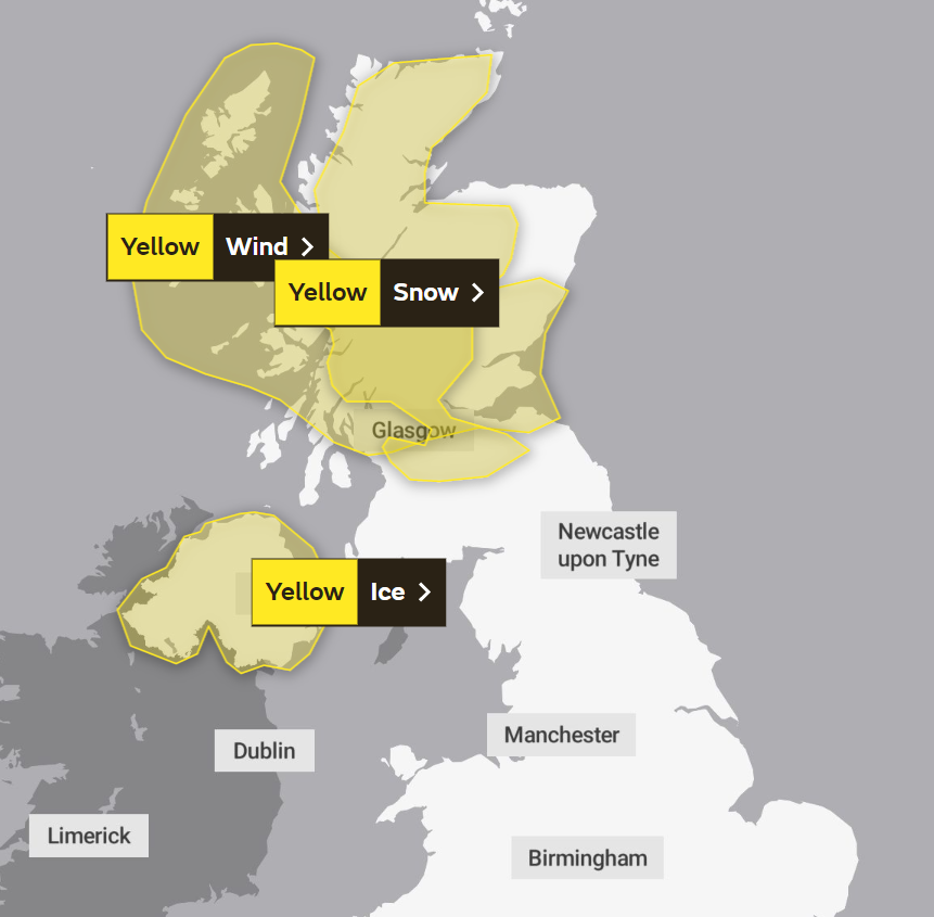
Where are weather warnings in force?
The Met Office has issued a yellow snow warning for much of Scotland, a wind warning for the Western Isles and much of the mainland below Aberdeen. Northern Ireland is covered by a yellow ice warning.
The snow and ice warnings are in place over this evening and tomorrow. The wind warning is in place for tomorrow.
Snow dusts the Cairngorms
An early photo of snow in Scotland today from Pete Crane at the Cairngorms National Park Authority.
Mr Crane said this picture was taken around 5pm.
Update: Where are weather warnings in force?
A more detailed map of the areas under yellow warnings for you here from the BBC:
Winds set to reach 75mph in Scottish Isles
A yellow weather warning for strong gale force winds is in place for Scotland’s Western Isles from Thursday at 3am until 12pm.
Forecasters warned the brief period of severe westerly winds will develop across the Western Isles at first, bringing gusts up to 70-75 mph, with the Uists most likely to see the strongest winds.
The blustery weather will then shift eastwards, with gusts typically reaching about 50mph, and 60 mph in some locations, according to the Met Office.
Weather experts said while such wind speeds are not unusual for the time of year in Scotland, recently weakened trees and structures from the impact of Storm Corrie and Storm Malik may mean further damage in some areas is likely.
The Met Office forecast for the rest of the week states:
Tonight
Occasional rain affecting southern England. Cold further north with wintry showers, before more persistent rain and hill snow arrive across Scotland. Gales in the north, severe on some coasts later.
Thursday
Rain clearing southern England, then southern and eastern parts bright. Rain and hill snow across Scotland will be replaced by wintry showers. Windy in the north, severe gales at first.
Outlook for Friday to Sunday
Friday fine and dry for many after a frosty start. Turning wet and windy across the northwest later, this then spreading to all parts over the weekend and turning milder.
Where is snow expected?
A yellow weather warning for snow is in place until 11am on Thursday, with forecasters warning of potential disruption to travel.
The main areas affected include Central, Tayside and Fife, south west Scotland and Lothian Borders, Strathclyde, Highlands and Grampian.
Accumulations of 2-5cm of snow are possible in areas above 200 metres elevation, with possibly about 10cm on some of the higher routes above 400 metres.
Power outage warning
The Met Office has issued warnings of short term power outages and loss of other services in the areas where yellow severe weather warnings have been issued.
The cold wave hitting parts of the UK is expected to also lead to delays to road, rail, air and ferry transport.
Driving conditions will also become difficult and would lead to possible delayed high-sided vehicles on exposed routes and bridges.
The Met has issued a yellow snow warning for much of Scotland, a wind warning for the Western Isles and much of the mainland below Aberdeen. Northern Ireland is covered by a yellow ice warning.
Join our commenting forum
Join thought-provoking conversations, follow other Independent readers and see their replies
Comments