Met Office warns of thunderstorms today as UK set for 34C on hottest day of year
Southeast of England could reach 34C while others see thunderstorms
Your support helps us to tell the story
From reproductive rights to climate change to Big Tech, The Independent is on the ground when the story is developing. Whether it's investigating the financials of Elon Musk's pro-Trump PAC or producing our latest documentary, 'The A Word', which shines a light on the American women fighting for reproductive rights, we know how important it is to parse out the facts from the messaging.
At such a critical moment in US history, we need reporters on the ground. Your donation allows us to keep sending journalists to speak to both sides of the story.
The Independent is trusted by Americans across the entire political spectrum. And unlike many other quality news outlets, we choose not to lock Americans out of our reporting and analysis with paywalls. We believe quality journalism should be available to everyone, paid for by those who can afford it.
Your support makes all the difference.People across the UK are bracing for two different types of extreme weather on Monday, with some facing the hottest day of the year while other regions expect thunderstorms.
Temperatures in the south of England are set to soar to an ‘intense’ 34C on Monday in what the Met Office has predicted to be the hottest day of the year so far.
The forecasters said warm air will move up from Europe through the weekend and on Monday, before temperatures dip once again on Tuesday.

The heat is likely welcomed by most, as Britain has seen a largely drizzly and grey summer so far, with only brief periods and sunshine being seen across the nation.
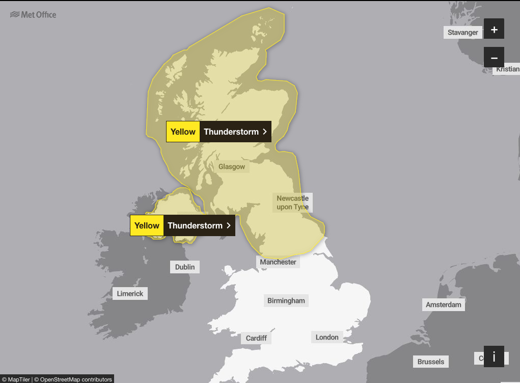
However, not everyone will be able to enjoy the fleeting signs of summer this week, with the forecasters issuing yellow weather warnings for large swathes of the UK on Monday.
The hot weather will be driven by tropical storms from North America, according to the weather authority.
Met Office deputy chief meteorologist, Dan Holley said: “Along with the rise in temperatures, there is also an increasing threat of heavy rain and thunderstorms on Sunday night and into Monday.
“This looks most likely across portions of Wales, northern England, Northern Ireland and southern and eastern Scotland, but the advice is to keep up to date with the latest forecast and any warnings by checking our website or app.”
Mr Holley, said: “We expect to see a relatively brief hotter and more humid spell of weather for Sunday and Monday, before these hotter conditions recede on Tuesday, allowing more unsettled conditions to return.
“This change to hotter conditions is caused, in part, by the effects of Tropical Storm Debby in North America. Debby is helping to strengthen the jet stream, causing it to meander over the Atlantic. This will allow hot air over France to move into the UK later this weekend, and early next week.”
Pollen and UV levels will also increase as temperatures rise.
The hot weather may continue in some areas on Tuesday, the Met Office said when the hot air will likely be displaced by fresher weather conditions.
The weather is then set to become unsettled again with occasional showers.

MET OFFICE OUTLOOK
Monday:
A very hot and humid day in the south with some sunny spells and staying largely dry. Some isolated afternoon thunderstorms are possible in eastern England. Cooler in the north with spells of heavy rain and thunderstorms during the morning.
Monday night:
Another warm and humid night in southeast England, but feeling fresher elsewhere. Mostly dry and clear at first, but cloud and patchy rain pushes into the west after midnight.
Tuesday:
Gradually turning cloudier through the day with outbreaks of light rain in places. Staying dry and hot in eastern England, but fresher elsewhere. Turning windy across Scotland and Northern Ireland.
Outlook for Wednesday to Friday:
Largely dry and bright on Wednesday. Windy on Thursday with a spell of heavy rain. Sunny spells and a few showers on Friday. Temperatures returning closer to average.
Join our commenting forum
Join thought-provoking conversations, follow other Independent readers and see their replies
Comments