UK weather: Temperatures set to rise during half term after cold snap
Mercury to hit double digits across most of country, Met Office say, following weeks of cold weather alerts

Your support helps us to tell the story
From reproductive rights to climate change to Big Tech, The Independent is on the ground when the story is developing. Whether it's investigating the financials of Elon Musk's pro-Trump PAC or producing our latest documentary, 'The A Word', which shines a light on the American women fighting for reproductive rights, we know how important it is to parse out the facts from the messaging.
At such a critical moment in US history, we need reporters on the ground. Your donation allows us to keep sending journalists to speak to both sides of the story.
The Independent is trusted by Americans across the entire political spectrum. And unlike many other quality news outlets, we choose not to lock Americans out of our reporting and analysis with paywalls. We believe quality journalism should be available to everyone, paid for by those who can afford it.
Your support makes all the difference.Temperatures are set to jump into double figures during the half-term break after weeks of cold weather.
Highs of 14C are expected in Wales and parts of England, despite periods of rain and winds.
It is gearing up to be a week of two halves, Met Office forecaster Jonathan Vautrey told The Independent, with an initial bout of dry and calm weather becoming increasingly changeable and more unsettled.

Despite potentially heavy rain pushing its way across the country in the second half of the week, conditions will remain relatively mild, with southerly winds helping to tap into some of the mild air around Iberia and bring that up to ourselves, said Mr Vautrey.
However, meteorologists are keeping an eye on the potential for gales on Thursday night in coastal parts of Scotland and mountainous regions, including the Pennines – and a weather warning may be issued.
Yesterday saw more sunshine and blue skies than the cloudy and overcast weekend.
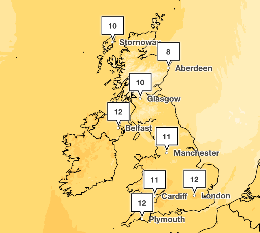
Highs of 10C are forecast across the south of England by mid-afternoon, and a similar picture is expected across most of the UK, with the mercury to hit 11C in Northern Ireland and north Devon.
After a breezier night bringing a chance of rain and frost, the mild weather is set to intensify on Tuesday, when most of the UK will enjoy double-digit temperatures.

This will be complemented by warm sunny spells, with temperatures expected to climb as high as 14C in Aberystwyth and Barnstaple by 3pm.
The highest winter temperature ever recorded in the UK was 21.2C at Kew Gardens on 26 February 2019.
While there could be outbreaks of rain in Scotland, northern England and Northern Ireland on Tuesday, “elsewhere it will be a dry and fine day with plenty of sunshine and feeling quite pleasant” in light winds, said Met Office meteorologist Rachel Ayers.

Giving a broad outlook for the week ahead, Ms Ayers added: “High pressure isn’t going to go too far away, so it will be mostly settled but weather fronts will just try and make their way in from the west at times, bringing a bit more cloud and rain sometimes.”
That process will begin in earnest on Wednesday, when a mist of fog will be followed by cloudy spells of rain arriving in the northwest and spreading southeastward, with sunshine and showers following into the north, according to the Met Office.
Friday is expected to be a drier day, particularly in the southeast, where there will be sunny spells and highs of 13C in London and Cambridge – contrasting with peak temperatures of 7 or 8C in the Scottish Borders and further north.
Widespread cloud and some bands of rain will move eastwards through the day, giving way to clearer conditions with sunny spells and showers, which will be heavy at times in the north, the Met Office said.
The forecast suggests many of the pupils and teachers breaking for the February mid-term could enjoy decent spells of sunshine.
The week-long break gets underway on Monday for many schools in Scotland, England and Wales, although others will enjoy half-term the following week.
MET OFFICE WEATHER
Today:
Cloud breaking up more widely through the day with sunny spells developing, although cloud perhaps lingering in Northern Ireland, as well as central and eastern England. Mild.
Tonight:
Clear spells although probably turning cloudier/breezier in the west overnight with outbreaks of rain developing over Northern Ireland and perhaps southwest Scotland by dawn. Some patchy fog, especially southeast England.
Tuesday:
Fog and low cloud in southeast lifting and clearing during morning. Thicker cloud and some rain/drizzle across northwest at times. Otherwise dry with sunny spells and feeling warm in places.
Outlook for Wednesday to Friday:
Some early mist of fog Wednesday, then cloudy with spells of rain arriving in the northerwest and spreading southeastward, sunshine and showers following into the north. Drier on Friday. Mild.


Join our commenting forum
Join thought-provoking conversations, follow other Independent readers and see their replies
Comments