UK weather: Storm Agnes forecast to bring heavy rain and winds up to 80mph
Met Office says this week could feature frequent bouts of heavy rain and strong winds

Your support helps us to tell the story
From reproductive rights to climate change to Big Tech, The Independent is on the ground when the story is developing. Whether it's investigating the financials of Elon Musk's pro-Trump PAC or producing our latest documentary, 'The A Word', which shines a light on the American women fighting for reproductive rights, we know how important it is to parse out the facts from the messaging.
At such a critical moment in US history, we need reporters on the ground. Your donation allows us to keep sending journalists to speak to both sides of the story.
The Independent is trusted by Americans across the entire political spectrum. And unlike many other quality news outlets, we choose not to lock Americans out of our reporting and analysis with paywalls. We believe quality journalism should be available to everyone, paid for by those who can afford it.
Your support makes all the difference.Strong winds and heavy rain are set to batter the UK as Agnes, the first named storm of the season, sweeps across the country this week.
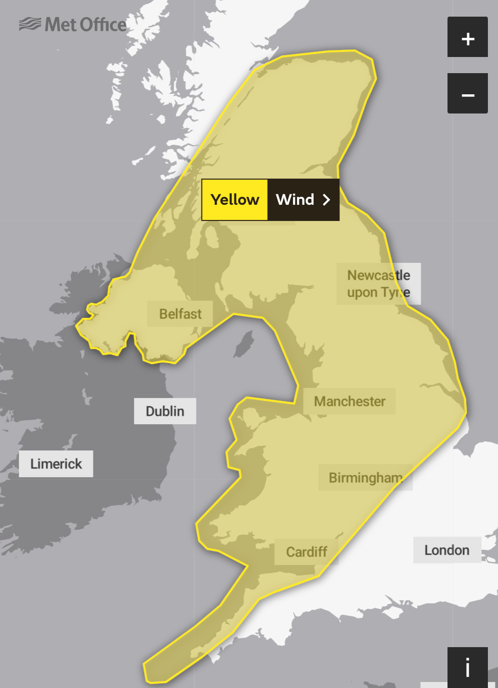
The Met Office has issued a danger to life warning for Wednesday and Thursday, covering large swathes of the country. Gale force winds could also result in travel disruption, damage to buildings and a small chance of power cuts, the forecaster has warned.
Met Office chief meteorologist Steve Ramsdale said: “While the precise track and depth of Storm Agnes is still being determined, there’s a high likelihood of wind gusts around 50mph to 60mph for some inland areas. Exposed coastal areas could see gusts of 65mph to 75mph with a small chance of a few places seeing around 80mph.
“As well as some very strong winds for many, Storm Agnes will also bring some heavy rain, with the highest totals more likely in Scotland, northern England, Wales and Northern Ireland. Around 60mm of rain is possible in a few places over high ground in Scotland.”
Storm Agnes follows a week of heavy downpours in parts of the UK. Britain was hit by the remnants of two hurricanes, Lee and Nigel, dumping large amounts of rain that led to flooding in London and other parts of the country.


On Tuesday, before the storm hits, showers and occasional longer spells of rain are predicted throughout the day.
Conditions are expected to become mostly dry during the afternoon in the southern regions, with light winds. Northern areas, however, will continue to experience wet and windy weather.
Mark Sidaway, deputy chief meteorologist at the Met Office, said: “There is some uncertainty on the precise track and strength of this weather system, however the most likely outcome at present is for a wide swathe of 50 to 60 mph gusts affecting inland areas,” he said.
“A yellow warning for wind has been issued for much of the country from 10am on Wednesday to 7am on Thursday. Some Irish Sea coasts could see gusts of 65 to 75 mph, with a small chance of 80 mph gusts on the most exposed coasts and headlands.”
Agnes is the first named storm of the season, which started on 1 September, and follows storms Antoni and Betty last month.
MET OFFICE WEATHER OUTLOOK
Monday:
Early cloud soon clearing to leave a fine and dry day, with some good spells of sunshine for many. Feeling rather warm in the sunshine, although it will remain on the breezy side. Maximum temperature 22C.
Monday evening:
Dry with clear spells overnight. Perhaps a few mist and fog patches forming in places before dawn. Generally a mild night, with lighter winds. Minimum temperature 10C.
Tuesday:
After a dry and bright start, some heavy and possibly thundery showers are likely to move quickly northeastwards during the morning. Sunny spells and a few showers following. Feeling warm. Maximum temperature 23C.
Outlook for Wednesday to Friday:
Dry start Wednesday, before wet and windy weather sweeps quickly northeastwards overnight, risk of gales. Sunshine and scattered showers on Thursday and Friday. Windy. Temperatures around average by day. Mild nights.
Join our commenting forum
Join thought-provoking conversations, follow other Independent readers and see their replies
Comments