UK braced for cold snap with Arctic winds set to cause ‘shock to the system’
But temperatures should return towards average by the weekend, the Met Office said

Your support helps us to tell the story
From reproductive rights to climate change to Big Tech, The Independent is on the ground when the story is developing. Whether it's investigating the financials of Elon Musk's pro-Trump PAC or producing our latest documentary, 'The A Word', which shines a light on the American women fighting for reproductive rights, we know how important it is to parse out the facts from the messaging.
At such a critical moment in US history, we need reporters on the ground. Your donation allows us to keep sending journalists to speak to both sides of the story.
The Independent is trusted by Americans across the entire political spectrum. And unlike many other quality news outlets, we choose not to lock Americans out of our reporting and analysis with paywalls. We believe quality journalism should be available to everyone, paid for by those who can afford it.
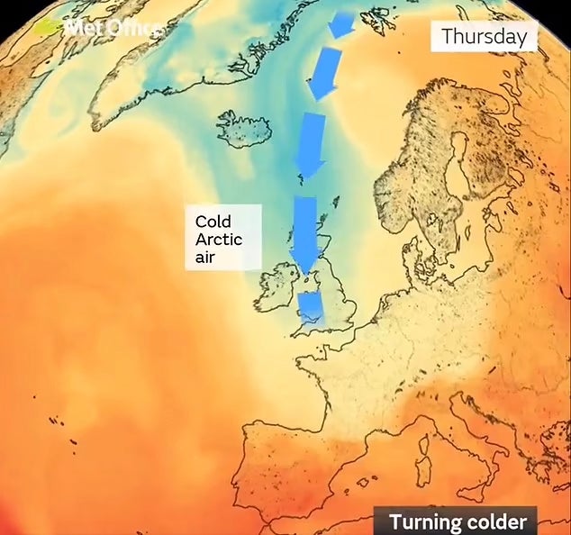
Your support makes all the difference.The UK will suffer an “unseasonably cold” few days as Arctic winds sweep across large parts of the country.
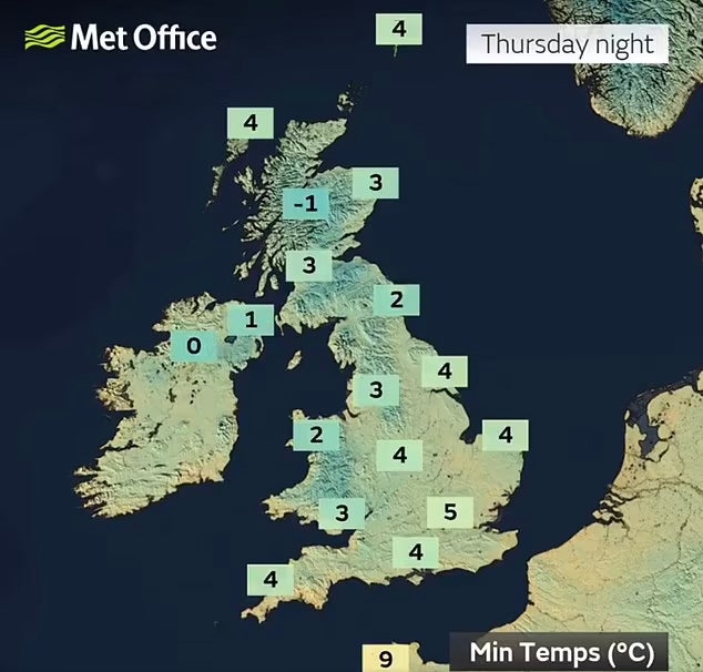
Friday morning may be a “shock to the system” and is likely to be the coldest it gets this week, as cold air is expected to bring temperatures down to around 4 to 6C below average for this time of year.
Jonathan Vautrey of the Met Office said: “Many of us will see temperatures in the mid-teens – around 13 to 14C – whereas normally at this time of year it would be at least 16 to 18C, if not closer towards 19 to 20C in the far South East, places like London.”

But some areas further north will see temperatures drop to “single figures” as a result of strong winds, particularly from Thursday night going into Friday, with temperatures in some areas potentially falling below freezing.
Mr Vautrey added: “We could see some patchy frost developing in rural areas across all nations of the UK, particularly Scotland.
“For people waking up on Friday morning it could be quite a shock to the system as they’re walking out of the door.”
The highest peaks in Scotland may see some snowfall as a result of the frosty temperatures.
“There is a small chance of some snow falling over the highest mountains of Scotland, but you’ll have to hike quite a way before you see any snow,” Mr Vautrey said.

Forecast for the week ahead
Earlier in the week on Wednesday, wet, windy and cold weather will prevail as the cold front moves in, with scattered and blustery showers widespread in the North and West.
Showers will continue into Thursday but be accompanied by some sunshine in many areas, as the weather becomes a little drier and less windy throughout the day - before the UK sees its coldest night going into Friday.
Despite the frosty temperatures, Friday will be largely dry across the UK, until a front of rain strikes the North West later in the evening.
Friday will be the end of the cold snap as temperatures begin to climb back up by the weekend, as warmer air “pushes back” against the cool Arctic winds, the Met Office said.
The Met Office added: “Looking further ahead, milder air from the Atlantic is expected to push back across the country later on Friday and more especially into the weekend, cutting off the cold air from the north and seeing a return to temperatures nearer average for the time of year.”
After a weekend of rain for those in southern areas, many will be hoping for more pleasant autumnal weather from this weekend onwards.
In its long-range forecast from Sunday 15 September until Tuesday 24 September, the forecaster predicts temperatures are “likely to be on the warmer side of average, but with settled conditions warm days could be offset by a few chilly nights”.
The Met Office added: “Towards the end of this period there is a signal that the more settled conditions may cease.”
Join our commenting forum
Join thought-provoking conversations, follow other Independent readers and see their replies
Comments