Four storms are brewing in the Atlantic as hurricane season peaks - but will any impact the US?
The Atlantic hurricane season has been strangely quiet since Ernesto last month
Your support helps us to tell the story
From reproductive rights to climate change to Big Tech, The Independent is on the ground when the story is developing. Whether it's investigating the financials of Elon Musk's pro-Trump PAC or producing our latest documentary, 'The A Word', which shines a light on the American women fighting for reproductive rights, we know how important it is to parse out the facts from the messaging.
At such a critical moment in US history, we need reporters on the ground. Your donation allows us to keep sending journalists to speak to both sides of the story.
The Independent is trusted by Americans across the entire political spectrum. And unlike many other quality news outlets, we choose not to lock Americans out of our reporting and analysis with paywalls. We believe quality journalism should be available to everyone, paid for by those who can afford it.
Your support makes all the difference.The Atlantic hurricane season may have been eerily quiet over the last few weeks, but it’s far from over.
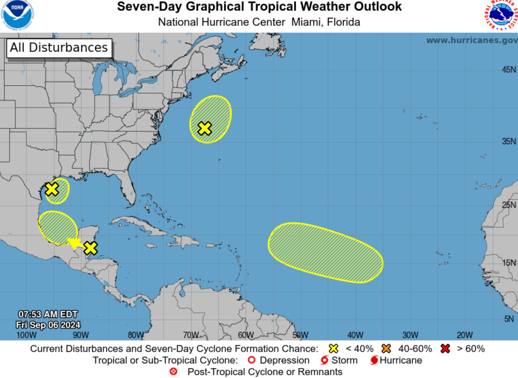
Four tropical disturbances are currently being tracked across the ocean, although National Weather Service forecasters said Friday afternoon that only a couple have the potential for cyclone formation.
The agency is tracking systems in the Northwestern and Southwestern Gulf of Mexico, the Northwestern Atlantic, and the Eastern and Central Tropical Atlantic.
A tropical wave in the Southwestern Gulf of Mexico is producing showers and thunderstorms, and there is a medium chance that a tropical depression could form next week. The system is expected to head northeastward. There is only a low chance that a cyclone could form in the Eastern and Central Tropical Atlantic over the next week.
This year’s hurricane season has seen only five named storms but got off to an explosive start.
Hurricane Beryl, the first major storm of the 2024 season, formed in late June. In July, it became the earliest Category 5 hurricane observed in the Atlantic and the strongest July Atlantic hurricane on record.
Ernesto, which formed as a disturbance in mid-August, strengthened into a hurricane two days later. The Category 2 storm weakened before it lashed Bermuda.
While early September is peak hurricane season, not a single named storm has formed in the Atlantic since Ernesto. The next Atlantic storm would be named Francine.

Initial forecasts from the National Oceanic and Atmospheric Administration said 2024 would be an above average season, including as many as 25 named storms. An update from scientists still predicted as many as 24 at the beginning of August.
Of course, there’s still months to see more hurricanes as the Atlantic season starts on the first day of June and concludes at the end of November. Plus, there are several remarkable factors that are expected to contribute to this active season, including record sea surface temperatures across the North Atlantic and high ocean heat content in the Gulf of Mexico.
A hotter ocean leads to an increase in atmospheric water vapor that fuels the weather systems and packs them with more precipitation.
The lull since Ernesto was explained by Colorado State University meteorologist Dr. Philp Klotzbach and other researchers in a report this week with “forecast thoughts” on the current seasonal outlook.
Potential reasons for the recent “dearth” in Atlantic hurricane activity include that a northward-shifted monsoon trough – an elongated area of relatively low atmospheric pressure – has resulted in African easterly waves emerging too far north.
Another is that extremely warm temperatures in the upper atmosphere have resulted in atmospheric stabilization - and thunderstorms form when the air is unstable.

A third reason could be too much easterly changes in windspeed or direction in the eastern Atlantic. Lastly, and more recently, there is unfavorable subseasonal variability associated with the Madden-Julian oscillation, the researchers said.
The Madden-Julian Oscillation - like the better known El Niño Southern Oscillation - is a climate phenomenon. It describes the eastward moving disturbance of clouds, rain, winds, and pressure, that traverses the planet in the tropics and returns to its start point in 30 to 60 days.
While El Nino has persistent, season-long features over the Pacific, there can be multiple Madden-Julian events within a season. While it had been broadly favorable for Atlantic hurricane activity in late August, the report said it has since moved.
“We believe that it is likely a combination of these factors (and perhaps others) that have led to this recent quiet period,” the authors said. ”We still do anticipate an above-normal season overall, however, given that large-scale conditions appear to become more favorable around the middle of September.”
Klotzbach wrote on social media Wednesday that the warm Atlantic, a trend towards a La Niña climate pattern, and forecast low shear indicate that the season may still pick up in its second half.

Join our commenting forum
Join thought-provoking conversations, follow other Independent readers and see their replies
Comments