UK weather live: Met Office warning as over a month’s rain to fall in two days on southern Britain
The Met Office say the weather will remain unsettled this weekend
Your support helps us to tell the story
My recent work focusing on Latino voters in Arizona has shown me how crucial independent journalism is in giving voice to underrepresented communities.
Your support is what allows us to tell these stories, bringing attention to the issues that are often overlooked. Without your contributions, these voices might not be heard.
Every dollar you give helps us continue to shine a light on these critical issues in the run up to the election and beyond

Eric Garcia
Washington Bureau Chief
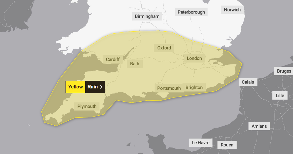
More than half a month’s rain has fallen across two days in southern England and Wales up to Friday night.
A Met Office yellow weather warning was in place for the second day running as wet weather continued due to large patches of rain crossing the channel from France, but had subsided by Saturday morning.
There were warnings for flooding, power cuts and travel disruption with outbreaks of heavy rain “persistent” in some areas and “particularly heavy” in others.
For the weekend, for many, it will be a bright and dry start on Saturday morning with small bands of rain moving westward across the country.
Met Office chief meteorologist Matthew Lehnert said: “Repeated areas of rain are likely to affect southern Britain over the next few days, generating some localised impacts into the weekend.
“It’s a different story further north though, as high pressure brings warmer and sunnier conditions, with higher-than-average temperatures, particularly across parts of western Scotland. Eastern areas are likely to be cooler and at times, cloudier due to winds blowing off the North Sea.”
‘North/south divide’ - warm Friday expected for northern areas
While the South is battered by heavy rain for two days, temperatures in the west and northwest of Scotland could reach up to 27 C.
Warm weather will stretch to some parts of Northern Ireland, and western and central England.
Met Office Deputy Chief Meteorologist Brent Walker said: “Areas in western Scotland could see maximum temperatures of 26°C on Friday. If the wind were to shift a little, 27°C could even be on the cards for some places in the west as they pick up the foehn effect, which causes warming and drying of air on the lee side of high ground.”
There will be a clear “north/south divide” in the weather, the Met added.
Chief Meteorologist Jason Kelly explained: “[The south is] a different story to the north of the UK though, as high pressure brings warmer and sunnier conditions, with higher-than-average temperatures, particularly across parts of western Scotland. Eastern areas are likely to be cooler and at times, cloudier due to winds blowing off the North Sea.”
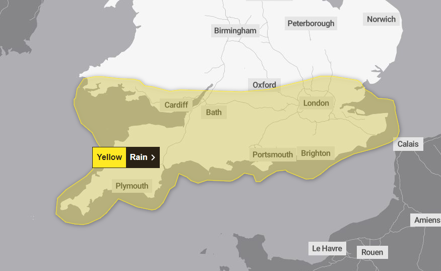
Weather warning area for Friday shifts south and east
The Met Office have adjusted the weather warning area for Friday.
Oxford and the surrounding area north are no longer included in the yellow weather warning, which is set to bring torrential rain to large parts of the southern UK.
The south western corner of Wales is also now at risk of heavy rain, the revised map shows.
How high is the flooding risk?
The Met Office has warned residents in affected areas to check whether their property is at risk of flooding.
It says there is a “small chance of fast flowing or deep floodwater causing danger to life” on both Thursday and Friday, leading to potential travel disruption, damage to homes and buildings, and the small possibility that “some communities will become cut off by flooded roads”.
Those who may be at risk of flooding should consider preparing an emergency flood kit and a food plan, the Met Office said.
“Where flooding occurs, there is a slight chance of delays or cancellations to train and bus services. Spray and flooding could lead to difficult driving conditions and some road closures.”
But there are currently no alerts in place from the Environment Agency, which is responsible for putting out flood alerts for areas which could be at risk.
Month’s worth of rain possible in two days
The worst affected areas over the next two days could see up to a month of rainfall in the space of just hours.
Heavy downpours over longer periods could see as much as 80mm to 100mm of rain for locations which are affected repeatedly - which the Met say is possible during the second half of Thursday.
Moving into Friday, the worst affected areas will likely see 40-60mm throughout the day, with a lower likelihood of some areas seeing as much as 75-100mm. Rain may also be accompanied by thunderstorms.
With the average September rainfall for southern England and South Wales around 60-90mm, some areas could smash their average in the space of just hours.

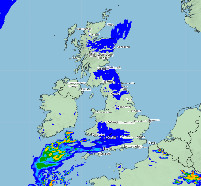
The picture across the UK on Thursday - weather maps
Here’s how the day is going to unfold across the UK, according to the Met Office weather maps.
Dark blue patches mean less than 0.5mm, green to yellow patches means 2mm - 8mm, while red patches mean more than 32mm.
10am - Rain creeps in from the south

2pm - Heavy rain possible across southern UK

6pm - Rain shifts west

10pm - Heavy rain over for Thursday
Wet start to autumn follows an underwhelming summer
After the coldest summer since 2015, many hope autumn will be more kind.
But with two yellow warnings in place for large parts of the southern UK, those prayers haven’t yet been answered.
In summer 2024, the Met Office says temperatures were overall 0.22°C below the UK’s long-term meteorological average - with cool weather particularly in Scotland and Northern Ireland.
“Mean temperatures in both June and July were below average, with temperatures in August only slightly above. This was largely due to northerly winds bringing cold Arctic air to the UK in June and July, while August saw an increase in westerly winds bringing slightly warmer Atlantic air,” explained Met Office scientist Emily Carlisle.
The UK experienced around average rainfall, with 241.3mm of rain meaning it was 5 percent less than usual.
There was significant regional variation over the summer, with Scotland experiencing 18 percent more rainfall than its seasonal average while England experienced 23 percent less.
Northern and western parts of the UK suffered higher than average rainfall, while southern and eastern areas had a drier summer than usual.
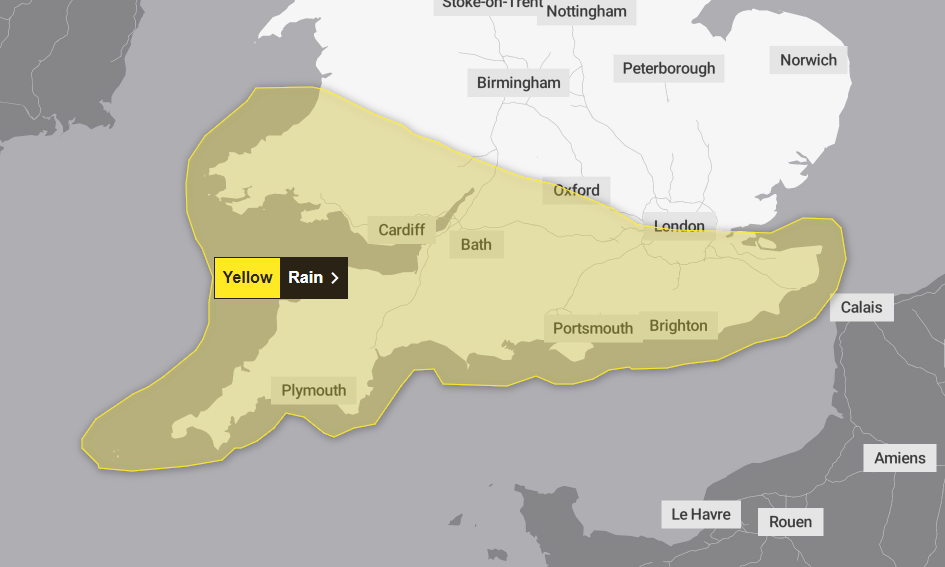
Met Office issues yellow weather warnings for Thursday and Friday
The Met Office has issued yellow weather warnings for Thursday and Friday, with flooding, power cuts, and damage to buildings possible over the next 48 hours.
Some areas will see “heavy downpours” on Thursday, with “possibly even as much as 80 to 100 mm if repeated batches of heavy rain affect the same locations”.
This is more likely during the second half of Thursday, the office says.
Moving into Friday, the risk of potential weather impact increases as persistent rain takes its toll.
“Rainfall totals of 15-30 mm are expected widely, however, the wettest areas are likely to see 40-60 mm through the whole of Friday with a lower likelihood of a few areas seeing as much as 75-100 mm,” the Met Office said.
Subscribe to Independent Premium to bookmark this article
Want to bookmark your favourite articles and stories to read or reference later? Start your Independent Premium subscription today.
Join our commenting forum
Join thought-provoking conversations, follow other Independent readers and see their replies
Comments