UK weather live: Commuters suffer delays due to heavy rain and flooding as new Met Office warning issued
The railway line between Swindon and Bristol Parkway is blocked
Your support helps us to tell the story
My recent work focusing on Latino voters in Arizona has shown me how crucial independent journalism is in giving voice to underrepresented communities.
Your support is what allows us to tell these stories, bringing attention to the issues that are often overlooked. Without your contributions, these voices might not be heard.
Every dollar you give helps us continue to shine a light on these critical issues in the run up to the election and beyond

Eric Garcia
Washington Bureau Chief
Rail passengers face delays to their journeys due to flooding this evening as the Met Office issues a fresh weather warning for wind over the weekend.
The railway line between Swindon and Bristol Parkway is blocked, which has resulted in services between London and Bristol and Wales having to be diverted, where possible, said National Rail.
It means passengers are facing delays of up to 30 minutes.
The disruption follows heavy rainfall this week, and comes ahead of a new weather warning from the Met Office with areas of south west England and Wales to be blasted by winds of up to 60mph on Sunday.
The forecaster has issued the yellow weather warning for the region on Sunday from 9am until 11:59pm,
“A yellow warning for wind has been issued for much of Sunday across portions of southwest England and south and west Wales, where gusts could reach or even exceed 60 mph on exposed coasts, and 50-55 mph more widely,” Met Office Deputy Chief Meteorologist Dan Holley said.
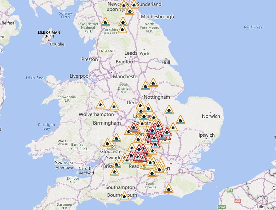
The Environment Agency also has 59 flood warnings in place across England, meaning flooding is expected, and 115 flood alerts, meaning flooding is possible.
‘Increased risk of impacts’
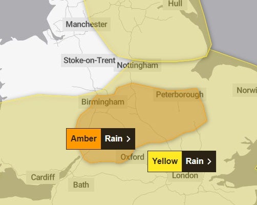
The Met Office has now provided some commentary on the recently issued amber warning, explaing what many parts of the UK should face this afternoon and evening.
As we’ve already said, many parts of the UK are covered by a yellow warning for rain, although a central region of England has seen its alert heightened to amber this morning.
Met Office Chief Meteorologist, Neil Armstrong, said: “We are expecting an area of slow-moving showers and thunderstorms to develop this afternoon and evening across parts of the Midlands.
“The rain will fall onto already saturated ground, potentially affecting communities still recovering from recent flooding. An amber warning as been issued covering the areas of increased risk of impacts.
Flood warnings in place
Over the past 24 hours, 19 flood warnings have been removed by the Environment Agency, but there are still 27 in place, where flooding is expected.
The flood warnings, most of which are in Bedfordshire and Northamptonshire, are in place due to further rain expected on Thursday and Friday.
There are also 65 flood alerts in place, where flooding is possible.
Visualisation shows why amber warning is in place
The Met Office has issued a graphic showing how the band of rain will impact central England from tonight into Friday morning:
What should people expect in am amber warning?
The Met Office has issued an amber warning for rain for a central region of England. Here is what the agency says people should expect:
- Spray and flooding probably leading to difficult driving conditions and some road closures
- Homes and businesses are likely to be flooded, causing damage to some buildings
- A good chance some communities will be cut off by flooded roads
- Delays and some cancellations to train and bus services are likely
- Power cuts and loss of other services to some homes and businesses likely
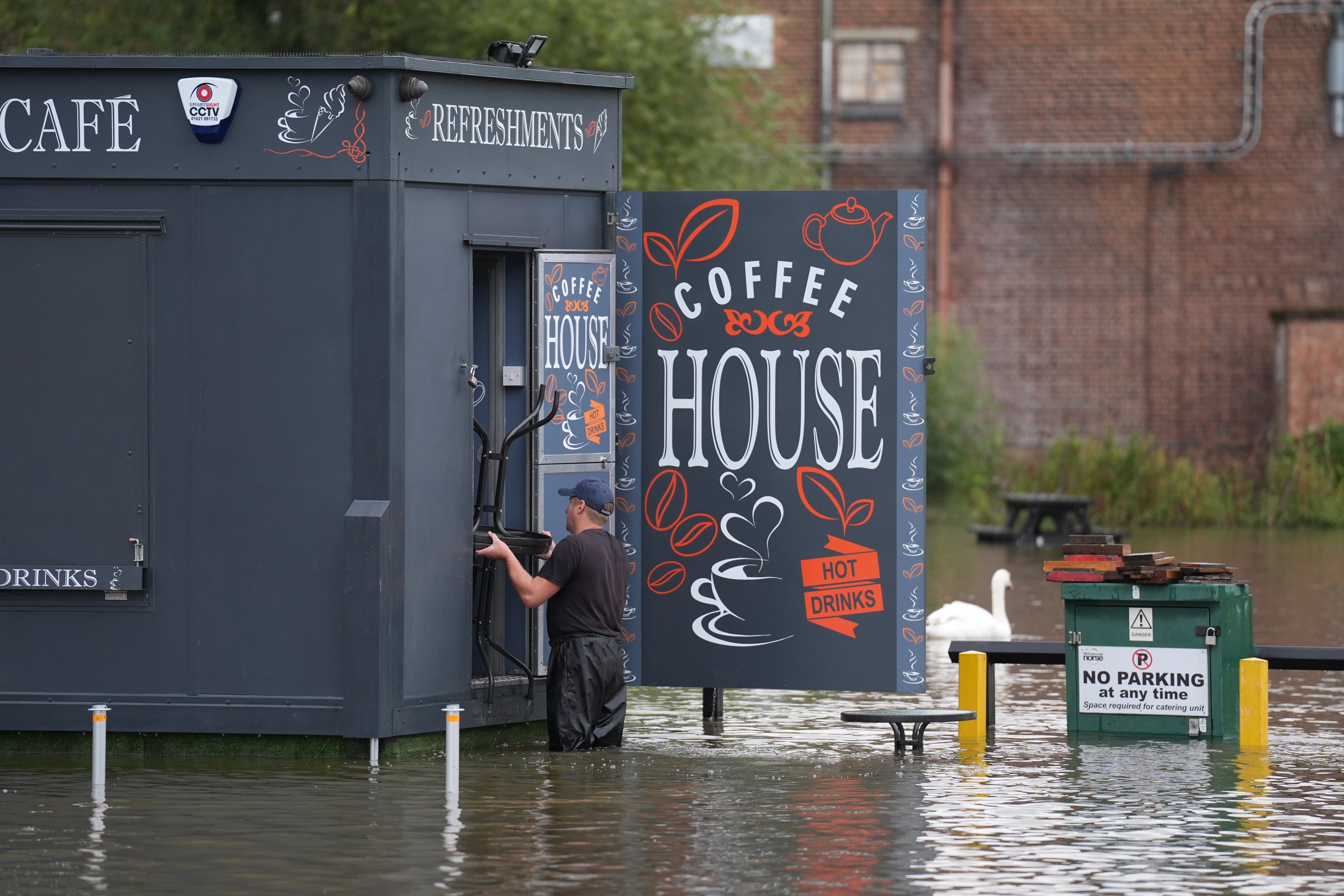
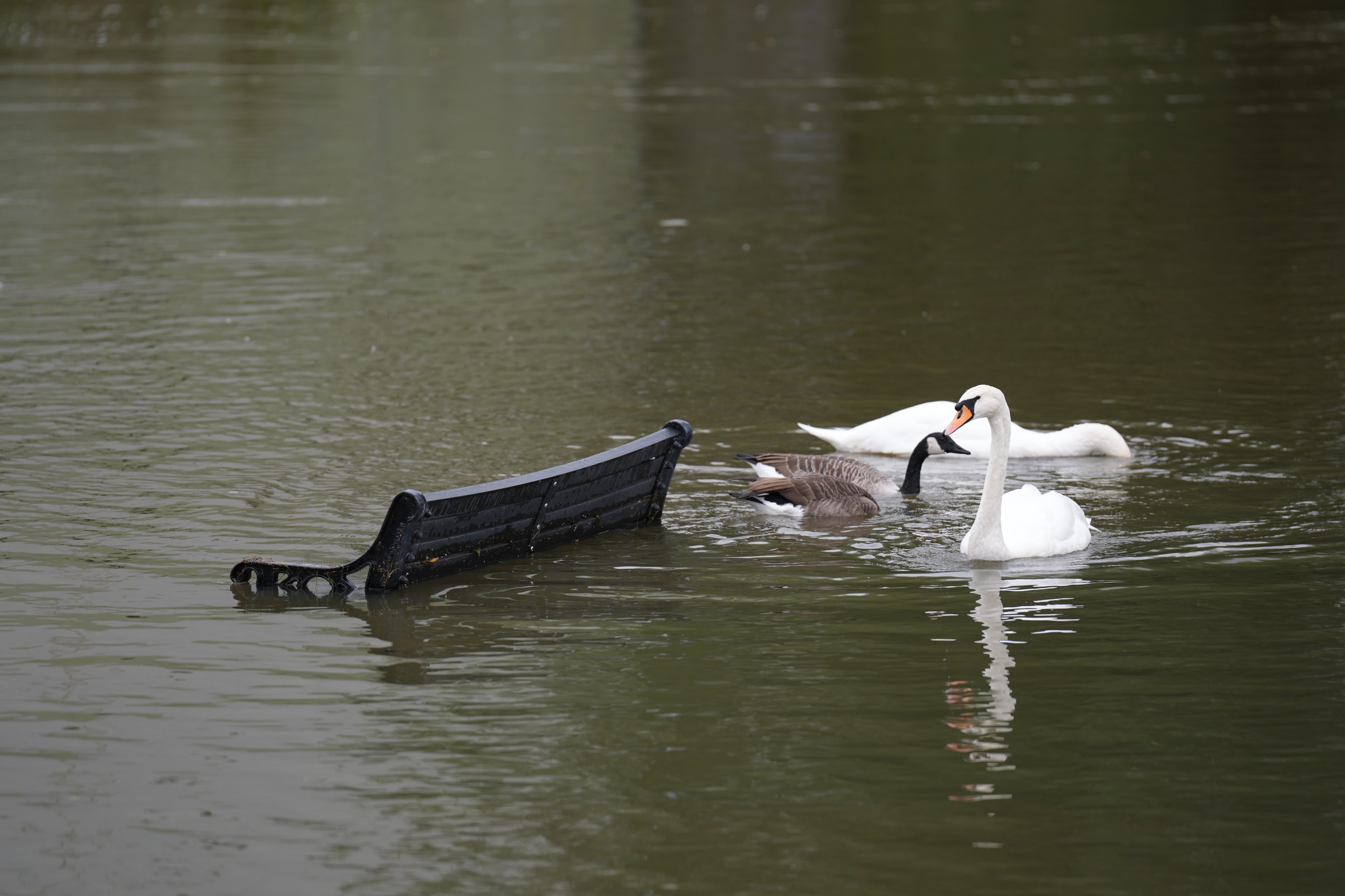
In pictures: Areas still flooded from rain earlier this week
In Northamptonshire, some low lying areas were badly impacted by the rain earlier this week.
At the Billing Aquadrome leisure park, residents had to be evacuated from their homes, while several main roads were also shut due to flooding.
Pictures today show how some areas are still impacted.

Amber weather warning issued by Met Office
The Met Office has just raised its warning for heavy rain for a central part of England from a yellow alert to amber.
This means that heavy rain is likely to cause flooding and transport disruption this evening and overnight.
The region has already suffered flooding following downpours earlier in the week, in particular, in low lying areas in Northamptonshire and Bedfordshire.
The south of England and Wales will be the worst affected areas today
With rain forecast across many regions of the UK today, a yellow weather warning is in place for the south of England and Wales, and will remain in place until Friday morning at 9am.
The Met Office says people in areas such as Birmingham, London, Bristol and Cardiff should expect heavy rain with the potential for flooding and disruption to transport.
There’s also a chance of thunderstorms.
The Met Office says: “Whilst some areas will miss the worst, heavy showers and some thunderstorms will occur during today, potentially becoming more organised across a swathe of Wales and into central and eastern England during Thursday evening and on into early Friday morning.”
Movement of bands of rain across the UK
As this graphic from the Met Office shows, the day begins with heavy showers in the north east before later in the day, from around 11am, bands of rain drift up through the south of the country where there is a yellow weather warning in place.
Subscribe to Independent Premium to bookmark this article
Want to bookmark your favourite articles and stories to read or reference later? Start your Independent Premium subscription today.
Join our commenting forum
Join thought-provoking conversations, follow other Independent readers and see their replies
Comments