Storm Ashley latest: ‘Danger to life’ warning as UK to be battered by 80mph winds this weekend
Met Office warns of damage to buildings, power cuts and travel disruption during Storm Ashley

Your support helps us to tell the story
This election is still a dead heat, according to most polls. In a fight with such wafer-thin margins, we need reporters on the ground talking to the people Trump and Harris are courting. Your support allows us to keep sending journalists to the story.
The Independent is trusted by 27 million Americans from across the entire political spectrum every month. Unlike many other quality news outlets, we choose not to lock you out of our reporting and analysis with paywalls. But quality journalism must still be paid for.
Help us keep bring these critical stories to light. Your support makes all the difference.
Injuries and danger to life are likely during the 80mph winds set to hit parts of the UK this weekend in the first named storm of the season.
The Met Office has issued an amber weather warning for northwest Scotland on Sunday, as well as a yellow warning for the entirety of Scotland and Northern Ireland, and parts of north-west England and Wales.
The more severe amber warning will be in force from 9am on Sunday until midnight, and the yellow between 3am and midnight. A further warning for heavy rain in southwest England and south Wales is in force on Sunday morning, with up to 65mm expected.
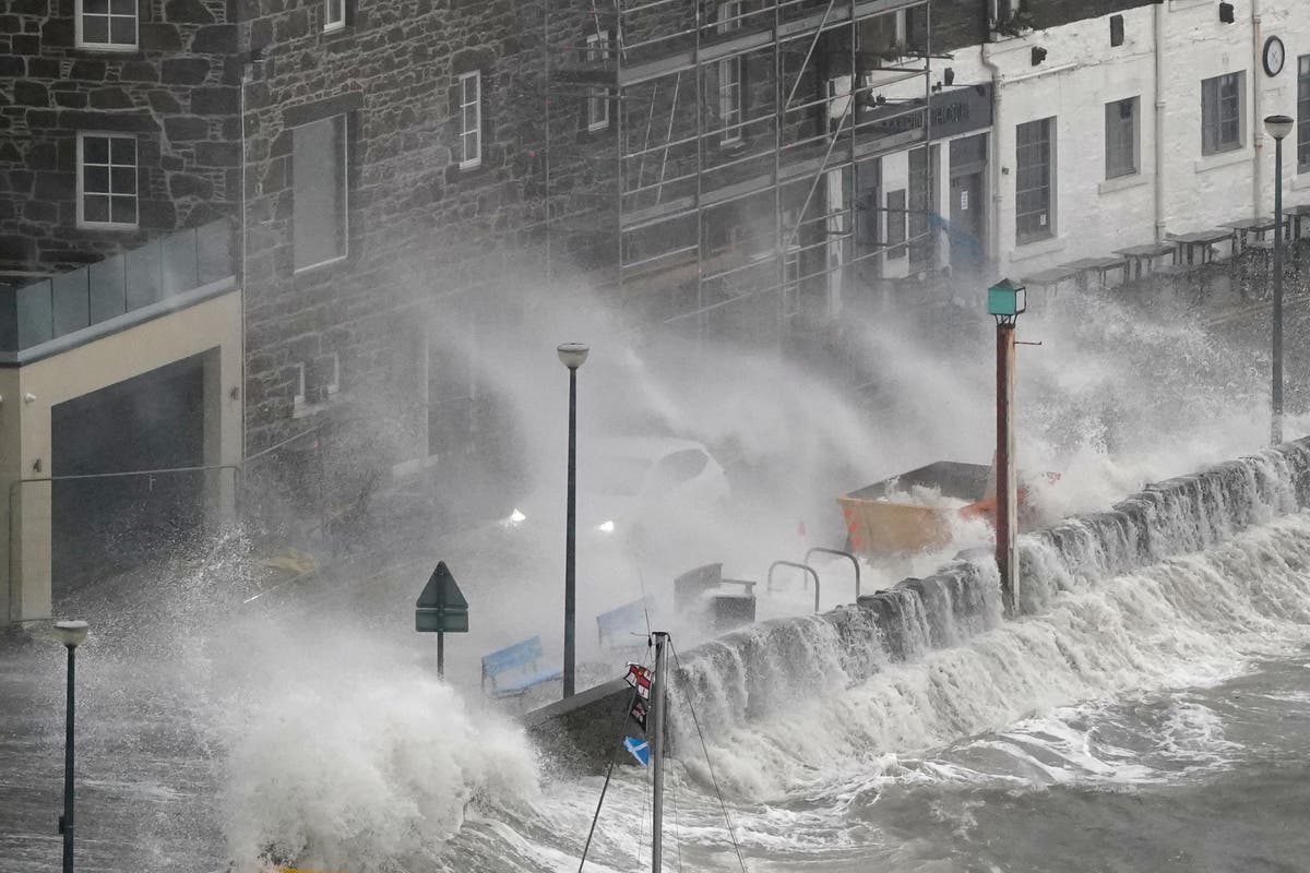
Gusts of 80mph could hit northwest Scotland and “injuries and danger to life is likely from large waves and beach material being thrown onto coastal roads, sea fronts and properties”, the Met Office said.
Forecasters said to brace for power cuts, damage to buildings and disruption for people travelling by road, rail, air and ferry, including road and bridge closures.
Mapped: Where and when are ‘danger to life’ weather warnings in force across UK?
Storm Ashley, the first named storm of the season will initially hit Ireland on Sunday morning, where warnings for strong winds are in force across seven counties, including Galway, Mayo, Kerry and Donegal.
It will then track northeastwards and reach the UK early on Sunday morning, according to the Met Office, bringing with it likely power cuts, damage to buildings and travel disruption. Dozens of flood warnings are also in place.
You can find more details on what to expect in this report:
Storm Ashley mapped: Where are weather warnings in force across the UK?
Met Office is warning of possible damage to homes, power cuts and disruption to travel by air, road, rail and ferry
New weather alert for heavy rain issued in southwest England and south Wales
A further yellow alert for heavy rain has been issued in south Wales, Cornwall, Devon, and parts of Dorset and Somerset between 3am and midday on Sunday.
Between 15 and 25mm of rain is expected to fall in most affected areas. However upslopes exposed to the strong southerly winds could see 35 to 45mm, while potentially as much as 65mm could fall on Dartmoor, the Met Office said.
BBC shipping forecast issues 30 gale warnings
The BBC shipping forecast has issued some 30 gale warnings for locations in the waters around Britain, including near the Hebrides, Dover, the Thames and the Irish Sea.
Violent storm force 11 forecast issued in Shannon, Ireland
The BBC’s shipping forecast is predicting violent storm force 11 in Shannon, Ireland.
On the Beaufort scale used to measure winds, 11 is the second highest reading, behind hurricane-force.
Storm Ashley ‘rapidly developing’ in Atlantic Ocean
Storm Ashley is currently developing rapidly as it moves across the Atlantic, undergoing a process known as “explosive cyclogenesis”, according to the Donegal Weather Channel.
Storm Ashley to bring ‘wet and windy end’ to weekend, Met Office says
Storm Ashley will bring a wet and windy end to the weekend, the Met Office has said, as it published this hour-by-hour forecast of tomorrow’s weather:
ScotRail issue travel advice
Train operator ScotRail also issued advice ahead of expected disruption on Sunday, urging those travelling to check their services are still running.
Scott Prentice, the strategy and planning director at the operator said: “In order to keep our customers and staff safe, speed restrictions will be in place as a precautionary measure on some routes in Scotland, which will mean longer journey times.
“Customers should check their journey before setting off, and keep an eye on our website, app or social media feeds for live updates.”
Orange wind warning extended to more counties ahead of Storm Ashley’s arrival
An orange wind warning has been extended to cover four counties ahead of Storm Ashley’s arrival on the island of Ireland.
Clare and Donegal have been added to the orange alert that initially covered Mayo and Galway.
The warning will be in place from 12pm to 9pm on Sunday.
Met Eireann said the first named storm of the season will bring very strong and gusty south to south-west winds, coupled with high spring tides.
The counties covered could see gusts of up to 130kph.
The forecaster said there was the possibility of coastal flooding, large coastal waves, displacement of loose objects, fallen trees, very difficult travelling conditions, dangerous conditions at sea, damage to power lines and potential power outages, and damage to already weakened structures
The rest of the island is covered by a yellow wind warning.
How is a storm named?
Storm Ashley was named on 18 October as the first storm of the season.
A storm will be named when it has the potential to cause disruption or damage which could result in an amber or red warning.
When the criteria for naming a storm are met, either the Met Office, Met Éireann or KNMI can name a storm, taking the name from the latest list in alphabetical order.
The next five storms will be:
- Bert
- Conall
- Darragh
- Éowyn
- Floris
When will Storm Ashley hit the UK?
Clouds will thicken and wind will strengthen in the early hours of Sunday, and outbreaks of rain will hit Northern Ireland and the west of the UK, Met Office meteorologist Aidan McGivern said.
That rain will be heavy at times and accompanied by gales as the strong winds start, he added.
Western parts of the UK could wake up to 50mph to 60mph winds and heavy rain that day, particularly affecting exposed coasts and hills.
Sunday’s strongest winds will sweep exposed parts of Northern Ireland and western Scotland, with 70mph gusts likely.
They could reach 80mph “or perhaps a fraction more” in parts of western Scotland, Mr McGivern added.
He said: “Those kinds of wind gusts could cause considerable disruption, damage to buildings, transport disruptions of the ferry crossings, for example.
“And also the risk to coastal communities of flooding because these winds coincide with high tides, so that risk is especially great.”
He added that the winds will continue through Sunday and peak in the evening.
Subscribe to Independent Premium to bookmark this article
Want to bookmark your favourite articles and stories to read or reference later? Start your Independent Premium subscription today.
Join our commenting forum
Join thought-provoking conversations, follow other Independent readers and see their replies
Comments