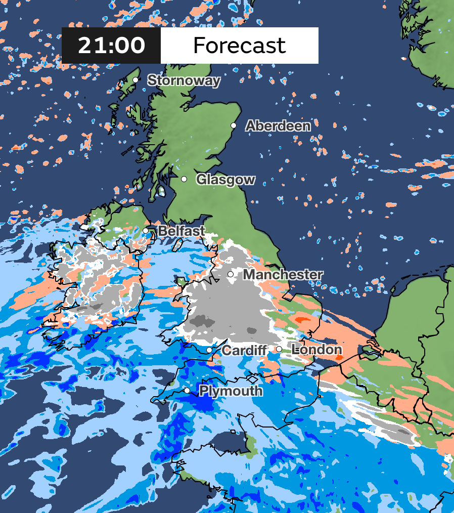
Snow mapped: Where freezing weather will hit UK this weekend with 20-30cm blanket forecast
Most of England, Wales and southern Scotland to see snowfall in first weekend of 2025
Your support helps us to tell the story
From reproductive rights to climate change to Big Tech, The Independent is on the ground when the story is developing. Whether it's investigating the financials of Elon Musk's pro-Trump PAC or producing our latest documentary, 'The A Word', which shines a light on the American women fighting for reproductive rights, we know how important it is to parse out the facts from the messaging.
At such a critical moment in US history, we need reporters on the ground. Your donation allows us to keep sending journalists to speak to both sides of the story.
The Independent is trusted by Americans across the entire political spectrum. And unlike many other quality news outlets, we choose not to lock Americans out of our reporting and analysis with paywalls. We believe quality journalism should be available to everyone, paid for by those who can afford it.
Your support makes all the difference.A three-day snow warning has been issued by the Met Office for much of Britain, with temperatures set to plunge for the first weekend of 2025.
Around 5cm of snow is expected to fall widely across swathes of the Midlands, Wales and northern England, with as much as 20-30cm over high ground in Wales or the Pennines.
The forecasters warned that some could experience power cuts during the 45 hour alert beginning on Saturday, while there is a slight chance that some rural communities could also become cut off.
The warning area covers all of Wales, southern Scotland, and almost all of England – barring parts of the southern and eastern coasts – and will be in place from 12pm on Saturday until 9am on Monday.
Dan Holley, Deputy Chief Forecaster for the Met Office, said: “An Atlantic frontal system is likely to move across parts of central and southern UK through the weekend. With milder, moisture-laden air engaging with the cold conditions already in place this may bring a spell of snow in some areas, before possibly turning back to rain in the south.

“At this stage there is a fair amount of uncertainty over exactly which areas will see disruptive snow, with parts of Wales, northern England and the Midlands most likely to see some impacts. Here we could see 5cm or more in quite a few areas, and perhaps as much as 20-30cm over high ground, including Wales and the Pennines.
“Coupled with strengthening winds this could lead to drifting, making travelling conditions difficult over higher-level routes in particular.”
He added: “We’ve currently issued a Yellow warning for snow covering a large part of England, Wales and southern Scotland to cater for possible disruption over the weekend, but it’s quite likely this will be refined over the coming days as confidence in the forecast increases. So it’s worth keeping up to date with the latest warnings.”

It will come after a cold snap strikes the UK before the weekend, with overnight temperatures dropping as low as -5C in some areas.
It comes as devastating scenes of flooding were seen in Manchester on New Year’s Day, with Greater Manchester Police declaring a major incident. Many were stranded or forced to evacuate from their homes as train lines and major roads were closed following heavy rain overnight.
The start of London’s New Year’s Day Parade was delayed by 30 minutes due to high winds being forecast, and inflatable cartoon characters were not allowed to be used, event spokesperson Dan Kirkby said.

Join our commenting forum
Join thought-provoking conversations, follow other Independent readers and see their replies
Comments