Japan issues alert for ‘violent’ typhoon Hinnamnor
Weather agency warns on Wednesday some houses will ‘collapse’ because of the typhoon
Your support helps us to tell the story
From reproductive rights to climate change to Big Tech, The Independent is on the ground when the story is developing. Whether it's investigating the financials of Elon Musk's pro-Trump PAC or producing our latest documentary, 'The A Word', which shines a light on the American women fighting for reproductive rights, we know how important it is to parse out the facts from the messaging.
At such a critical moment in US history, we need reporters on the ground. Your donation allows us to keep sending journalists to speak to both sides of the story.
The Independent is trusted by Americans across the entire political spectrum. And unlike many other quality news outlets, we choose not to lock Americans out of our reporting and analysis with paywalls. We believe quality journalism should be available to everyone, paid for by those who can afford it.
Your support makes all the difference.Japan’s southern islands are bracing for a super-typhoon, which has already been deemed this year’s strongest one globally and forced authorities to issue an alert to warn residents to evacuate to safer places before it becomes even more dangerous.
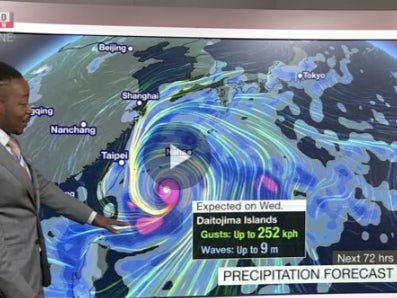
On Wednesday, Japan’s Meteorological Agency said that the typhoon was moving at the speed of 198km per hour (kph) and had gusts of 270kph.
Typhoon Hinnamnor has been classified as “violent,” and is expected to threaten the islands from Wednesday evening through Friday.
The agency says the storm had a central atmospheric pressure of 955 hectopascals.
Meanwhile, Japan Meteorological Agency officials have said that Hinnamnor has been classified as the strongest storm of 2022 based on the maximum sustained wind speed recorded at this point.


It was also reported that the Hong Kong Observatory said at 10 in the morning today that the typhoon was centred about 230 kilometres east of Japan’s Okinawa and is forecast to move west-southwest at about 22 kilometres per hour toward the Ryukyu Islands.
The weather agency warned on Wednesday that because of the typhoon, some houses will “collapse.” It was reported that the super strong winds could destroy houses on Okinawa’s Daitojima islands.
The Philippines is also bracing to face Hinnamnor as it is headed towards the islands off the coast of Japan before turning its attention to the Philippines.
A category 5 super typhoon packs gusts that may reach 320kph.
It was reported that the super typhoon is expected to sustain its strength as it advances west and reaches landfall in the Philippine Area of Responsibility (PAR) on Wednesday evening.
The tropical cyclone will be given the domestic name “Gardo” after it has entered the PAR.
In Japan, in the next 24 hours through Thursday morning, up to 300mm of rainfall is expected. Officials have warned of strong winds and high waves as well.
Join our commenting forum
Join thought-provoking conversations, follow other Independent readers and see their replies
Comments