Mapped: UK braces for two-day washout with over 40 flood warnings in place
Rainfall expected to get heavier and wider over next couple of days
Your support helps us to tell the story
From reproductive rights to climate change to Big Tech, The Independent is on the ground when the story is developing. Whether it's investigating the financials of Elon Musk's pro-Trump PAC or producing our latest documentary, 'The A Word', which shines a light on the American women fighting for reproductive rights, we know how important it is to parse out the facts from the messaging.
At such a critical moment in US history, we need reporters on the ground. Your donation allows us to keep sending journalists to speak to both sides of the story.
The Independent is trusted by Americans across the entire political spectrum. And unlike many other quality news outlets, we choose not to lock Americans out of our reporting and analysis with paywalls. We believe quality journalism should be available to everyone, paid for by those who can afford it.
Your support makes all the difference.Britons have been asked to brace for heavy rainfall over the next couple of days with outbreaks of rain expected over the entire country.
This week has remained unsettled with occasional heavy rains. Showers also hit London with travel chaos, bringing the Paddington station to a halt on Tuesday.
The rainfall is expected to get heavier and wider over the next couple of days with more flood alerts in place.
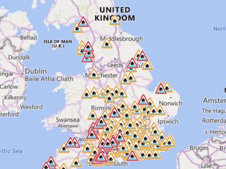
The environment agency has issued 41 warnings for possible flooding and 171 alerts for potential flooding – 40 more than Tuesday.
On Wednesday, northern parts of the UK will experience a slow-moving band of rain, while southern England and Wales can expect drier conditions with mostly cloudy skies.
As this band moves away from Northern Scotland, leaving it with windy conditions and gales, it will cover Scotland, Northern Ireland, Northern England and Wales.
Heaviest rain is expected in Northern England of up to 8mm per hour.
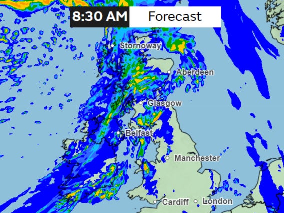
“For much of the country it’s a cloudy start for the day and it’s also wet across Scotland, northern England as well as Wales,” said Met Office meteorologist Clare Nasir.
“The rain clears Northern Ireland through the morning. The central belt is seeing more cloud, but that should clear up as well.”
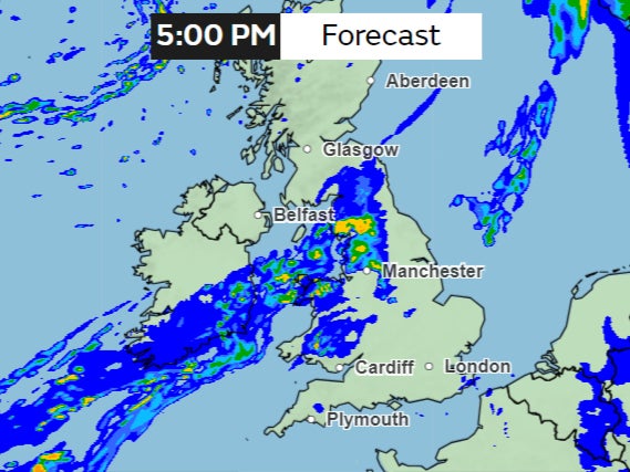
This band of rain is expected to stay longer over northern England and Wales bringing occasionally heavy showers throughout the day.
“So this rain continues to bother northern England, and northern parts of Wales, through Wednesday evening and overnight,” Ms Nasir said.
“And again some heavier pulses can’t be ruled out as it slowly nudges in across southern counties of Scotland, pushing across Northern Ireland as well.”
Further south, there will be some patchy drizzle over the west and some cloud from the Midlands, south Lincolnshire, down towards the southeast.
But the weather will remain exceptionally mild for this time of the year with mercury reaching around 14 or 15C in England, especially in the west.
And for Scotland and Northern Ireland there will be some sunshine through the afternoon.
The trend of rainy weather continues on Thursday, particularly in western regions where heavy rain is expected at times.
However, some fine and dry intervals are forecasted for the southeast. Temperatures are expected to rise gradually through the week.
“And again, some heavier bursts can’t be ruled out through Thursday evening and overnight,” Ms Nasir said.
“This whole system again, pushing north eastwards through Thursday evening, with clearer skies across the far north until much later and into Friday,” she said.
“It’s pretty much showery wherever you are.”
The weekend also brings continued unsettled but mild weather across the UK, the forecast shows. Sunday will see rain clearing eastward, followed by showers, potentially heavy in the west.
Join our commenting forum
Join thought-provoking conversations, follow other Independent readers and see their replies
Comments