UK weather: Met Office issues yellow warnings for heavy rain and strong winds ahead of Storm Babet
Met Office warns of ‘significant and widespread disruption’ this week with arrival of Storm Babet
Your support helps us to tell the story
From reproductive rights to climate change to Big Tech, The Independent is on the ground when the story is developing. Whether it's investigating the financials of Elon Musk's pro-Trump PAC or producing our latest documentary, 'The A Word', which shines a light on the American women fighting for reproductive rights, we know how important it is to parse out the facts from the messaging.
At such a critical moment in US history, we need reporters on the ground. Your donation allows us to keep sending journalists to speak to both sides of the story.
The Independent is trusted by Americans across the entire political spectrum. And unlike many other quality news outlets, we choose not to lock Americans out of our reporting and analysis with paywalls. We believe quality journalism should be available to everyone, paid for by those who can afford it.
Your support makes all the difference.The Met Office has issued several severe weather warnings covering large parts of the UK as Storm Babet is set to batter the country this week with a month’s worth of rain and gale force winds.
The forecaster is warning of “significant disruption”, especially in eastern and central Scotland, where exceptionally high rainfall is expected to hit areas where there is already saturated ground.
The change in weather comes just days after the southern parts of the country were enjoying the Indian Summer sunshine, with the hottest October day in five years recorded in Kew Gardens as temperatures reached 25.8C.
After a settled start, the disruptive weather is expected to become widespread from the middle of the week as wet and increasingly windy conditions moved in from the southwest of England and Wales on Tuesday.
These conditions will spread across the UK through Wednesday, with an area of high pressure over Scandinavia causing fronts to stall over Scotland, which was already battered by heavy rainfall and flooding this month. This stalling is anticipated to lead to persistent heavy rainfall in the region through Thursday and Friday.


From Wednesday onwards, yellow severe weather warnings would cover much of Scotland, eastern Northern Ireland, the northeast of England, Yorkshire, the East Midlands and East Anglia.
The first yellow weather warning will be in place for parts of Northern Ireland from early Wednesday 6am into Thursday as Storm Babet, named by the Met Office on Monday, is forecasted to bring a prolonged period of heavy rain.
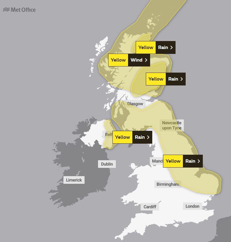
Another warning, which was in place from 9pm on Wednesday and extended until Saturday, covered parts of eastern England, southern Scotland and the Pennines.
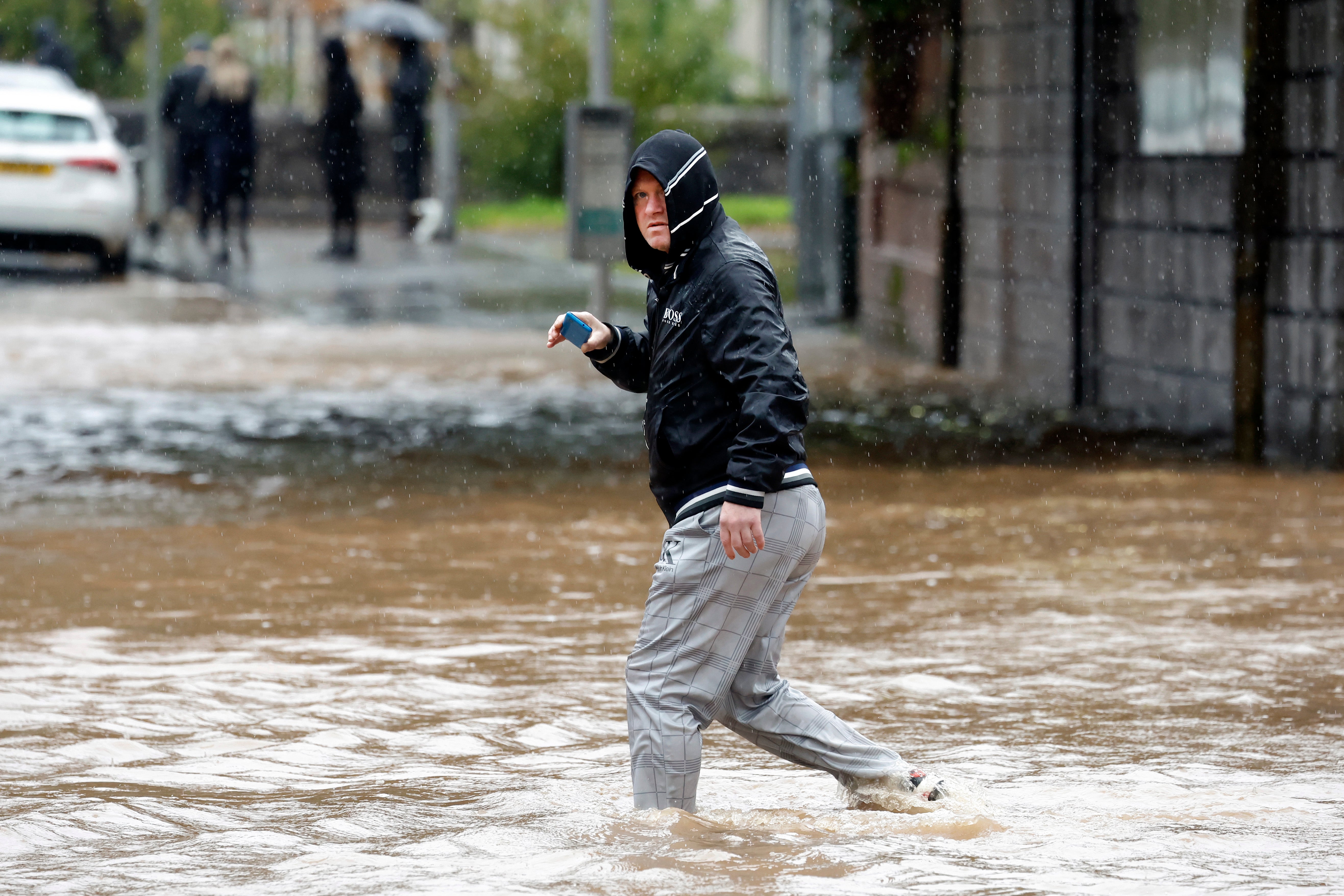
The heavy rain might also cause “fast-flowing and deep floodwater” that could pose a “danger to life”. There was also a chance of essential services such as gas, water and mobile phone signals to be disrupted.
Some parts of Northern Ireland could get up to a month’s worth of rain during the warning period. Parts of England could expect more than 100mm of rainfall during the week with some isolated areas facing up to 150mm.
“Storm Babet will bring impactful rain to many parts of the UK, but especially parts of eastern Scotland, Northern Ireland and northern England later this week,” deputy chief meteorologist Steven Keates said.
“As well as heavy rain, storm Babet will bring some very strong winds and large waves near some eastern coasts too. Gusts in excess of 60mph are possible in eastern and northern Scotland from Thursday,” he said, adding that the Met Office warnings will be updated through the week.
As much as 150mm to 200mm of rain is expected to fall on central and eastern areas of Scotland and there is a possibility of 70mph gale-force winds affecting northern parts of the UK, forecasters warned.
Scotland typically receives 168mm of rainfall in October, but the country will receive more than this in the span of a few days.
“Of particular concern at the moment is eastern and central Scotland where some exceptional rainfall totals could build up, falling on ground already saturated after recent heavy rainfall.”
“This could lead to some significant and widespread disruption."
Weather Outlook
Tuesday: Mostly dry with bright or sunny spells for many regions. Later in the day, it will turn windier from the southwest with rain likely in southwest England and southwest Wales.
Wednesday to Friday: Increasingly unsettled conditions with heavy outbreaks of rain and stronger winds, especially over higher ground. Temperatures will return to average, and milder nights are anticipated.
In its long term forecast for the weekend, the Met Office predicts the start of the period to be “very unsettled across much of the UK”, with parts of northeast Britain expected to experience heavy, persistent rain accompanied by strong to gale force winds.
Further heavy rain and strong winds may also impact parts of southern Britain.
The following week might see a slight reduction in the unsettled conditions, with the driest weather expected in the northeast and wettest conditions likely in the southwest.
Temperatures are expected to remain around average, with fluctuations between milder and colder spells throughout the forecast period.
Join our commenting forum
Join thought-provoking conversations, follow other Independent readers and see their replies
Comments