UK to mark chilly weekend as weather forecast shows when snow will arrive
Britons brace for heavy and ‘possibly thundery downpours with hail’
Your support helps us to tell the story
From reproductive rights to climate change to Big Tech, The Independent is on the ground when the story is developing. Whether it's investigating the financials of Elon Musk's pro-Trump PAC or producing our latest documentary, 'The A Word', which shines a light on the American women fighting for reproductive rights, we know how important it is to parse out the facts from the messaging.
At such a critical moment in US history, we need reporters on the ground. Your donation allows us to keep sending journalists to speak to both sides of the story.
The Independent is trusted by Americans across the entire political spectrum. And unlike many other quality news outlets, we choose not to lock Americans out of our reporting and analysis with paywalls. We believe quality journalism should be available to everyone, paid for by those who can afford it.
Your support makes all the difference.The UK will witness the beginning of a cold and frosty start to the weekend with more showers forecasted by the Met Office with some sunshine.
Parts of the UK saw some continued showers this week but lighter than last week’s rainfall due to Storm Ciarán which led to widespread flooding and travel chaos.
The Met office said early rain and strong winds will clear away from the south and would leave sunny spells and scattered showers on Friday.
The rains would be lighter and less frequent than on Thursday with winds easing in the southwest though remaining breezy.
The easing showers will make way for a “chilly night with patchy fog and frost developing” for the weekend in the UK.
Saturday would mark a dry, bright and chilly start to the weekend with last spells of sunshine turning hazy with clouds thickening from the west as winter sets in.
The weather will remain unsettled on Monday and Tuesday with rain followed by blustery showers, the Met office said.
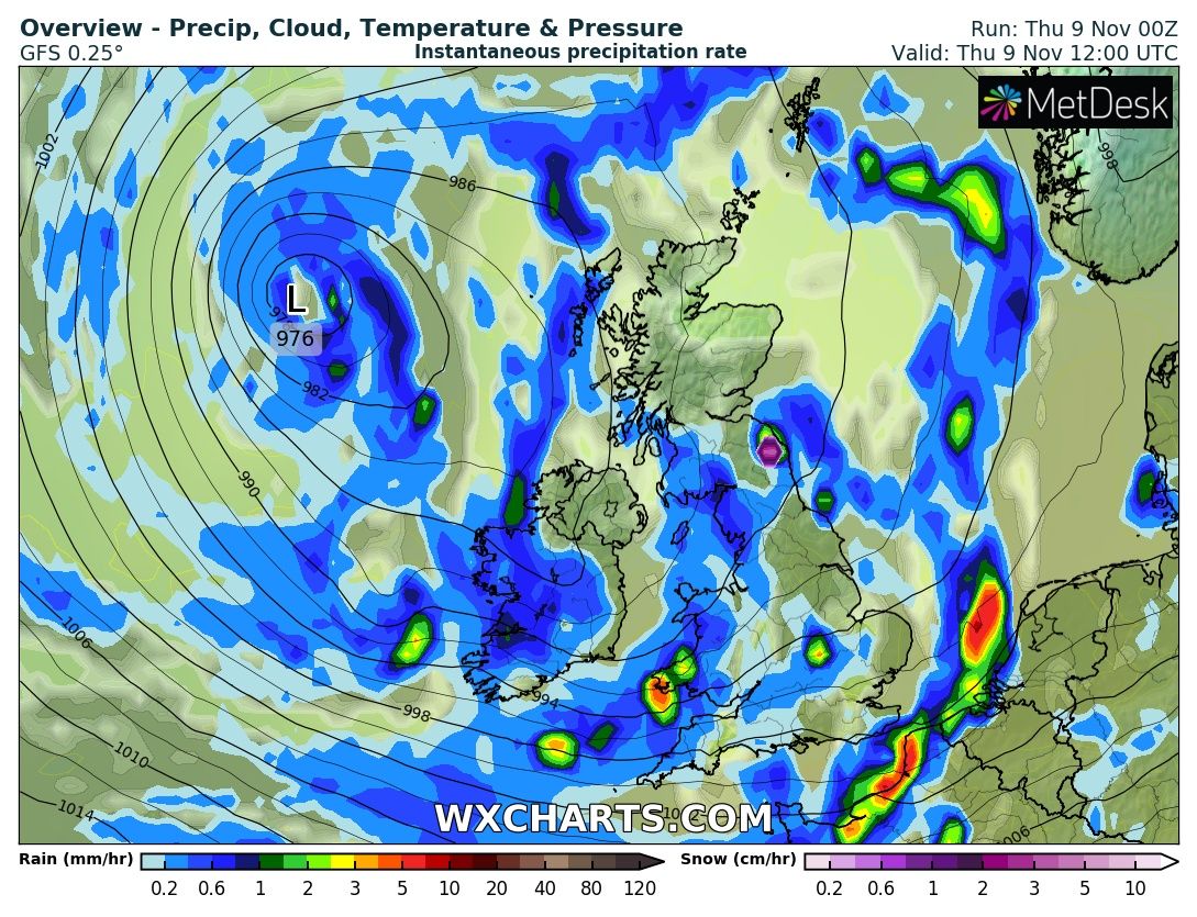
Meanwhile, a UK weather map showed snow is expected to fall in less than two weeks.
The weather forecast from WXCharts, which gets its data from the Met Desk, showed a storm could dip temperatures in the UK, bringing a spell of snow.
A storm originating from the Atlantic is poised to hit the UK within the next ten days, making landfall on 18 November.
However, the pattern of unsettled weather will continue throughout the month, with western and northern areas “seeing the bulk of rainfall,” the Met Office long-range forecast shows.
Rainfall totals will tend to be higher across western areas of the UK, especially coasts and hills, the forecaster says.
Britons can brace for “longer spells of rain” with most of the country interspersed with “very brief drier interludes”.
Temperature will remain close to normal but on the mild side.
“Some overnight patchy frost and fog is possible at times but, overall, the chance of widespread fog and frost is lower than normal,” the forecaster says.
Join our commenting forum
Join thought-provoking conversations, follow other Independent readers and see their replies
Comments