UK weather: Britain braces for thunder, hail and heavy rain as flood warnings issued
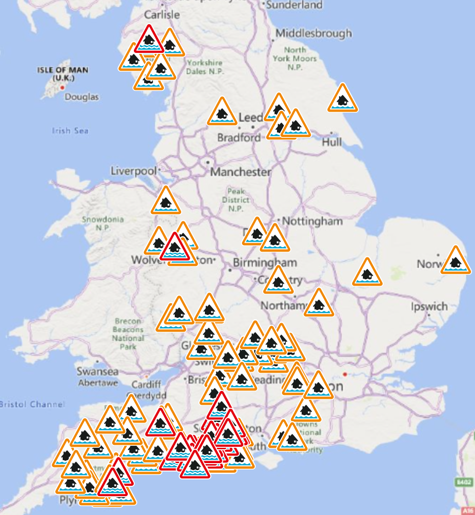
Flood alerts in place in 50 locations across England and Wales
Your support helps us to tell the story
From reproductive rights to climate change to Big Tech, The Independent is on the ground when the story is developing. Whether it's investigating the financials of Elon Musk's pro-Trump PAC or producing our latest documentary, 'The A Word', which shines a light on the American women fighting for reproductive rights, we know how important it is to parse out the facts from the messaging.
At such a critical moment in US history, we need reporters on the ground. Your donation allows us to keep sending journalists to speak to both sides of the story.
The Independent is trusted by Americans across the entire political spectrum. And unlike many other quality news outlets, we choose not to lock Americans out of our reporting and analysis with paywalls. We believe quality journalism should be available to everyone, paid for by those who can afford it.
Your support makes all the difference.The UK is bracing for heavy rain and gale-force winds this weekend, with hail and thunderstorms also possible, forecasters have warned.
Some 50 flood alerts are in force across England and Wales, after an overnight weather warning was issued for heavy and persistent rainfall – with the chance of thunderstorms and hail in the hours ahead.
The Met Office had said that up to 50mm of rain could fall in parts of south Wales, bringing travel disruption and flooding to homes and businesses in its yellow weather alert, which was in force from midnight until 9am on Saturday.
But the threat of flooding remained as the band of rain moved eastwards on Saturday morning – and residents were urged to brace for flooding in 27 locations in England, mostly concentrated in the South West but with pockets also in the Midlands, Lake District, Yorkshire and Shropshire.
People were urged to take “immediate action” in the face of expected flooding near several rivers in Wales, with alerts also issued in 37 places across the country.


Meteorologists said they expected the previous night’s cloud and rainfall to “clear erratically east by early afternoon” on Saturday, with a mixture of sunshine and showers to follow.
However, some of the remaining showers are likely to be heavy, bringing hail and a chance of thunder, the Met Office said.
Temperatures are also set to drop slightly later in the day, although largely remaining mild – with “severe gales” developing in northwest Scotland on Saturday night.
Met Office forecaster Alex Deakin said the weather front approaching from the west “will bring many of us a wet start to the weekend”, with “a lot of cloud and outbreaks of rain around”, adding: “Some parts across the far southeast and far northeast may stay soggy until dusk”.
Showers coming in from the west will “zip through because of the strength of the wind”, he said, adding that temperatures will be “a notch down” on Saturday – starting at around 10C in the morning before “dipping off” in the afternoon.
Sunday will be colder, with temperatures returning to near average, accompanied by sunshine and showers, organised into bands and heavy at times, according to the Met Office. While it will remain windy, the severe gales are expected to ease from northwest Scotland during the morning.
Join our commenting forum
Join thought-provoking conversations, follow other Independent readers and see their replies
0Comments