UK weather: Thunderstorms, lightning and heavy rain as Met Office issues new warning
Large parts of UK face downpours with the risk of flooding, Met Office warns

Your support helps us to tell the story
From reproductive rights to climate change to Big Tech, The Independent is on the ground when the story is developing. Whether it's investigating the financials of Elon Musk's pro-Trump PAC or producing our latest documentary, 'The A Word', which shines a light on the American women fighting for reproductive rights, we know how important it is to parse out the facts from the messaging.
At such a critical moment in US history, we need reporters on the ground. Your donation allows us to keep sending journalists to speak to both sides of the story.
The Independent is trusted by Americans across the entire political spectrum. And unlike many other quality news outlets, we choose not to lock Americans out of our reporting and analysis with paywalls. We believe quality journalism should be available to everyone, paid for by those who can afford it.
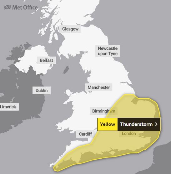
Your support makes all the difference.Parts of the UK are being hit by thunder, lightning and heavy rain as the Met Office issues a new weather warning.
The warning is in place until 10pm on Tuesday, and covers much of southern England, East Anglia, and parts of the Midlands.
The Met Office said that “heavy showers and thunderstorms likely to cause some disruption to travel”.
It added that there could be some damage to property caused by flooding.
Met Office spokesperson Stephen Dixon said: “What we see today is some heavy showery rain moving eastward across southern areas that UK.”
“Some of these showers can be quite heavy in nature and and come with associated hail and thunder and lightning for a time as well.”
He said that some parts of the yellow warning area could see 40 millimetres of rain over a three hour period.
“Within this warning area the showers gradually release through the day.
“Some places could see 20 millimetres of rain within an hour, and some places could also see in excess of 40 millimetres over a three-hour period.”

He said that the unsettled weather would continue “for much of the week”.
“On Wednesday, we’ve got low pressure approaching the north-west of Scotland, which is going to introduce some more wet weather, particularly in the west of Scotland and Northern Ireland for a time.”
On Thursday, widespread showers could again be quite heavy.
“Widespread showers are possible on Thursday and some of the showers again could be quite heavy in nature for a time,” he said.
However, he said that the public could expect a “drier” day on Friday.
“Generally, a drier day for many on Friday, albeit largely quite cloudy for many,” he added.

MET OFFICE OUTLOOK
Tuesday evening
Heavy showers and thunderstorms across southeast England only slowly clearing. Mostly dry elsewhere with clear spells and a few fog patches, before showers across northwestern areas become more frequent later.
Wednesday:
A mixture of sunny spells and showers across most parts; some of the showers heavy with hail and thunder in some places. Breezy in the south and west.
Outlook for Thursday to Saturday:
A widely showery day on Thursday, with some heavy, thundery downpours in places. Showers becoming more restricted to southern areas on Friday, with most places largely dry on Saturday.


Join our commenting forum
Join thought-provoking conversations, follow other Independent readers and see their replies
Comments