UK weather: Flooding fears after 80mm of rainfall as strong wind warning issued by Met Office
Forecasters concerned about more flooding as heavy rain set to continue into weekend after week of downpours
Your support helps us to tell the story
From reproductive rights to climate change to Big Tech, The Independent is on the ground when the story is developing. Whether it's investigating the financials of Elon Musk's pro-Trump PAC or producing our latest documentary, 'The A Word', which shines a light on the American women fighting for reproductive rights, we know how important it is to parse out the facts from the messaging.
At such a critical moment in US history, we need reporters on the ground. Your donation allows us to keep sending journalists to speak to both sides of the story.
The Independent is trusted by Americans across the entire political spectrum. And unlike many other quality news outlets, we choose not to lock Americans out of our reporting and analysis with paywalls. We believe quality journalism should be available to everyone, paid for by those who can afford it.
Your support makes all the difference.Fears have been raised of further flooding in the UK, after 80mm of rain fell in less than 14 hours and more downpours on the way.
South West England and Wales have been hit by torrential rain over the last 24 hours, with rivers overflowing and roads closed due to rising waters.
And now the Met Office has issued a new warning for strong winds, going into Friday morning.
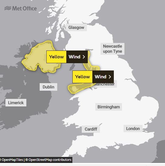
The forecaster told The Independent Maerdy in south Wales saw 80mm of rainfall between 9pm on Wednesday and 10.30am Thursday morning.
Nant yr Ysfa experienced 75mm at the same time, while West Dunkery and Black Pitts in the south west of England had 60mm and 50mm respectively.


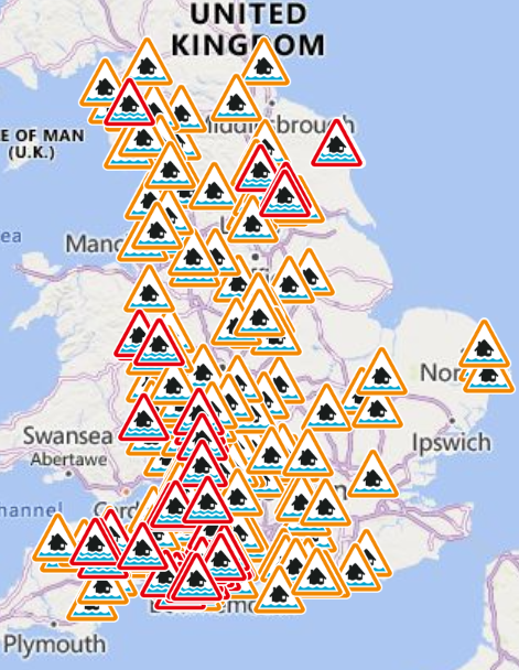
Flood warnings are still in place across large parts of the UK and the wet weather could also lead to power cuts and the loss of other services to homes and businesses. As many as 20 flood warnings are in place across Wales as roads have been submerged and people are being urged not to drive.
The River Taff has overflowed into Bute Park in Cardiff and areas like the Taff Trail, Blackweir and Pontcana Fields were underwater.
There are 43 flood alerts in place across the country, pinpointing areas where flooding is possible.
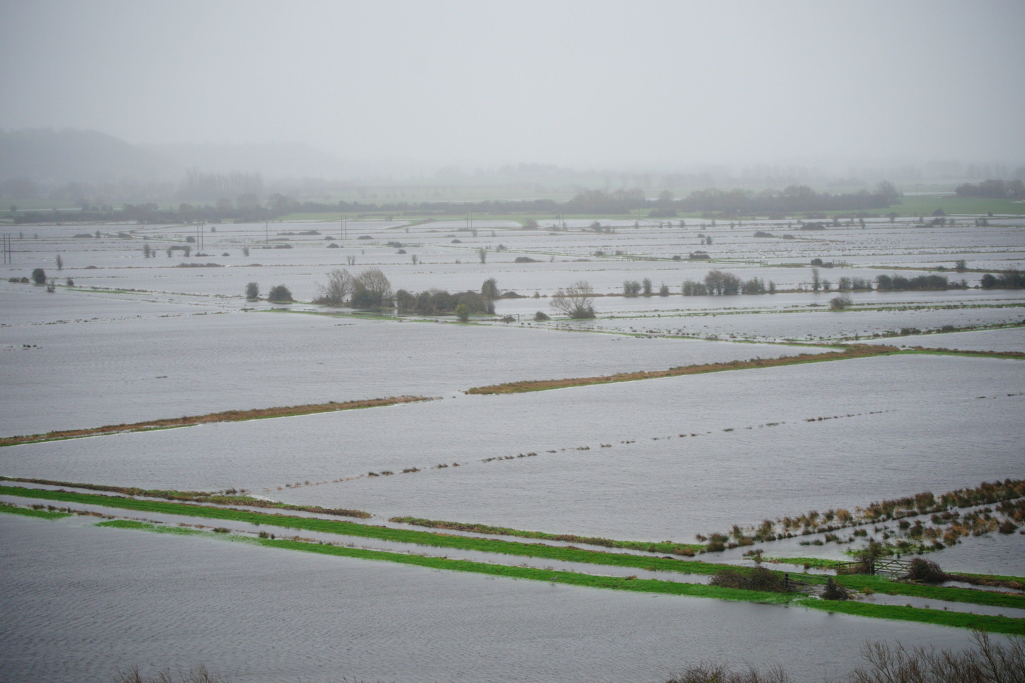
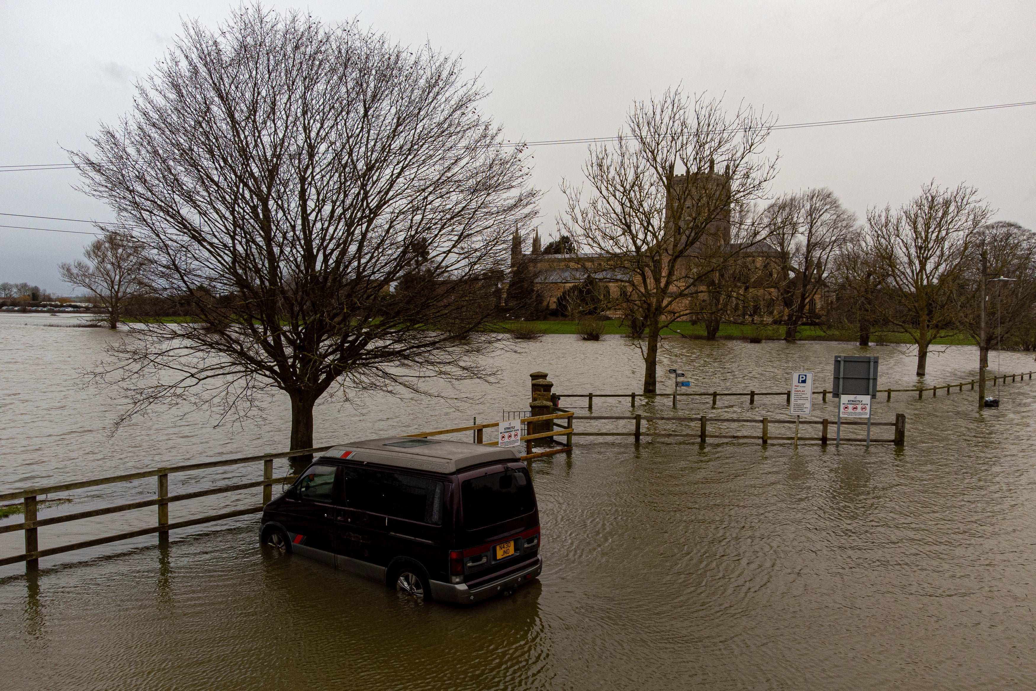
Tewkesbury in Gloucestershire has been hit by serious flooding, as has a lot of the county of Somerset.
The A361, a major road in Somerset, has finally reopened after flooding following the council’s decision to close it over concerns it would flood even more severely.
And Weston-super-Mare’s historic Birnbeck Pier has suffered damage in the storm with more of it crumbling and falling into the sea. Part of the decking of the pier has fallen into the sea after being battered by the bad weather.
Train services have also been affected in parts of the South Wst due to speed restrictions being brought in because of the heavy rain.
Passengers on Great Western Railway services between Okehampton and Exeter, for example, have been told to expect delays and disruption “until the end of the day”.
While Friday will see a brief respite from the rain, more heavy rainfall is to come.
By late on Friday, the next period of rainfall looks to be setting in, according to the Met Office. Its forecast expects the wet weather to hit the north west of England, Wales and Scotland before spreading everywhere.
Saturday will see more rain, accompanied by gusty winds, and up to 50mm of rainfall could fall. This will gradually move east on Saturday, making for a showery day on Sunday. Some precipitation could fall as snow on Sunday in Scotland.
Speaking in the Met Office 10-Day Trend, Meteorologist and Presenter Aidan McGivern said: “With all that wet weather coming in, there are concerns, particularly for those areas that have already seen so much rain across western England and Wales. The wettest weather is likely to see 60-80mm falling across the Brecon Beacons and Exmoor.”
Temperatures are also expected to slowly drop from the weekend into next week.
“These showers from the north could fall as snow over the high parts of Scotland, northern England and Northern Ireland later in the weekend, and as we move through next week often below average temperatures could support a mixture of rain, hail sleet and snow,” Mr McGivern added.
“Most of any snow accumulation is likely over higher parts of the northern UK.”
MET OFFICE OUTLOOK
Thursday evening:
Cloud and rain will clear the southeast with some clear spells following. Scattered showers elsewhere, frequent and merging into longer spells of rain at times in the northwest. Gales affecting Northern Ireland at first, then north Wales and northern England.
Friday:
Showers become increasingly confined to some northern areas, with longer sunny spells developing for much of the south. Despite this a chillier day overall, emphasised by a continuing brisk breeze.
Saturday to Monday:
Rain clearing east on Saturday, with colder, predominantly showery conditions following. Showers will increasingly fall as snow in the north, even to lower levels. Windy for many areas.
Join our commenting forum
Join thought-provoking conversations, follow other Independent readers and see their replies
Comments