Thunderstorms set to hit UK as Met Office gives verdict on ‘September heatwave’
A Met Office spokesperson says the UK could see temperatures in the ‘high 20s’ in September
Your support helps us to tell the story
From reproductive rights to climate change to Big Tech, The Independent is on the ground when the story is developing. Whether it's investigating the financials of Elon Musk's pro-Trump PAC or producing our latest documentary, 'The A Word', which shines a light on the American women fighting for reproductive rights, we know how important it is to parse out the facts from the messaging.
At such a critical moment in US history, we need reporters on the ground. Your donation allows us to keep sending journalists to speak to both sides of the story.
The Independent is trusted by Americans across the entire political spectrum. And unlike many other quality news outlets, we choose not to lock Americans out of our reporting and analysis with paywalls. We believe quality journalism should be available to everyone, paid for by those who can afford it.
Your support makes all the difference.Thunderstorms are set to hit parts of the UK this week - before the country looks set for spells of “very warm weather” later in the month.
But reports of a record-breaking September heatwave look to be far-fetched, according to the Met Office.
When asked if the mercury could reach highs of 30C, a spokesperson said: “There’s no truth in it at all.
“This week we could see temperatures climb again towards the back end of the week to Friday and Saturday, but it’s not going to get anywhere near what’s been quoted,” the spokesperson said.
“We may get towards the high 20s, maybe a 27, possibly a 28. But it’s not looking likely that we’re going to see any sort of record temperatures. There’s nothing I can see from our data [to indicate that].”
But in a long-range forecast, the Met Office did say that there is potential for “brief spells of warm or even very warm weather” during September.
“Temperatures are likely to be around average overall, with further potential for brief spells of warm or even very warm weather in the south, especially southeast, at times,” the forecast for read for 7 September to 16 September.
In the shorter term, a yellow weather warning was issued by the Met Office covering large parts of the UK, during which up to 80mm of rain may fall in the worst affected areas in eastern Scotland.
The warning for thunderstorms, which was in place all day Monday until midnight, covered central and northern England, a large part of Scotland and all of Wales.
Some affected areas were set to see 40mm of rainfall in less than an hour as well as lightning strikes, hail and a risk of flash flooding, the forecaster said.
As of Monday afternoon, the Environment Agency had 14 flood alerts in place – meaning flooding is possible.
The alerts covered areas in central England including Bottle Brook in Derbyshire, the River Blyth in Warwickshire and the River Maun in Nottinghamshire.
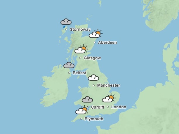
And on Tuesday, the wet weather is forecast to continue for many with rain in the south east, plus showers in the north and west. “Generally feeling cooler and fresher [across the UK],” said a spokesperson.
The forecast for Wednesday is “sunshine and showers”, with most rainfall concentrated in England and Wales accompanied by a small chance of thunder and highs of 24C in south-east England.
Conditions for the remainder of the week look “unsettled” with further outbreaks of rain and thunder in southern England looking likely, the Met Office said.
It comes as initial statistics suggest that the UK has had its “coolest summer” since 2015. According to provisional Met Office statistics, the mean daily temperature (the average across 24 hours) was 14.37C – 0.22C below average.
But the forecaster pointed out that 14.37C would still be considered warmer than average if compared with 1961-1990, when the figure was 13.78C.
Met Office scientist Emily Carlisle said: “While this summer may have felt cool compared to recent years, it’s important to note where it sits in a historical context, with the changing climate of the UK increasing the frequency of warmer summers, as can be observed through our observations.
“While climate change increases the frequency of warmer weather in the UK, our natural variability means that we’ll still experience cooler than average summers at times.”
Join our commenting forum
Join thought-provoking conversations, follow other Independent readers and see their replies
Comments