New yellow weather warning issued as Britain braces for ‘cold snap’
Met Office warns daytime temperatures could go down by about 10C in coming days
Your support helps us to tell the story
From reproductive rights to climate change to Big Tech, The Independent is on the ground when the story is developing. Whether it's investigating the financials of Elon Musk's pro-Trump PAC or producing our latest documentary, 'The A Word', which shines a light on the American women fighting for reproductive rights, we know how important it is to parse out the facts from the messaging.
At such a critical moment in US history, we need reporters on the ground. Your donation allows us to keep sending journalists to speak to both sides of the story.
The Independent is trusted by Americans across the entire political spectrum. And unlike many other quality news outlets, we choose not to lock Americans out of our reporting and analysis with paywalls. We believe quality journalism should be available to everyone, paid for by those who can afford it.
Your support makes all the difference.Britons are being warned to brace for a sudden dip in temperatures this week as heavy wind and rain bring the first cold snap of the season.
The Met Office has warned that the temperatures could plunge in the coming days after the extended Indian summer saw warm weather get pushed to October.
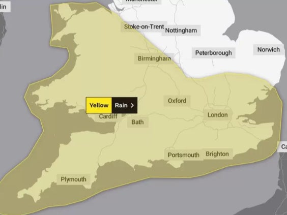
A new yellow weather warning was issued for southwest Britain from 9pm on Thursday until the end of Friday.
The forecaster said 20-30mm (0.8-1.2inches) of rain could fall in two hours.
Rain is expected to spread across much of the country on Friday with occassional heavy showers in places, but still some sunny spells are predicted.
The wet weather comes as rainy clouds that battered Scotland this week and prompted flash floodings and dramatic rescues, spread across the central and southern parts which had been basking in unseasonal sunshine in a major contrast.
However, the first “cold snap” of the season is set to take over much of the country by this weekend.
“All parts of the UK will turn much cooler by the weekend, with daytime temperatures potentially up to 10C colder than earlier this week across southern England,” the Met Office said in a release.
The first widespread overnight frost of the season is also likely across many central and northern areas over the weekend, the forecaster said, adding that there will be some heavier and more frequent showers for Scotland once again with some snow likely for the Scottish mountains.

“As we head through the second half of this week, cold air will push southwards across the country and there is a risk that showers over mountains of Scotland could turn wintry,” Met Office deputy chief meteorologist Brent Walker said.
“By the weekend we expect all regions of the UK to be in the cold air mass and overnight frosts are possible.”
“With high pressure continuing to dominate our weather early next week, it will start largely fine, settled and cool by day, with cold nights and a risk of rural air frosts in places.
“Any early morning mist or fog should clear quickly and there could be a few showers possible around some coasts at times.”


Join our commenting forum
Join thought-provoking conversations, follow other Independent readers and see their replies
Comments