UK weather mapped: More flood alerts issued as Britons brace for heavy rains
Rainfall dominates forecast for this week with unsettled conditions expected to continue

Your support helps us to tell the story
From reproductive rights to climate change to Big Tech, The Independent is on the ground when the story is developing. Whether it's investigating the financials of Elon Musk's pro-Trump PAC or producing our latest documentary, 'The A Word', which shines a light on the American women fighting for reproductive rights, we know how important it is to parse out the facts from the messaging.
At such a critical moment in US history, we need reporters on the ground. Your donation allows us to keep sending journalists to speak to both sides of the story.
The Independent is trusted by Americans across the entire political spectrum. And unlike many other quality news outlets, we choose not to lock Americans out of our reporting and analysis with paywalls. We believe quality journalism should be available to everyone, paid for by those who can afford it.
Your support makes all the difference.Large parts of the UK are set for an unsettled week with persistent rain and drizzle continuing for many.
The Met Office predicts ongoing outbreaks of rain and drizzle throughout the country with occasional dry spells.
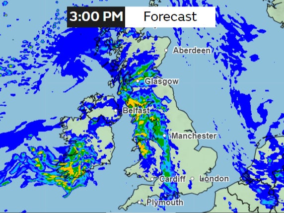
Tuesday will start with a band of heavy rain entering from the west and moving eastward, according to the latest forecast.
Rain is expected to blanket the entire country on Tuesday morning, with intensifying downpours at times.
Although heavy rain will gradually clear towards the east as the day progresses, the afternoon will remain overcast, with the possibility of light rain persisting.
The western regions are also expected to face increasing winds as the day unfolds.
This unsettled pattern will continue through the week and longer, the forecast shows.
While some reports show another “snow bomb” expected to blanket the UK in the coming days, based on WXCharts, the Met Office long-range forecast only shows “a broadly unsettled pattern” continuing into the next weekend, with showers and brighter spells.
Some 41 flood warnings have been issued by the environment agency and there are 129 less severe flood alerts. There are no Met Office severe weather warnings in place for now.
Despite the unsettled weather, temperatures are expected to remain above freezing under the blanket of clouds.

Cloudy conditions will persist into the evening, accompanied by light rain in the west initially.
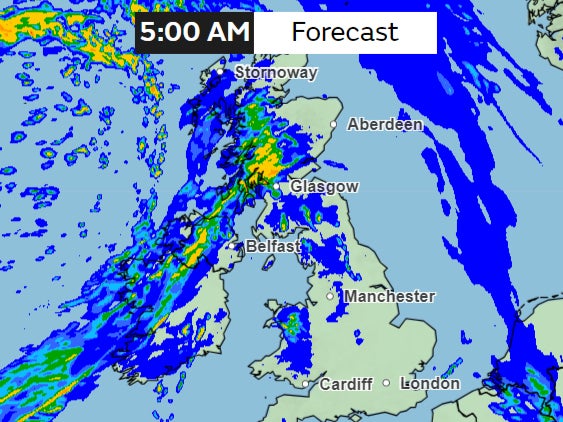
However, the weather is expected to turn for the worse as the night progresses.
Outbreaks of rain will become heavier and sustained, particularly affecting Northern Ireland and Scotland as a band of rain enters from the north.

This band will slowly move across northern parts of the UK on Wednesday. Southern England and Wales are expected to experience drier conditions, although the day will remain predominantly cloudy.
Wednesday is largely set to be a windy day, with gales expected in northern Scotland.
The rainfall will continue this week, particularly in the west where it will be heavy at times.
However, residents in the southeast may enjoy periods of fine and dry weather. As the week progresses, temperatures are expected to rise, bringing milder conditions across the country.
Join our commenting forum
Join thought-provoking conversations, follow other Independent readers and see their replies
Comments