Mapped: Rain set to lash parts of UK this weekend
Showers set to turn heavier on Sunday
Your support helps us to tell the story
From reproductive rights to climate change to Big Tech, The Independent is on the ground when the story is developing. Whether it's investigating the financials of Elon Musk's pro-Trump PAC or producing our latest documentary, 'The A Word', which shines a light on the American women fighting for reproductive rights, we know how important it is to parse out the facts from the messaging.
At such a critical moment in US history, we need reporters on the ground. Your donation allows us to keep sending journalists to speak to both sides of the story.
The Independent is trusted by Americans across the entire political spectrum. And unlike many other quality news outlets, we choose not to lock Americans out of our reporting and analysis with paywalls. We believe quality journalism should be available to everyone, paid for by those who can afford it.
Your support makes all the difference.Rain is set to lash parts of the UK this weekend, bringing an end to the dry spell enjoyed by many this week.
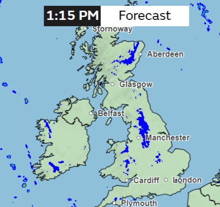
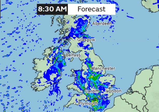
Weather maps from the Met Office show unsettled weather from Friday with some drizzle, while Sunday could bring heavier showers to large parts of the country.
Thursday will start largely dry with fog and frost clearing to sunny spells, but some showers in the south and northeast are expected, the forecaster said.
The south could see some “heavy showers” while the northeast will “hold on to low clouds with some showers”.
Friday is again expected to be mostly dry and bright in the south, with patchy rain further north.

However, the forecaster said the conditions are “turning more unsettled over the weekend” with rainy and windy weather.
There will be “outbreaks of rain, sometimes heavy”.
The rainfall forecast map from the Met Office shows a band of rain moving into the country on Sunday with heavier showers in the south.

There are no weather warnings in place currently.
The change to more unsettled conditions comes after a few days of drier and more settled weather following weeks of heavy rainfall in February.
“A marked temperature contrast starts to form through Wednesday, Thursday and Friday,” Met Office meteorologist Aidan McGivern said.
“We’re going to see 6-7C and a brisk wind coming in from the North Sea.”
But after Sunday’s brief wet spell, the weather is again expected to become drier and warmer, the Met Office confirmed on Wednesday, dismissing reports of “snow bomb”.
In a statement to The Independent, a Met Office spokesperson clarified that any snow-related disruption next week “looks unlikely”.
“Mainly dry conditions developing for most areas at the start of next week”, the Met Office forecast says.
“It will probably stay drier and brighter across the north, although still with a few showers in places.”

Join our commenting forum
Join thought-provoking conversations, follow other Independent readers and see their replies
Comments