Cornwall's Saints' Way: Go beyond the beach on this walking route
Simon Calder enjoys a spiritual superhighway and discovers a different side to the county once known as Kernow

Your support helps us to tell the story
From reproductive rights to climate change to Big Tech, The Independent is on the ground when the story is developing. Whether it's investigating the financials of Elon Musk's pro-Trump PAC or producing our latest documentary, 'The A Word', which shines a light on the American women fighting for reproductive rights, we know how important it is to parse out the facts from the messaging.
At such a critical moment in US history, we need reporters on the ground. Your donation allows us to keep sending journalists to speak to both sides of the story.
The Independent is trusted by Americans across the entire political spectrum. And unlike many other quality news outlets, we choose not to lock Americans out of our reporting and analysis with paywalls. We believe quality journalism should be available to everyone, paid for by those who can afford it.
Your support makes all the difference.Half-a-million holidaymakers will wake up this morning in Cornwall. Most will spend their day filling the county's beaches, drinking at waterside pubs or exploring rock pools along its crinkled coast. Yet anyone prepared to turn their back on the ocean can find a fascinating trail across the plump Cornish waist from sea to shining sea.
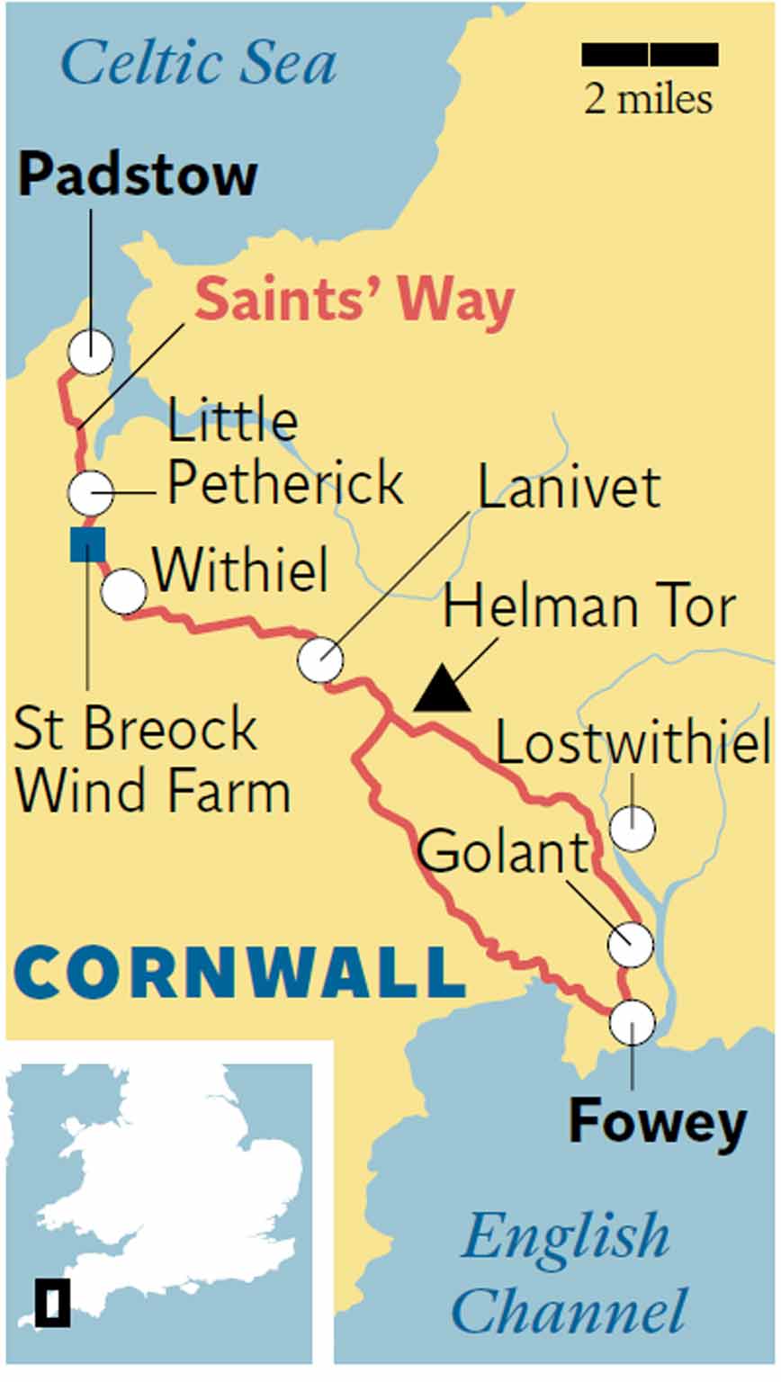
To understand the Saints' Way, consider the flag of Cornwall (or Kernow, to give it its Gaelic name): a white cross on a black background. If the long horizontal stripe represents the spine of Britain's south-westernmost county, the short vertical line in the middle signifies an ancient holy pathway between the north coast and south. It begins in Padstow, an implausibly pretty fishing port where shoals of tourists swish through the streets. The 30-mile walk ends in Fowey – ditto.
The name may suggest it is a single, well-trodden path that once acted as a spiritual short-cut if going from Wales or Ireland to Rome. Certainly, some of the missionaries who flowed between the hub of Christianity and the Celtic lands 14 centuries ago crossed the spine of Cornwall to avoid the treacherous seas off Land's End. The link between Padstow and Fowey was later used by pilgrims to the great shrines in France and Spain. But the present incarnation of the Saints' Way is a 1968 construct, a clever piece of cartographical embroidery that combines public rights-of-way and a few stretches of country roads with the sunken lanes used by drovers to connect the coasts. Today, sheep and cattle are likely to outnumber humans. So, you can enjoy in splendid isolation the almost-constant loveliness of Cornwall's interior.
The first half-mile south from Padstow harbour explains the "almost"; the Saints' Way cuts through a housing estate. Soon, though, rural life supplants suburbia: shady pathways guarded by thistles and punctuated by granite stiles, fields strewn with daisies and a sequence of viewpoints to lift the spirits. First up is Dennis Hill, where a monument commemorates Queen Victoria's first 50 years on the throne. The obelisk peers down on Camel River estuary and the woods that cling to its shores. Then you settle into a rhythm, breezing across meadows and zig-zagging down to a rickety river crossing.

At Little Petherick, you cross a creek on a proper road, then set your sights on a target that looms 600ft higher on the horizon: St Breock Wind Farm. A handy beacon; while the Saints' Way signposting, using a Celtic cross as the motif, is mostly fine, it takes only one missing symbol to trigger a frustrating diversion. Four miles' slog later, you reach the army of spindles, each with three slender foils to harvest the energy from the wind that sweeps across the county. To the north-east, a swathe of lavender does a deep-lilac impression of Provence. To the south-east, on downland flecked with wildflowers, a mighty 16 ton standing stone points towards the heavens.
Shed altitude down to a picturesque ford at the River Ruthern, then climb steeply to Withiel and its charmingly titled Coddles Mill. Cross the Old Coach Road towards Bodmin; Thomas Hardy visited here in 1872, and wrote of "the solitude of the moor". But a rumble of traffic impinges from the A30 half-a-mile south, the route for 21st-century pilgrimages.
Even Saints need refreshment, and the pub at the walk's midway point, and Cornwall's geographical centre, is the Lanivet Inn. The pub sign shows a giant panda, because in 1938, when pandas first arrived at London Zoo, local Boy Scouts were despatched to a nearby bamboo grove to forage for them. Close by, the churchyard contains a 13th-century Celtic cross.
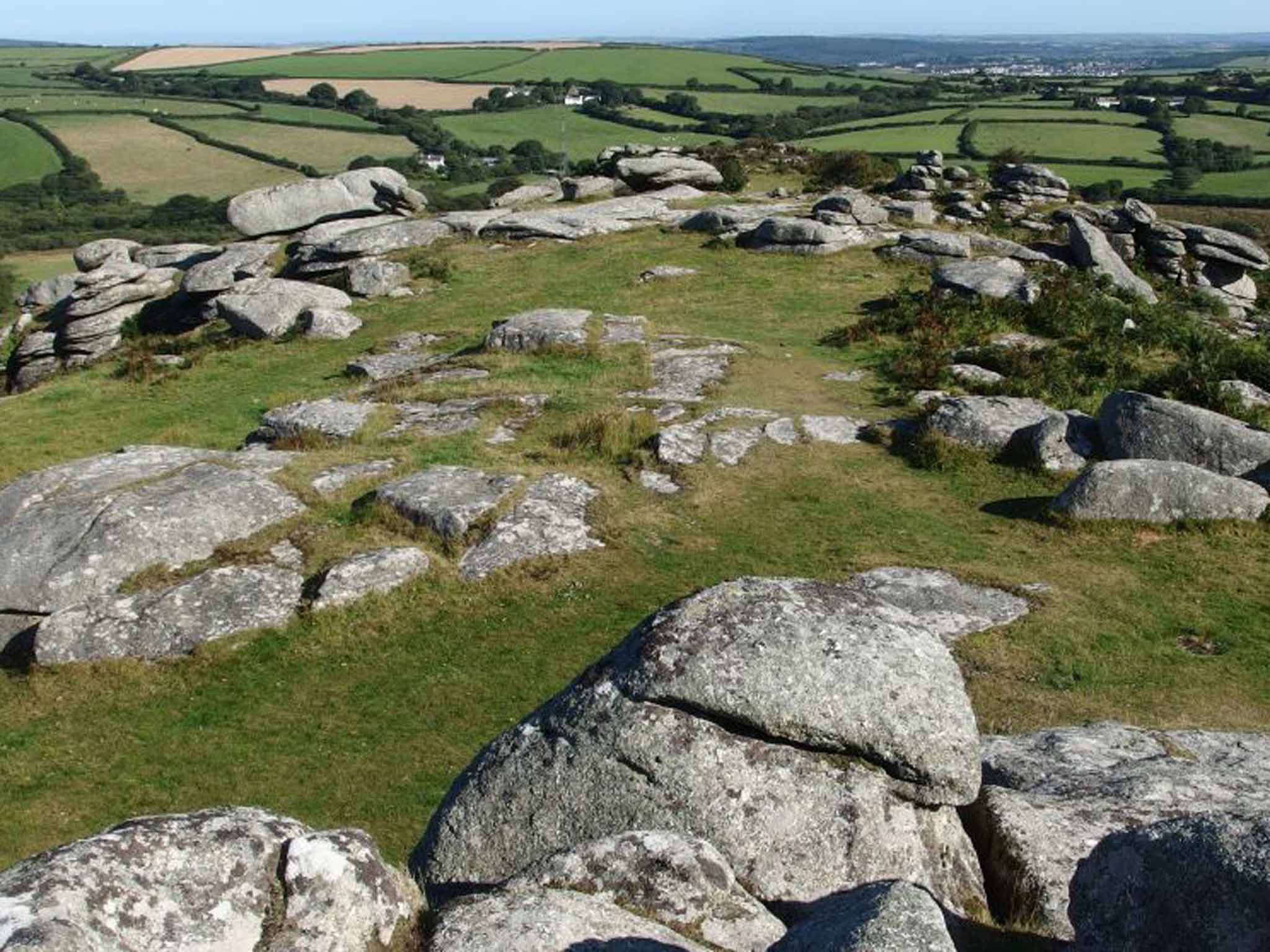
Barely a mile from the current London-Land's End highway, the Saints go marching in different directions as the trail splits, east and west. I have tried both; east is best by a country mile. It leads past Helman Tor, the perfect pivot for the walk. The 680ft hill supports the remains of a Neolithic hut circle that resembles a slapdash Stonehenge. You can see the Celtic Sea to the north and the Channel to the south.
The path cuts through wheat fields and woodland above the Fowey River, then dips to the pretty riverside hamlet of Golant. whose churchyard is thick with Celtic crosses. Stealthily, the landscape becomes industrial: a freight line carries China clay trains, and Sawmill Creek reflects the shipbuilding heritage that began in the 17th century. The approach to Fowey takes you past handsome station buildings that were left to rot when the railway closed in 1965, and thousands of bats took charge. The station is being converted into "a bespoke collection of apartments and duplexes", but a new bat sanctuary has been built, and it looks like a Scandinavian sauna.
Pause by the old Post Office – now Scallop Shell House, with a pilgrim's shell above the main door signifying the status of spiritual superhighway. Five minutes later, you reach the official end of the Saints' Way, the church of St Fimbarrus, a sixth-century missionary. The pulpit is said to be made from the cabin timbers of a captured Spanish galleon.
For a more satisfying conclusion, continue south to Readymoney Cove, a classic Cornish notch in the coast, with those summertime essentials of a sandy beach, rock pools and an ice-cream van.
Getting there
Neither end of the route has rail access but both have bus links to mainline stations: Padstow from Bodmin Parkway, Fowey from Par. Both stations are on the line between Plymouth and Penzance, with services to Birmingham, Bristol, Cardiff, Exeter, London and many other stations on First Great Western and CrossCountry Trains. Call 08457 48 49 50 or visit nationalrail.co.uk for schedules and fares.
Staying there
In Lanivet, the halfway point of the Saints' Way, St Benet's Abbey (01208 831352; stbenetsabbey.co.uk) is a 15th-century B&B. A standard double room costs £82, including breakfast.
More information
The Saints' Way, by Heulyn and Ginny Lewis, Pelican Studio (£4.99) is a well-written and designed collection of route cards.
See also visitcornwall.com/saints-way
Join our commenting forum
Join thought-provoking conversations, follow other Independent readers and see their replies
Comments