Nasa scans reveal abandoned city buried under ice in Greenland
Method can help scientists measure ice sheet thickness in similar environments like Antarctica
Your support helps us to tell the story
From reproductive rights to climate change to Big Tech, The Independent is on the ground when the story is developing. Whether it's investigating the financials of Elon Musk's pro-Trump PAC or producing our latest documentary, 'The A Word', which shines a light on the American women fighting for reproductive rights, we know how important it is to parse out the facts from the messaging.
At such a critical moment in US history, we need reporters on the ground. Your donation allows us to keep sending journalists to speak to both sides of the story.
The Independent is trusted by Americans across the entire political spectrum. And unlike many other quality news outlets, we choose not to lock Americans out of our reporting and analysis with paywalls. We believe quality journalism should be available to everyone, paid for by those who can afford it.
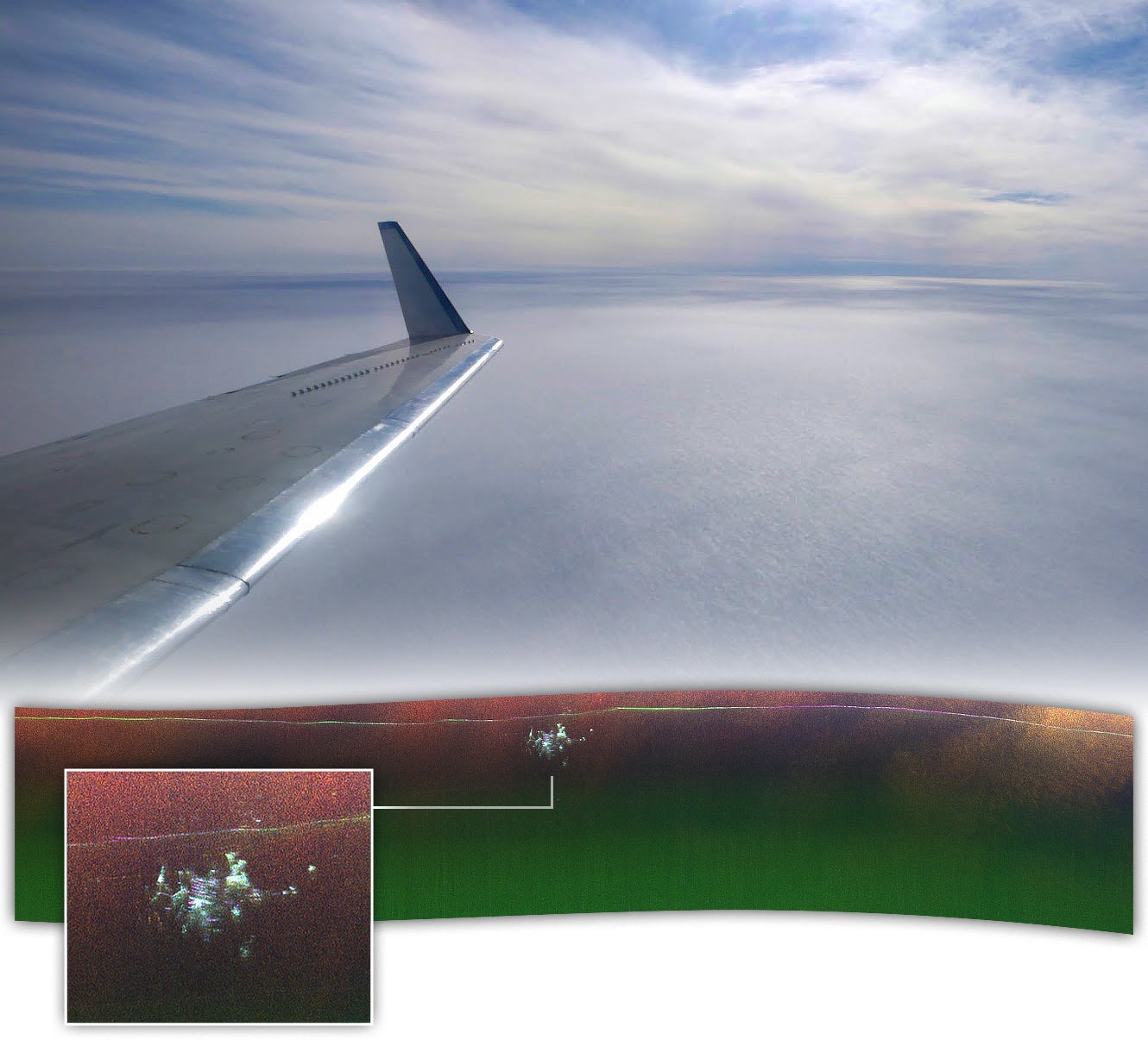
Your support makes all the difference.A radar image taken by Nasa scientists while flying over Greenland has revealed an abandoned Cold War-era “city” under the ice.
Scientists and engineers took the radar image in April 2024 as they flew over northern Greenland aboard Nasa’s Gulfstream III jet.
The abandoned city is a military base called Camp Century, built in 1959 by cutting a web of tunnels under a near-surface layer of the Greenland ice sheet.
Abandoned in 1967, snow and ice have accumulated over the camp with the facility’s solid structures now lying at least 30m (100ft) below the surface, researchers say.
“We were looking for the bed of the ice and out pops Camp Century. We didn’t know what it was at first,” Alex Gardner from Nasa’s Jet Propulsion Laboratory (JPL) said.

Past airborne surveys of the landmass produced a two-dimensional profile of the ice sheet, in contrast to the April flyby when researchers used Nasa’s UAVSAR instrument mounted to the belly of the aircraft, capable of producing “maps with more dimensionality”.
“In the new data, individual structures in the secret city are visible in a way that they’ve never been seen before,” Nasa scientist Chad Greene said.
The latest map revealed the base’s planned layout, including parallel structures that appear to align with the tunnels built to house several facilities.
Maps made using conventional radar were used to corroborate Camp Century’s depth estimates.
This calculation helps determine when the melting ice could re-expose the camp and any remaining biological, chemical, and radioactive waste buried with it.
Researchers hope this approach using such instruments can help scientists measure the thickness of ice sheets in similar environments in Antarctica and constrain estimates of future sea level rise.
“Our goal was to calibrate, validate, and understand the capabilities and limitations of UAVSAR for mapping the ice sheet’s internal layers and the ice-bed interface,” Dr Greene said.
“Without detailed knowledge of ice thickness, it is impossible to know how the ice sheets will respond to rapidly warming oceans and atmosphere, greatly limiting our ability to project rates of sea level rise,” he said.
Scientists hope the latest test survey results will enable the next generation of aerial mapping in Greenland, Antarctica, and beyond.
Join our commenting forum
Join thought-provoking conversations, follow other Independent readers and see their replies
Comments