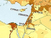
Israel not included in HarperCollins map used by children in Middle East
The maps are provided to children in English-speaking schools

Your support helps us to tell the story
From reproductive rights to climate change to Big Tech, The Independent is on the ground when the story is developing. Whether it's investigating the financials of Elon Musk's pro-Trump PAC or producing our latest documentary, 'The A Word', which shines a light on the American women fighting for reproductive rights, we know how important it is to parse out the facts from the messaging.
At such a critical moment in US history, we need reporters on the ground. Your donation allows us to keep sending journalists to speak to both sides of the story.
The Independent is trusted by Americans across the entire political spectrum. And unlike many other quality news outlets, we choose not to lock Americans out of our reporting and analysis with paywalls. We believe quality journalism should be available to everyone, paid for by those who can afford it.
Your support makes all the difference.The publisher HarperCollins has been accused of publishing a book used by schools in the Middle East that contains a map in which Israel has been omitted.
The atlas, which is distributed in English-speaking schools in the United Arab Emirates and surrounding countries, shows the West Bank clearly marked next to Gaza but with Israel not labelled, The Tablet has reported.
Bishop Declan Lang, chairman of the Bishops’ Conference Department of International Affairs, told the Catholic newspaper: “The publication of this atlas will confirm Israel’s belief that there exists a hostility towards their country from parts of the Arab world. It will not help to build up a spirit of trust leading to peaceful co-existence.”
However, Collins Bartholomew, a subsidiary of HarperCollins, said that supplying maps including Israel would be “unacceptable” to customers in the Gulf countries and that the map was a response to “local preferences”.
Palestine and Israel have been locked in a dispute over territory for more than 66 years and the most recent war ended in August after 50 days and with at least 2,100 deaths of Palestinian people and 72 Israelis, of which most were soldiers.
From 1947, United Nations partition plans sparked the delineation of boundaries and the land held by Palestinians shrunk down to areas inhabited today including the Gaza Strip, one of the most densely-populated places in the world, and parts of the West Bank. Israel has controlled the borders of these Palestinian-majority areas since the Six-Day War in 1967.
The Conservative Friends of Israel lobby, whose website states they work with 2,000 activists alongside 80 per cent of Tory MPs refers to “incitement and hate education” saying “incitement takes many forms; denial of Israel’s right to exist, depiction of all of modern Israel as part of Palestine, portrayal of children as legitimate combatants, glorification of past Palestinian suicide bombings.”
The Independent has been unable to contact HarperCollins for comment.
Join our commenting forum
Join thought-provoking conversations, follow other Independent readers and see their replies
Comments