Air Force debris tricked Utah residents into thinking radar showed giant grasshopper swarm
National Weather Service says chaff from Air Force base in Nevada caused mystery cloud
Your support helps us to tell the story
From reproductive rights to climate change to Big Tech, The Independent is on the ground when the story is developing. Whether it's investigating the financials of Elon Musk's pro-Trump PAC or producing our latest documentary, 'The A Word', which shines a light on the American women fighting for reproductive rights, we know how important it is to parse out the facts from the messaging.
At such a critical moment in US history, we need reporters on the ground. Your donation allows us to keep sending journalists to speak to both sides of the story.
The Independent is trusted by Americans across the entire political spectrum. And unlike many other quality news outlets, we choose not to lock Americans out of our reporting and analysis with paywalls. We believe quality journalism should be available to everyone, paid for by those who can afford it.
Your support makes all the difference.Last month, Utah residents feared a giant swarm of grasshoppers was heading towards the northwest part of the state, after weather radars picked up a massive blue blob heading towards the city of Tooele.
The anamoly was not a horde of critters, but detritus from a nearby military base, according to the National Weather Service.
“There are news stories going around about a swarm of grasshoppers potentially appearing on our northern UT weather radar,” the NWS said in a tweet on Saturday. “After further investigation, we’ve determined that the most likely cause of the signature on 6/21 was chaff originating from Nellis Air Force Base in Nevada.”
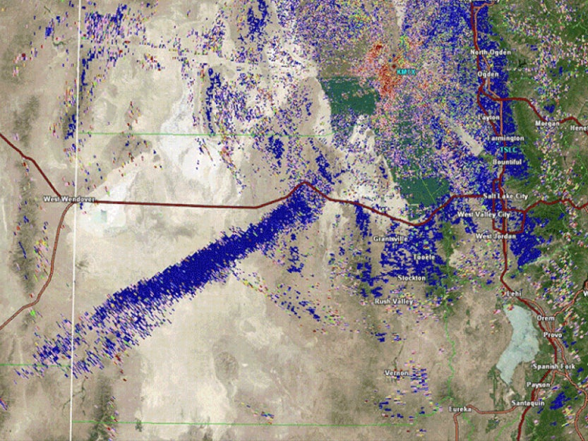
Chaff is a reflective substance dropped by military aircraft that scrambles radar systems.
Meteorologists initially thought the cloud might be insects because it appeared non-uniform, versus the more contiguous shapes of major weather patterns.


“It can sometimes confuse our radars as well,” Utah meteorologist Monica Traphagan told the Salt Lake Tribune. “The appearance of insects and chaff can have some similar characteristics, which led to the error in the original analysis.”
Utah residents could be forgiven for thinking a biblical bug cloud was heading their way.
In nearby Nevada, blood-red Mormon crickets have been swarming in the north of the state in a mass hatching that began in May.
“It’s almost like a biblical plague,” Elko resident Dana Dolan told The Associated Press
In 2021, large swarms of grasshoppers hit across Utah during a drough, damaging agricultural yields.
The state only recently exited the extreme drought stage it has been in since June of 2020.
A massive snowpack in the winter of 2022 helped get the state back on track.
“Just looking at the entire state at once, we’re currently about 195% of normal,” Utah Snow Survey Supervisor Jordan Clayton told 2News in March. “That number is starting to become less meaningful because what’s probably more interesting to viewers and to listeners is that we’re well outside of the 1983 record at this point,” Clayton said. He went on to call Utah’s ‘22-’23 winter snowpack “the greatest since 1952.”
Join our commenting forum
Join thought-provoking conversations, follow other Independent readers and see their replies
Comments