Trump forced to deny personally doctoring hurricane map after sharpie spotted on his desk
'I don't know, I don't know, I don't know,' US president says when asked about apparent use of black marker
Your support helps us to tell the story
From reproductive rights to climate change to Big Tech, The Independent is on the ground when the story is developing. Whether it's investigating the financials of Elon Musk's pro-Trump PAC or producing our latest documentary, 'The A Word', which shines a light on the American women fighting for reproductive rights, we know how important it is to parse out the facts from the messaging.
At such a critical moment in US history, we need reporters on the ground. Your donation allows us to keep sending journalists to speak to both sides of the story.
The Independent is trusted by Americans across the entire political spectrum. And unlike many other quality news outlets, we choose not to lock Americans out of our reporting and analysis with paywalls. We believe quality journalism should be available to everyone, paid for by those who can afford it.
Your support makes all the difference.Donald Trump has denied personally altering a map to support a false claim about Hurricane Dorian after a sharpie pen was spotted lying close-by on his desk.
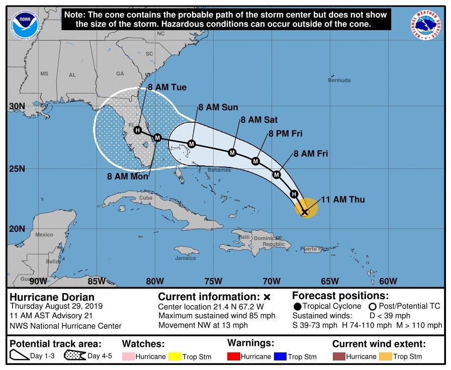
In a White House video released on Wednesday, Mr Trump points to an official weather chart dated 29 August showing the states that could be hit in what the National Hurricane Center (NHC) calls the “cone of uncertainty”.
But a curved black line had been added to the cone on the chart to show a risk that Dorian could move from Florida to Alabama. Bloomberg reported Mr Trump had added the line himself, citing people familiar with the issue.
“It was going to hit not only Florida, but Georgia, it could have, it was going towards the Gulf, that was what we, what was originally projected,” Mr Trump tells reporters in the video, while a black sharpie pen lies close by on his Oval Office desk.
But multiple forecasters, including the government’s National Weather Service, have repeatedly said Alabama would not see any impact from Dorian.
“We repeat, no impacts from Hurricane #Dorian will be felt across Alabama. The system will remain too far east,” the NWS tweeted on 1 September.
Asked later how the map, which featured the logo of the National Oceanic and Atmospheric Administration (NOAA), had come to be doctored, Mr Trump said: “No ... I just know, I know Alabama was in the original forecast.
“They thought they would get it as a piece of it. It was supposed to go — actually we have a better map than that which is going to be presented where we had many lines going directly, many models, each line being a model, and they were going directly through. And in all cases Alabama was hit.”

Confronted by a reporter again about the apparent use of a sharpie on the map, Mr Trump added: “I don’t know, I don’t know, I don’t know.”
When asked for clarification, the NOAA referred The Independent to the White House press office, which has been contacted for comment.

Janice Dean, a meteorologist at Fox News, later tweeted: “Just so everyone is clear. This forecast cone was from 5 days ago. Alabama was NEVER in the official cone from the [National Hurricane Center].
“The sharpie-bubble was drawn by someone else. This map is inaccurate, misleading and fake.”
Any doctoring of an NHC map could also be illegal, as a US law on false weather reports states it is a violation to "knowingly issue or publish any counterfeit weather forecast or warning of weather conditions falsely representing such forecast or warning to have been issued or published by the Weather Bureau".
On Wednesday evening, Mr Trump appeared to provide the "better map" when he tweeted a so-called spaghetti plot by the South Florida Water Management District, dated 28 August, showing Alabama potentially being affected by the hurricane.
However, beneath the map was a note warning users the graph was superseded by NHC advisories.
“If anything on this graphic causes confusion, ignore the entire product,” it added.
The graphic was also produced a full four days before Mr Trump on Sunday insisted Alabama “most likely” would be hit by the record-breaking hurricane. By then, no forecasters were predicting any issue for the southern state, but Mr Trump at an emergency briefing claimed the information about Alabama “just came up, unfortunately”.
Early on Thursday morning, Mr Trump doubled down on his insistence he was correct.
"In the early days of the hurricane, when it was predicted that Dorian would go through Miami or West Palm Beach, even before it reached the Bahamas, certain models strongly suggested that Alabama & Georgia would be hit as it made its way through Florida & to the Gulf," he tweeted.
"Instead it turned North and went up the coast, where it continues now. In the one model through Florida, the Great State of Alabama would have been hit or grazed. In the path it took, no. Read my FULL FEMA statement. What I said was accurate! All Fake News in order to demean!"

Join our commenting forum
Join thought-provoking conversations, follow other Independent readers and see their replies
Comments