Tropical Storm Francine forecast to be Category 2 hurricane when it slams into Gulf Coast
Storm is projected to bring up nearly a foot of rain in parts of Louisiana, Mississippi, southern Alabama and western Florida
Your support helps us to tell the story
From reproductive rights to climate change to Big Tech, The Independent is on the ground when the story is developing. Whether it's investigating the financials of Elon Musk's pro-Trump PAC or producing our latest documentary, 'The A Word', which shines a light on the American women fighting for reproductive rights, we know how important it is to parse out the facts from the messaging.
At such a critical moment in US history, we need reporters on the ground. Your donation allows us to keep sending journalists to speak to both sides of the story.
The Independent is trusted by Americans across the entire political spectrum. And unlike many other quality news outlets, we choose not to lock Americans out of our reporting and analysis with paywalls. We believe quality journalism should be available to everyone, paid for by those who can afford it.
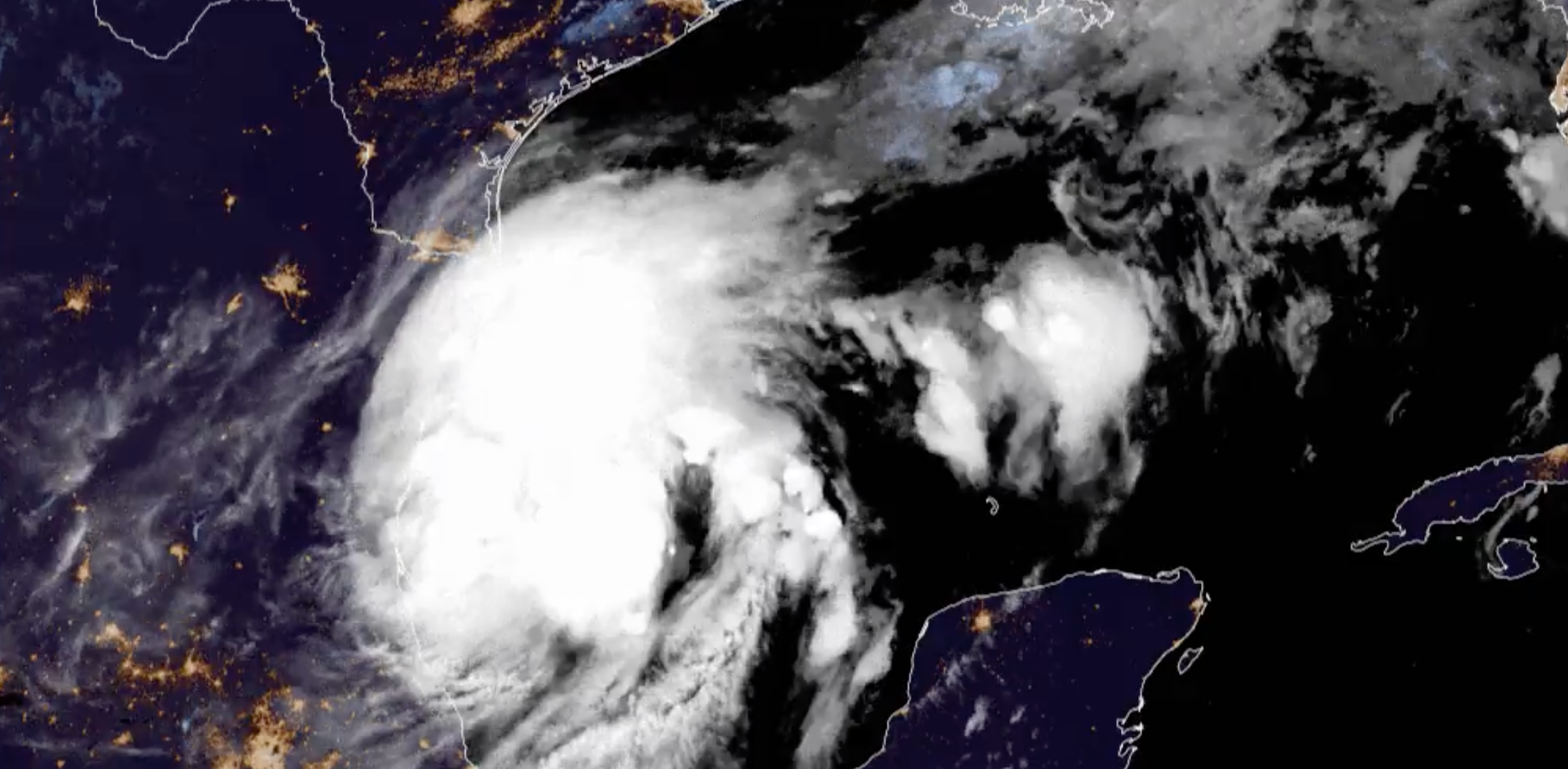
Your support makes all the difference.Tropical Storm Francine is gaining strength offshore and is expected to make landfall as a hurricane along the Gulf Coast Wednesday.
Communities in Texas and Louisiana are bracing for the brunt of the impact with strong winds and up to a foot of rain in the region. The government of Louisiana’s Iberia Parish, near Lafayette, urged residents to consider voluntary evacuation on Monday night. The governor of Mississippi declared a state of emergency on Tuesday.
Francine has maximum sustained winds of 65 miles per hour and is projected to track northward before turning to the northeast and picking up speed. Tropical-storm-force winds extend outward from the storm’s center by 140 miles.
A hurricane warning is in effect from the Louisiana coastline east of Cameron to Grand Isle. A tropical storm warning was issued for the Texas and Louisiana coasts east of High Island to Cameron, east of Grand Isle, Louisiana to the Alabama and Florida border, Lake Maurepas and Lake Pontchartrain and metropolitan New Orleans.
Workers with the Southeast Louisiana Flood Protection Authority closed floodgates along the city’s Harvey Canal Tuesday morning.
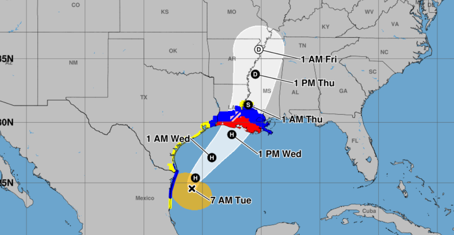
Areas from Sabine Pass, Texas to the Mississippi/Alabama border were under a storm surge warning. A storm surge watch was also issued from the Mississippi/Alabama border to the Alabama/Florida border.
Hurricane conditions are likely to begin on Wednesday.
Francine is expected to dump four to eight inches of rainfall – although parts of Louisiana and Mississippi could see local amounts of 12 inches through Friday morning. The National Hurricane Center warned that heavy rain could lead to flash and urban flooding.
Storm surge and tide will also bring the threat of flooding to normally dry areas near the coast, with waters as high as 5-10 feet possible from Louisiana’s Cameron to Port Fourchon and Vermilion Bay. The area from Port Fourchon to the mouth of the Mississippi River could see floodwaters as high as seven feet.
The deepest water will occur along the immediate coast and to the east of where the storm makes landfall, with surge accompanied by “large and dangerous waves. “ Swells were likely to cause life-threatening surf and rip current conditions. While there may be some overtopping of local levees, surge is not expected to threaten risk reduction system levees.
The agency also warned that some tornadoes were possible from Wednesday morning through the evening over near-coastal areas of Louisiana, Mississippi, Alabama, and the Florida Panhandle.
While the hurricane will bring dangerous conditions, it will also provide some relief from the extreme heat that’s swept over much of the southern U.S. in the last week, causing stress on crops. That heat will continue to bake other parts of the West and Southwest on Monday and Tuesday.
These predictions come following an eerily quiet period in the Atlantic this summer. The fifth named storm was Ernesto, which strengthened into a hurricane in mid-August. Although September is known as peak hurricane season, not a single named storm has formed since last month.
The season is still projected to be above average, with a forecast from the National Hurricane Center predicting as many as 24 named storms at the beginning of last month.
And, it got off to an explosive start. Hurricane Beryl, the first major storm of the season, formed in late June. In July, it became the earliest Category 5 hurricane observed in the Atlantic and the strong July Atlantic hurricane ever recorded.
As the global climate warms, NASA scientists predict that hurricanes will cause more intense impacts. Those threats include increased rainfall totals and higher storm surge.
The Independent will be revealing its Climate100 List in September and hosting an event in New York, which can be attended online.
Join our commenting forum
Join thought-provoking conversations, follow other Independent readers and see their replies
Comments