Disturbing before-and-after images show what major US cities could look like in the year 2100
Worst climate change predictions forecast cities from New York to New Orleans will be devastated due to flooding by turn of century
Your support helps us to tell the story
From reproductive rights to climate change to Big Tech, The Independent is on the ground when the story is developing. Whether it's investigating the financials of Elon Musk's pro-Trump PAC or producing our latest documentary, 'The A Word', which shines a light on the American women fighting for reproductive rights, we know how important it is to parse out the facts from the messaging.
At such a critical moment in US history, we need reporters on the ground. Your donation allows us to keep sending journalists to speak to both sides of the story.
The Independent is trusted by Americans across the entire political spectrum. And unlike many other quality news outlets, we choose not to lock Americans out of our reporting and analysis with paywalls. We believe quality journalism should be available to everyone, paid for by those who can afford it.
Your support makes all the difference.The world’s sea levels are rising at faster and faster rates as waters warm and ice sheets melt.
Researchers led by Steve Nerem, a professor of aerospace engineering at the University of Colorado Boulder, looked at satellite data dating back to 1993 to track sea-level rise.
Their findings, published in the journal Proceedings of the National Academy of Sciences, show that sea levels aren’t just rising, but that the rate has been accelerating over the past 25 years.
Even small increases can have huge consequences, experts on climate say. If the worst climate-change predictions come true, coastal US cities from New York to New Orleans will be devastated by flooding and greater exposure to storm surges by 2100.
The research group Climate Central has created a plug-in for Google Earth to illustrate how catastrophic an “extreme” sea-level-rise scenario would be if the flooding happened today, based on projections in a 2017 report from the National Oceanic and Atmospheric Administration.
You can install the plug-in and see what might become of major US cities.
In a worst-case scenario, flooding caused by polar melting and ice-sheet collapses could cause a sea-level rise of 10 to 12 feet by 2100, NOAA reported in January 2017.
Here’s Washington, DC, today, with the Potomac River running through it.
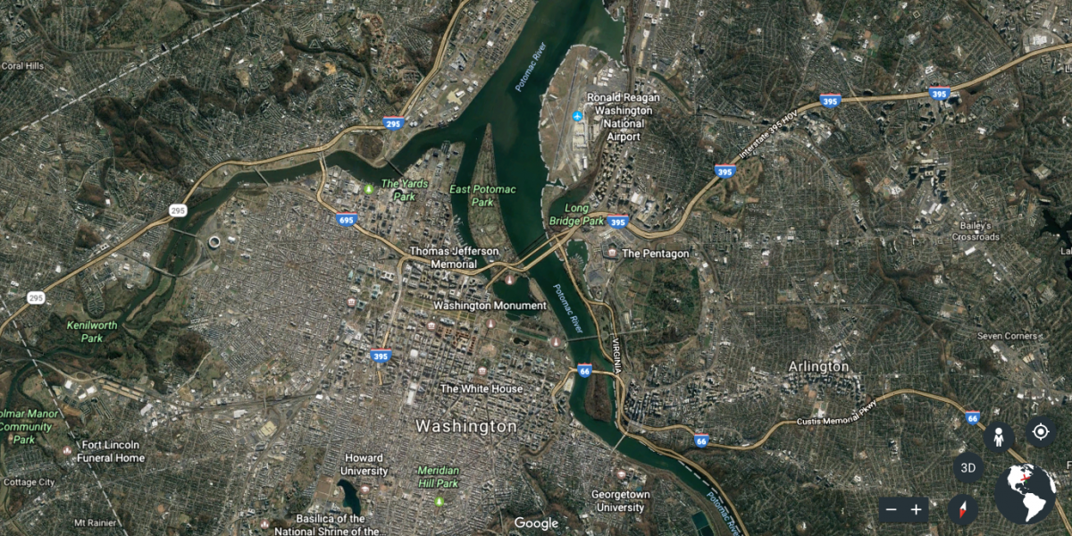
And here’s what Washington, DC, might look like in 2100, as seen on Climate Central’s plug-in for Google Earth. Rising sea levels could cause the river to overflow.
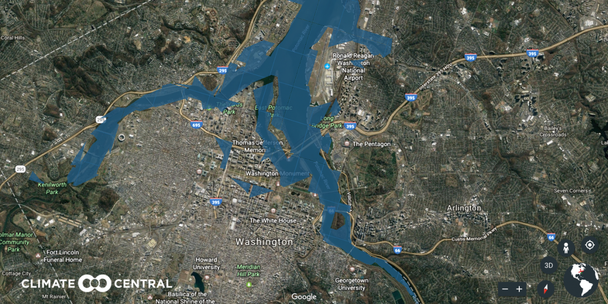
Despite claims by the former White House press secretary Sean Spicer, president Donald Trump drew modest crowds at his inauguration in January 2017 along the National Mall, which sits at the foot of the US Capitol.
Future inaugurations wouldn’t be quite the same.
Last year, Mr Trump stood outside the White House and announced his intentions to withdraw the US from the Paris climate agreement, a deal among 195 countries designed to mitigate climate change.
In 2100, the White House’s Rose Garden could have an oceanfront view.
New York City is situated on one of the world’s largest natural harbours.
The Hudson River could flood the city’s perimeter and low-lying areas like the West Village by 2100.
The Financial District encompasses the offices of many major financial institutions, including the New York Stock Exchange and the Federal Reserve Bank of New York.
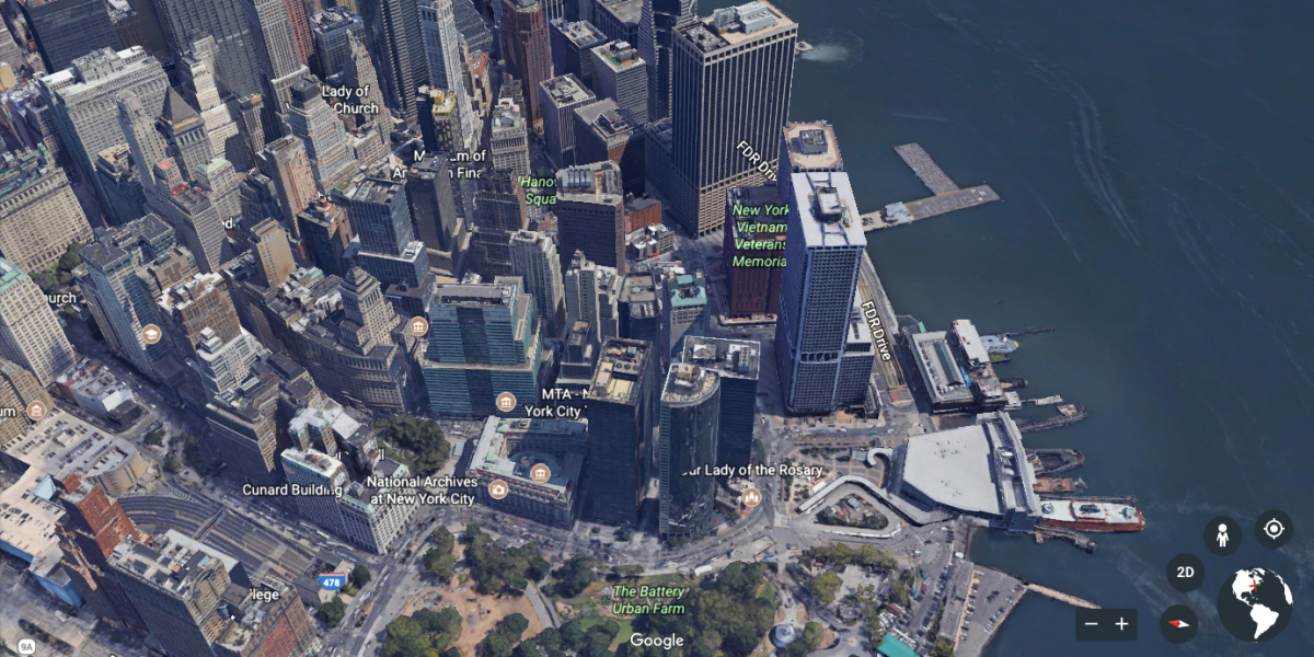
Extreme sea-level rise could devastate Wall Street. Battery Park would be a water park.
San Francisco is home to a huge concentration of wealth and power in the technology world.
It’s also a peninsula prone to flooding.
This swath of downtown San Francisco includes offices for LinkedIn, Business Insider and Salesforce.
They would be too close to the waterfront to avoid flooding.
Farther south in Silicon Valley, Facebook’s campus dazzles in Menlo Park.
As if the social media giant didn’t have enough problems on its hands already, its headquarters could someday be underwater.
Apple’s new campus (the big ring) in Cupertino, California, would stay high and dry.
San Francisco International Airport serves more than 50 million travellers every year.
In 2100, people might have better luck flying into Las Vegas.
Charleston, South Carolina, already has a flooding problem. It’s flat and has a low elevation, making it vulnerable to extreme flooding and storm surges.

In 2100, you might need a boat to reach the city’s centre.
Shopping at the Charleston City Market is a must for tourists visiting the area.
But the long row of red-roofed buildings could be submerged by 2100.
Los Angeles, which has the third-highest elevation among major US cities, might fare better.
The projections show the Pacific Ocean climbing up the boardwalk, but that’s about it.
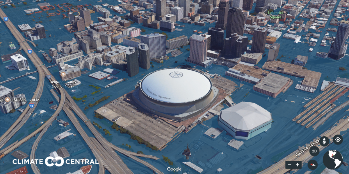
New Orleans is no stranger to the problems that come with sea-level rise.
By 2100, the Big Easy could disappear underwater. An estimated 500,000 people could have to leave the area in the next century to stay aboveground.
After flooding caused by Hurricane Katrina destroyed numerous homes in the New Orleans area in 2005, tens of thousands of people sought refuge at the Mercedes-Benz Superdome.
But the arena might not survive extreme sea-level rise.
Boston is the only state capital in the continental US that borders an ocean. Extreme sea-level rise could cause the Charles River to overflow and spill onto city streets.
Here’s what Boston could look like in 2100. Massachusetts General Hospital might have to be abandoned, while the Public Garden would be soaked.
Many of the country’s top universities sit along Boston’s Charles River.
The education world could say goodbye to Harvard Business School, Boston University, the Massachusetts Institute of Technology and Northeastern University, among others.
Mr Trump has spent a decent part of his presidency in Palm Beach, Florida.
He owns the Mar-a-Lago luxury resort and club, better known as the Winter White House.
If sea levels rose by as much as 12 feet, Mar-a-Lago would not fare well.
But Mr Trump will be out of office by the time anything like that could happen.
Read more:
• Barnier: Britain has to follow EU regulations forever if it wants a Brexit trade deal
• Trump is weighing a massive strike on Syria – and it could bring all-out war with Russia
• Mark Zuckerberg gave his grueling testimony to Congress from a 4-inch booster seat
Read the original article on Business Insider UK. © 2018. Follow Business Insider UK on Twitter.
Join our commenting forum
Join thought-provoking conversations, follow other Independent readers and see their replies
Comments