La Niña winter is nearly here. How could the climate pattern affect the US?
Last year’s El Niño event brought the warmest winter on record in the continental US
Your support helps us to tell the story
From reproductive rights to climate change to Big Tech, The Independent is on the ground when the story is developing. Whether it's investigating the financials of Elon Musk's pro-Trump PAC or producing our latest documentary, 'The A Word', which shines a light on the American women fighting for reproductive rights, we know how important it is to parse out the facts from the messaging.
At such a critical moment in US history, we need reporters on the ground. Your donation allows us to keep sending journalists to speak to both sides of the story.
The Independent is trusted by Americans across the entire political spectrum. And unlike many other quality news outlets, we choose not to lock Americans out of our reporting and analysis with paywalls. We believe quality journalism should be available to everyone, paid for by those who can afford it.
Your support makes all the difference.While states across the Midwest and Northeast see their first freeze warnings of the season, forecasters said this week that a La Niña event is expected to develop later this year.
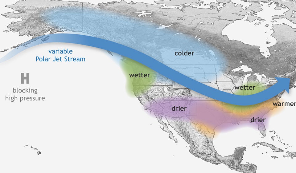
As the cool phase of the El Niño Southern Oscillation (ENSO) — a natural climate pattern of alternating warmer and cooler surface waters in the tropical Pacific — La Niña would have the opposite effect of the El Niño pattern the US saw last winter.
While the northern US is dryer and warmer than usual and the southern US is wetter during El Niño events, La Niña would bring cooler temperatures to the north and warmer weather down south. The events occur every two to seven years, on average, but El Niño generally occurs more often than La Niña.
Both tend to have stronger impacts on the US during the winter than in the summer. Last year’s El Niño led to the warmest winter on record for the continental US.

Although the switch is expected, NOAA forecast that it will be a weak La Niña event. The agency gives the pattern a 60 percent chance of developing from now through November. Historically, as of 1950, only four such events have formed this late in the year.
NOAA wrote that good indicators of a change in patterns include cooler or warmer water measured under the ocean’s surface, and a strong, long-lasting shift in the trade winds. Normally, trade winds blow west along the equator in the Pacific Ocean, moving warm water towards Asia. El Niño and La Niña break these normal conditions, and a La Niña event is marked by even stronger trade winds than are normal.

With La Niña, as trade winds push more warm water west, cold, deeper waters surface near the Americas in a process called upwelling. The emergence of cooler water pushes the Pacific jet stream, a large stream of air, north across the US.
Right now, conditions across the world are neutral, with temperatures in the central Pacific Ocean holding steady during the past few months.
Models last winter had predicted that La Niña would develop rapidly after the end of El Niño, but weaker equatorial trade winds in September could not have been predicted more than a couple of weeks in advance.
“These small fluctuations can tip the scales one way or the other. In this case, they’ve added up to a slower and weaker La Niña development. That said, many of our models are holding steady for La Niña to develop shortly,” NOAA said.
La Niña is expected to persist from January to March of next year.
Join our commenting forum
Join thought-provoking conversations, follow other Independent readers and see their replies
Comments