UK weather mapped: Met Office issues four days of warnings with 70mph gales and heavy rain
Strong and gusty winds are likely to cause some travel disruption, with some journeys taking longer than usual and potential delays to road, rail, air and ferry services.
Your support helps us to tell the story
From reproductive rights to climate change to Big Tech, The Independent is on the ground when the story is developing. Whether it's investigating the financials of Elon Musk's pro-Trump PAC or producing our latest documentary, 'The A Word', which shines a light on the American women fighting for reproductive rights, we know how important it is to parse out the facts from the messaging.
At such a critical moment in US history, we need reporters on the ground. Your donation allows us to keep sending journalists to speak to both sides of the story.
The Independent is trusted by Americans across the entire political spectrum. And unlike many other quality news outlets, we choose not to lock Americans out of our reporting and analysis with paywalls. We believe quality journalism should be available to everyone, paid for by those who can afford it.
Your support makes all the difference.Britain is set to be lashed by 70mph winds and heavy rain again, with the Met Office issuing four days of weather warnings.
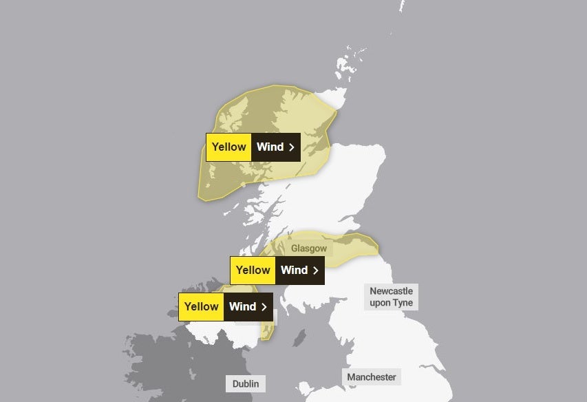
The latest spate of bad weather began on Sunday morning, with three yellow warnings in place for parts of Scotland and Northern Ireland.
In place until 8pm, strong and gusty winds are likely to cause some travel disruption, with some journeys taking longer than usual and potential delays to road, rail, air and ferry services.

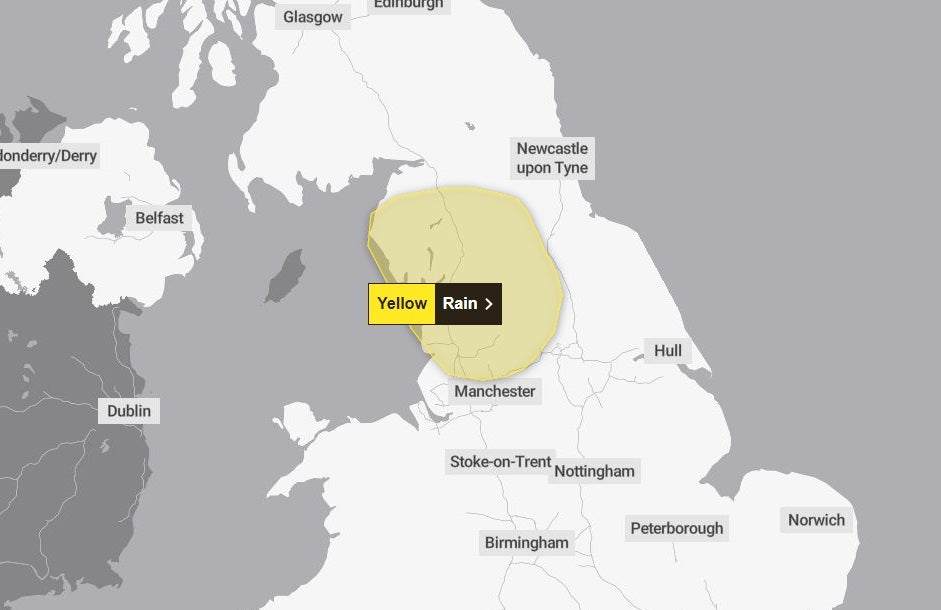
A separate yellow warning for rain has been issued for parts of North West England on Monday, where nearly 2 inches of rain could fall in the worst affected areas.
Between noon on Monday and 5am on Tuesday, rain will be heavy and prolonged at time with 20-30mm falling widely, the forecaster said. Areas affected include Preston, Bradford, Blackpool and Lancaster. Flooding of a few homes is possible in a few areas while the rain may also cause some travel disruption.

Wednesday will see yet another yellow warning, this time for strong winds across the northernmost parts of Scotland beween 7am and 7pm.
The warnings mean January will come to a wet and windy end, with the UK having been hit by two storms already this month - Isha and Jocelyn.
However, despite the wind and rain, Sunday has seen much higher temperatures across much of the country with the mercury finally reaching double digits after weeks of sub-zero temperatures.
A new provisional UK record for the highest maximum temperature on a January day has been recorded in northern Scotland, the Met Office said. Kinlochewe recorded 19.6C on Sunday, the agency said.
Southern areas of the UK were forecast to have milder temperatures and bright skies on Sunday as a weather system coming from the south brings warmer air.
“Over towards parts of Northern Ireland, western Scotland, we will start to see this band of rain move in,” Craig Snell, Met Office meteorologist, said of Sunday’s forecast.
“Some heavy rain accompanied by some very strong winds, which could actually widely reach around 60-70mph across parts of the Western Isles before transferring over towards Orkney and Shetland as we go into Sunday evening.”
Mr Snell added that the rain on Monday could be quite heavy” at times as he warned drivers to watch out for “surface spray on the roads”.
Looking ahead to Tuesday, it will be dry tough turning wet and windy again from Wednesday with severe gales in the northwest, the Met said.
The weather will stay unsettled on Thursday, though not as windy and it will feel very mild through the week.
MET OFFICE OUTLOOK
Sunday:
A blustery day, particularly in the far northwest of Scotland with severe gales. Cloudy in the west, with some drizzle to start, otherwise dry with hazy sunshine. Rain, sometimes heavy, arriving into the far northwest through the afternoon. Feeling mild.
Sunday evening:
Rain reaching northwest Wales and northern England by dawn. Clearer across Scotland and Northern Ireland, though cloud and hill fog in the south. Easing winds. Turning chilly under clear skies.
Monday:
Rain, sometimes heavy, will stretch from northeast England to southwest Wales. Drier elsewhere with fog in the southeast to start. Breezy around western coasts. Largely mild though chilly in Scotland.
Outlook for Tuesday to Thursday:
Dry on Tuesday though turning wet and windy from Wednesday with severe gales in the northwest. Staying unsettled on Thursday, though not as windy. Feeling very mild through the week.

Join our commenting forum
Join thought-provoking conversations, follow other Independent readers and see their replies
Comments