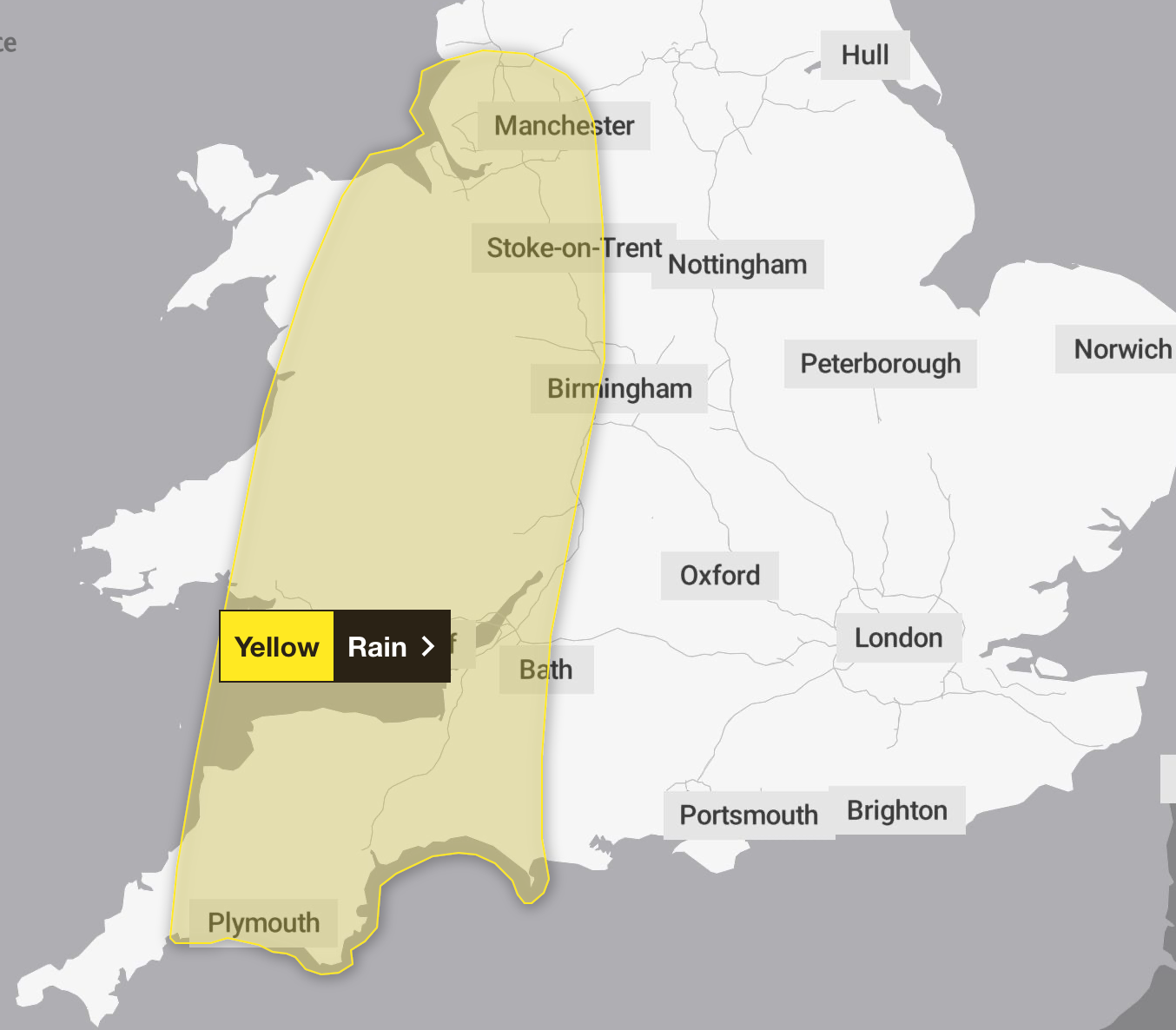
Met Office issues yellow weather warnings for rain as temperatures to rise to 22C
Parts of the UK are preparing for heavy rain this week causing travel disruption and flooding

Your support helps us to tell the story
From reproductive rights to climate change to Big Tech, The Independent is on the ground when the story is developing. Whether it's investigating the financials of Elon Musk's pro-Trump PAC or producing our latest documentary, 'The A Word', which shines a light on the American women fighting for reproductive rights, we know how important it is to parse out the facts from the messaging.
At such a critical moment in US history, we need reporters on the ground. Your donation allows us to keep sending journalists to speak to both sides of the story.
The Independent is trusted by Americans across the entire political spectrum. And unlike many other quality news outlets, we choose not to lock Americans out of our reporting and analysis with paywalls. We believe quality journalism should be available to everyone, paid for by those who can afford it.
Your support makes all the difference.The Met Office has issued yellow weather warnings for rain which are likely to affect much of the UK over the next two days.
The unsettled forecast comes after experts predicted midweek temperatures could exceed 20C in many regions.
After a stretch of wet, cold, and blustery weather that has characterised the beginning of October, the warm spell was expected to bring a brief respite. But several areas including North West England, South West England, the West Midlands and Wales may see the increased temperatures disrupted by more rainfall.
The first yellow warning for rain will be in effect from 6pm until midday tomorrow. During this period, heavy downpours are expected, with many areas likely to see 10 to 20mm of rain.

A second weather warning for rain will come into effect tomorrow in Northern Ireland from midnight to 6am across parts of Co Armagh and Co Down.
Isolated thunderstorms could also take place, adding the risk of lightning and travel disruption. A Met Office spokesperson said: “Areas of heavy rain are expected to develop and push north across the warning area.
“Rain will develop in South West England in the late afternoon, before becoming heavier and expanding north on Tuesday evening and overnight into Wednesday.”
Residents in these areas are advised to prepare for heavy downpours that could lead to significant disruption.
Places such as Blackburn, Cheshire and Lancashire are at heightened risk. These areas are expected to experience periods of intense rainfall, which could result in localised flooding and hazardous driving conditions.
Heading south, the situation remains similar in cities like Bath, Dorset and Plymouth. In Wales, the warning covers areas including Gwynedd and Cardiff, where the potential of flooding is also significant.
Residents could experience power cuts for homes and businesses, and some communities may even find themselves temporarily cut off due to flooding.
Commuters are advised to remain cautious as delays and cancellations to train and bus services are likely. Difficult driving conditions are also expected, with drivers facing road closures.
The Met Office warned: “Check if your property could be at risk of flooding. If so, consider preparing a flood plan and an emergency flood kit.
“Give yourself the best chance of avoiding delays by checking road conditions if driving, or bus and train timetables, amending your travel plans if necessary.
“People cope better with power cuts when they have prepared for them in advance.”
As the week progresses, the weather outlook is set to shift dramatically. While the yellow warning will remain in place until midday tomorrow, the intensity of the rain is expected to ease by Thursday.
However, from Saturday through to Monday, particularly unsettled weather is anticipated in the North and West, with a deep low-pressure system likely to develop.
This could bring further heavy rain and strong winds, particularly affecting the northern regions.
Join our commenting forum
Join thought-provoking conversations, follow other Independent readers and see their replies
Comments