UK weather: Snow in your area as temperatures set to plummet from 20C to -4C
While the weather is not unusual for this time of year, it’s far from the warmer temperatures experienced last week
Your support helps us to tell the story
From reproductive rights to climate change to Big Tech, The Independent is on the ground when the story is developing. Whether it's investigating the financials of Elon Musk's pro-Trump PAC or producing our latest documentary, 'The A Word', which shines a light on the American women fighting for reproductive rights, we know how important it is to parse out the facts from the messaging.
At such a critical moment in US history, we need reporters on the ground. Your donation allows us to keep sending journalists to speak to both sides of the story.
The Independent is trusted by Americans across the entire political spectrum. And unlike many other quality news outlets, we choose not to lock Americans out of our reporting and analysis with paywalls. We believe quality journalism should be available to everyone, paid for by those who can afford it.
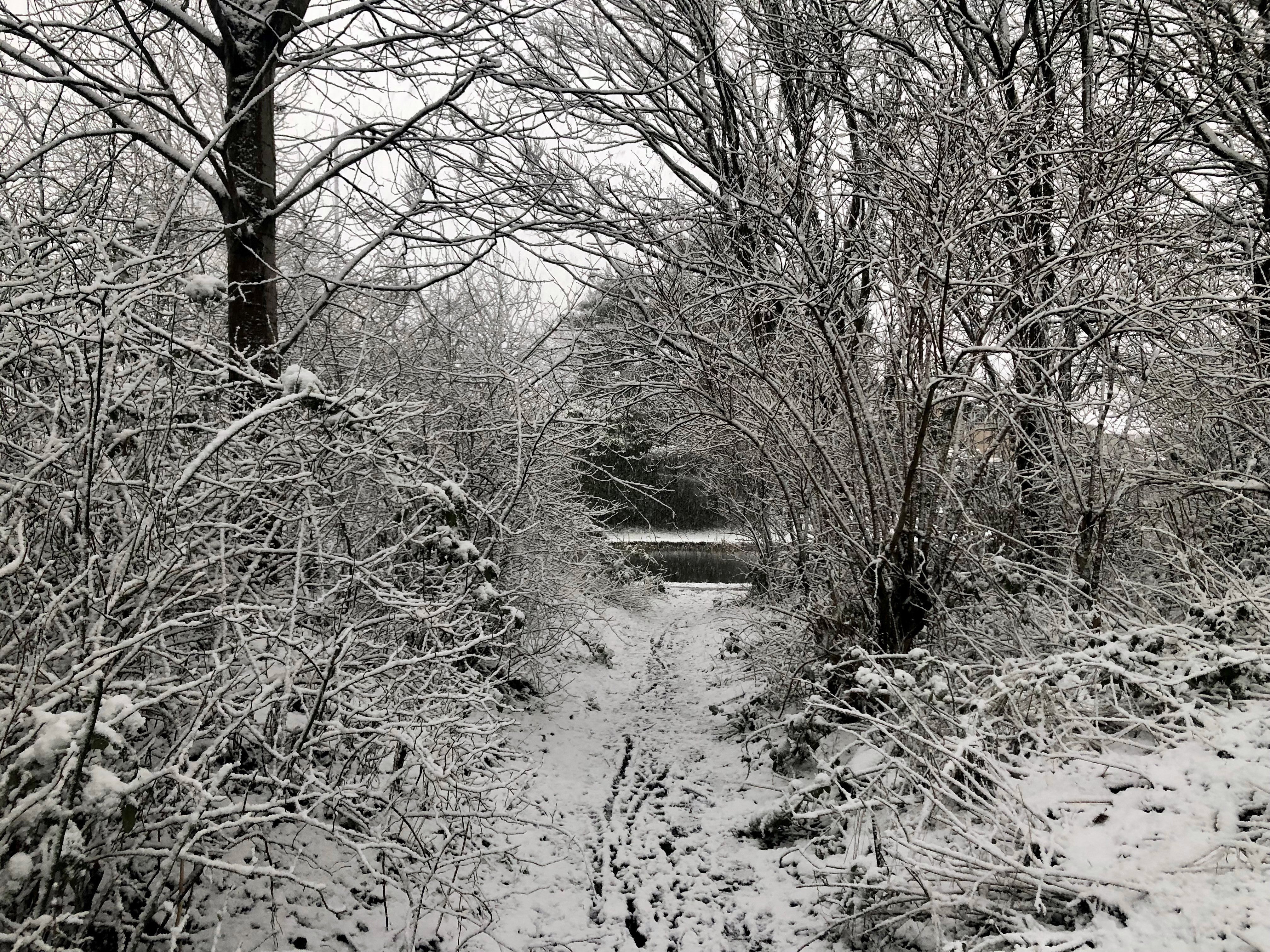
Your support makes all the difference.The UK could see snowfall this week, with temperatures set to drop dramatically over the coming days, forecasters have said.
After enjoying warmer weather and experiencing the hottest day of the year so far in March, the country will become colder and cloudier from Monday.
The daytime will see temperatures halve from the highs of 20C reached last week, and they are expected to drop below freezing overnight, the Met Office said.
A cold air mass is expected to arrive on Monday evening and will push into the north of the UK before slowly sinking southwards, bringing cooler, more unsettled weather.
Snow is expected to fall in Scotland and the north of England from Wednesday, areas that will see the most of the wintry weather, with temperatures of 8C expected.
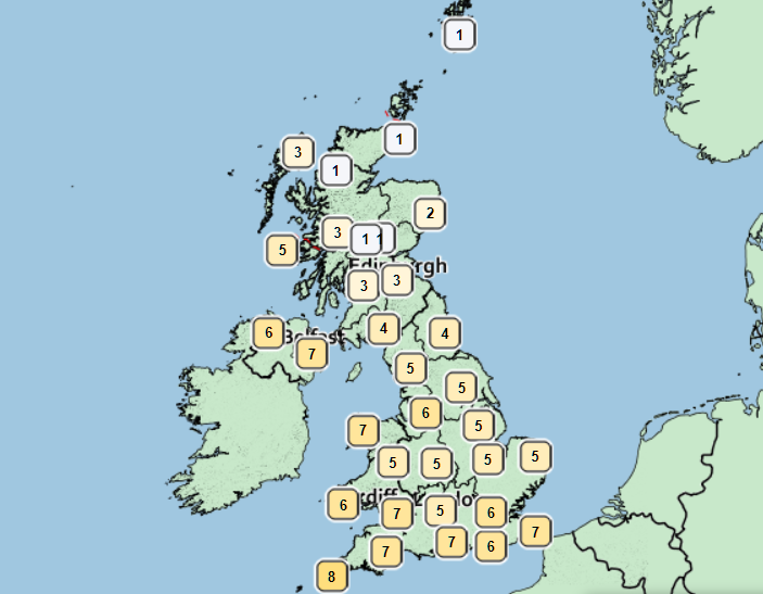
The frosty conditions will hit parts of central England and northern Wales – regions that are expected to be the worst affected – overnight into Thursday and Friday.
Temperatures will fall considerably lower than freezing, towards -4C, with up to four inches of snow expected to settle across these areas.
Showers will also be possible for much of the country on Friday before high pressure from the west brings wintry winds, more frequently in the north and east.
The Met Office’s chief meteorologist, Paul Gundersen, said: “Although the UK has had a good deal of fine and settled March weather in recent days, a change is on the way from the middle of next week, with colder air spreading down from the north and the increasing likelihood of rain for most areas. On the hills in the north, there’s a chance of this falling as snow, although we’ll gain more certainty on that in the coming days.
“With the influence of some unsettled weather, we’ll be seeing a marked drop in temperatures for most, with colder air arriving from the north. This will see maximum temperatures drop into single figures for many areas, and below freezing overnight.”
London and the southeast of England
Monday will see bright and sunny spells before the weather turns colder on Tuesday, which will be cloudier for most, with outbreaks of showers and a maximum temperature of 11C.
Wintry showers will begin to approach on Wednesday evening, and are expected fall on Thursday and Friday, with frost also building up overnight.
Southwest of England
Thick clouds are expected to spread into Devon on Monday night, which will bring showery outbreaks of rain – however, it will remain frost-free.
Tuesday will see a rather cloudy day and spells of rain, with maximum temperatures of 13C, before the weather turns colder and windy on Thursday and Friday.
Midlands
Frost will begin to build up on Monday night with low cloud, fog and outbreaks of rain – which could turn to snow over high ground – expected on Tuesday, with maximum temperatures of 11C.
Outbreaks of rain and hill snow will move south on Wednesday, and will be followed by sunny spells and wintry showers on Thursday and Friday.
Wales
There will be an early mist on Tuesday morning before sunny spells break through, and temperatures of up to 14C, with the possibility of showers in the south of the country.
Clouds and rain from the north will arrive on Wednesday and are expected to turn wintry over higher ground from Wednesday.
North of England
The North will see a clouds and mist form overnight before further showers expected to develop on Tuesday evening, though clearer spells are more likely toward the southwest with maximum temperatures of up to 14C.
Wednesday will see the arrivals of rain, potentially wintry, with high winds, before sunny spells and showers take over on Thursday and Friday.
Scotland
Scotland can expect bright spells and scattered wintry showers for the most part, with snow expected to settle overnight.
The weather mid-week will remain cold but bright, with more wintry showers and the occasional strong, northeasterly winds.
Northern Ireland
Monday evening will remain clear with light overnight winds bringing mist to Northern Ireland on Tuesday, with temperatures reaching a maximum of 15C.
Clouds and rain are expected from Wednesday, with a bright but cold end to the week and the possibility of wintry showers and frost.
Met Office Outlook
Today:
Fog and low cloud slowly clearing inland to allow some warm sunny spells in places. Some rain or showers possible across parts of northern England, southern Scotland, Northern Ireland and north Wales. Turning cloudier across southern England.
Tonight:
Low cloud and fog spreading back inland. Outbreaks of rain developing across parts of southern England and perhaps south Wales, heavy in places.
Tuesday:
Occasional rain across southern England slowly clearing. Fog and low cloud becoming confined to eastern coasts. Rain moving southwards across Scotland, followed by colder weather with wintry showers.
Outlook for Wednesday to Friday:
Band of rain and mainly hill snow will sink south Wednesday and Thursday, with cold air following. Rain and snow clearing late Thursday. Wintry showers mainly north and east Friday.
Join our commenting forum
Join thought-provoking conversations, follow other Independent readers and see their replies
Comments