UK weather: Flooding chaos as northern England warned of further misery
Residents urged to be vigilant as more than 50 warnings remain in force
Your support helps us to tell the story
From reproductive rights to climate change to Big Tech, The Independent is on the ground when the story is developing. Whether it's investigating the financials of Elon Musk's pro-Trump PAC or producing our latest documentary, 'The A Word', which shines a light on the American women fighting for reproductive rights, we know how important it is to parse out the facts from the messaging.
At such a critical moment in US history, we need reporters on the ground. Your donation allows us to keep sending journalists to speak to both sides of the story.
The Independent is trusted by Americans across the entire political spectrum. And unlike many other quality news outlets, we choose not to lock Americans out of our reporting and analysis with paywalls. We believe quality journalism should be available to everyone, paid for by those who can afford it.
Your support makes all the difference.The flooding which has brought chaos and misery to large parts of the UK is expected to last until Tuesday, according to the Environment Agency (EA).
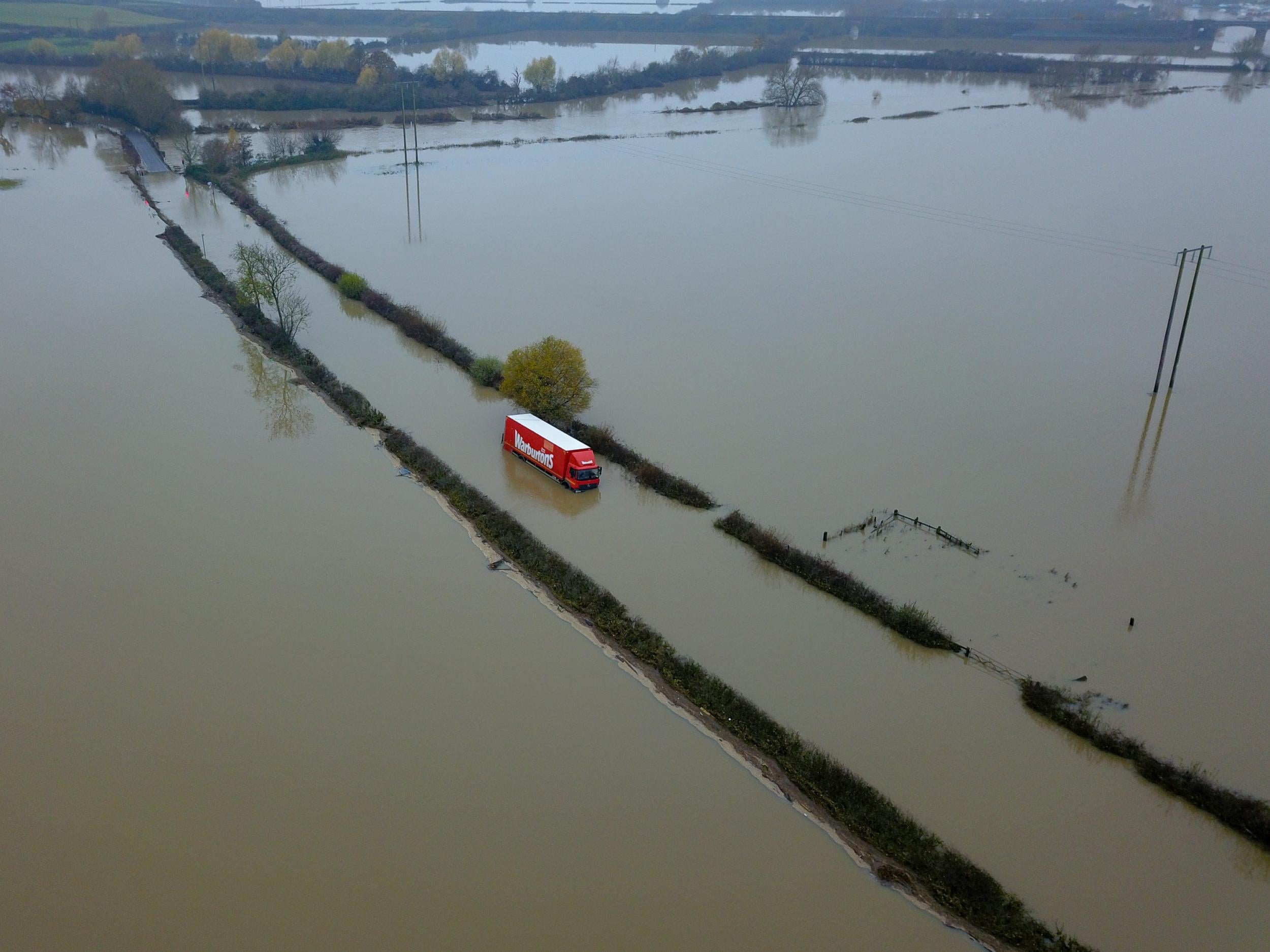
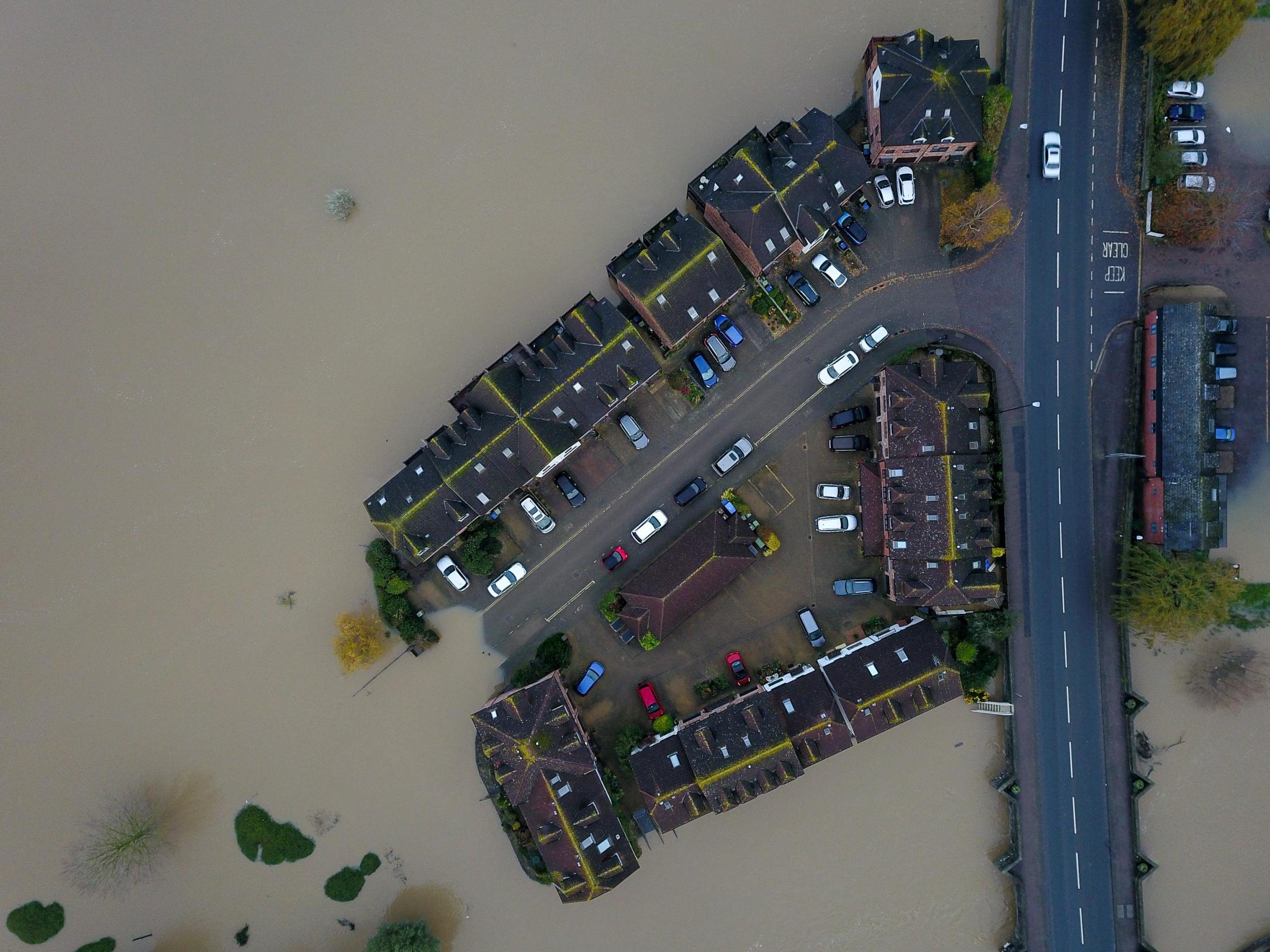
Homes in Gloucestershire and Worcestershire were left waterlogged over the weekend after the rivers Severn and Avon burst their banks.
Drone footage revealed the extent of the flood around the market town of Tewkesbury, where the two waterways meet.
Meanwhile residents in the midlands and Yorkshire are still struggling to clear their homes, as communities were urged to “stay vigilant”.
A total of 58 flood warnings requiring “immediate action” remained in force on Sunday afternoon, from Gloucester in the west of England to the River Hull in the east. There are also a further 90 lower-level flood alerts.
In its latest five-day forecast for England and Wales, the Environment Agency (EA) warned of a risk of continued flooding throughout the midlands and northern England.
“Ongoing flooding is also possible from rivers in parts of Worcestershire and Gloucestershire on Sunday,” it said.
“Local river flooding is expected to continue today in parts of Oxfordshire, until Monday in parts of Nottinghamshire and Lincolnshire and until Tuesday in South Yorkshire.
“Local flooding from groundwater is possible in North Lincolnshire for the next five days. Local surface water and river flooding is also possible in southwest England and the south of Wales on Thursday.”
The forecast comes after the Met Office revealed that its weather station in Sheffield had recorded its “wettest ever autumn” with 15 days of the meteorological season left.
The flooding began nearly two weeks ago after some parts of the country were deluged with a month’s worth of rain within the space of 24 hours.
However, the Met Office said that the coming week is “looking quite dry” but warned that there was a risk of a very cold start to Tuesday morning with potential temperatures of -5C.
“There’s light cloud and rain around in some of the areas in the north of England and also down in Shropshire and the West Midlands,” said meteorologist Sophie Yeomans.
“But there’s no long-lasting or heavy rain – it’s a good situation.”
The forecast for drier weather has raised hopes that authorities can channel their resources from emergency response into recovery efforts.
In Stratford-upon-Avon a team of EA workers removed a 200m-long flood barrier early in the morning to ensure shops and businesses did not lose out on Sunday trading.
The agency said it had protected over 21,000 properties from flooding using temporary barriers and water pumps, and predicted that homes in Fishlake should be free of water by Sunday.
Kate Marks, flood duty manager at the EA, said: “Our teams will continue to work around the clock maintaining flood defences, erecting temporary barriers, clearing river blockages and monitoring river levels.
“Every flooded home is a personal tragedy and our thoughts are with those who have been affected and those waiting to return to their homes.”
Additional reporting by Press Association
Join our commenting forum
Join thought-provoking conversations, follow other Independent readers and see their replies
Comments