Tube strike walking map: Avoid Underground chaos with this useful guide to overground routes between stations
Handy map shows how long it takes to walk to each station

Your support helps us to tell the story
From reproductive rights to climate change to Big Tech, The Independent is on the ground when the story is developing. Whether it's investigating the financials of Elon Musk's pro-Trump PAC or producing our latest documentary, 'The A Word', which shines a light on the American women fighting for reproductive rights, we know how important it is to parse out the facts from the messaging.
At such a critical moment in US history, we need reporters on the ground. Your donation allows us to keep sending journalists to speak to both sides of the story.
The Independent is trusted by Americans across the entire political spectrum. And unlike many other quality news outlets, we choose not to lock Americans out of our reporting and analysis with paywalls. We believe quality journalism should be available to everyone, paid for by those who can afford it.
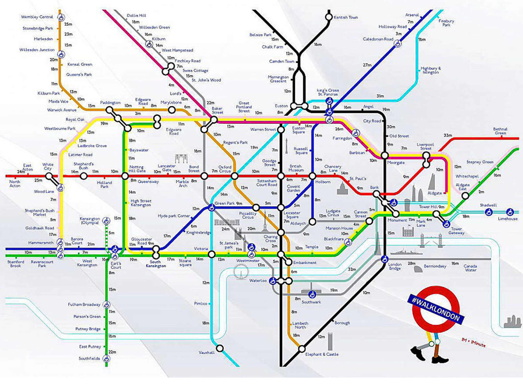
Your support makes all the difference.A walking Tube map has been created to show the walking distance between each stop for London commuters currently battling their way through the chaos of the 48-hour Tube strike.
London-based creative duo Joe Watson and Aryven Arasen have redesigned the traditional Tube map to show how long it takes to walk from each station after members of the Rail, Maritime and Transport Union (RMT) walked out at 9pm last night.
The map helps avoid queues such as those which built up when early rush-hour passengers waited until 7am for the first Tube trains to run.
At Euston station in north London, customers crowded around the entrance to the Underground, while at London's Victoria station, passengers pouring off mainline trains were confronted with a wall of people waiting for Tube services.
Read more: London commuters face 'severe disruption'
The map even lists famous landmarks across London which tourists may miss while travelling underground.
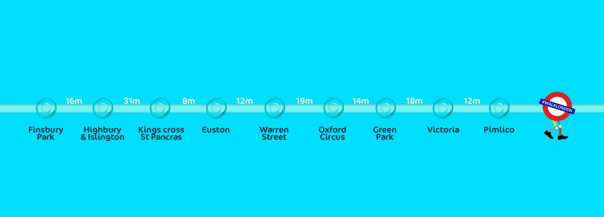
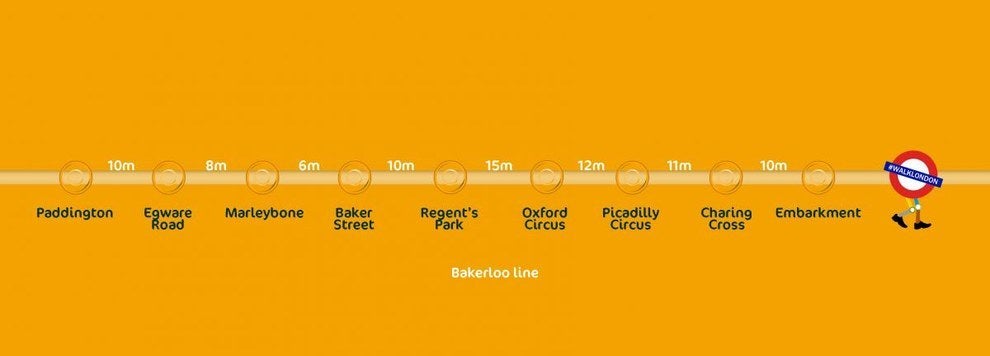
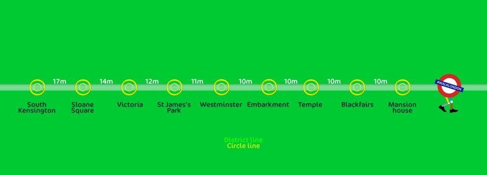
The pair have also created a series of infographics detailing the walking distance for closed lines, including the Victoria line and the Circle line.

On their website, the duo said: "We made a new Underground map that lets people know the distances between each station so that you can find the fastest way to work or wherever else you want to go during the strikes.

"It even tells you the locations of all the landmarks that you miss from tunneling in the dark so you can have a brighter start to the day."

The RMT say the closure of ticket offices will cost hundreds of job losses and threaten safety.
But London Underground maintains that staff would be better employed on station concourses as only 3 per cent of tickets are bought at ticket offices.
If the dispute is not resolved, RMT members say they will stage another walkout - this time for 72 hours - from 9pm on Monday 5 May.
TFL has produced a document of travel advice to customers and said it plans to run for extra bus and river services. But those services are expected to be very busy, and TFL is advising commuters to leave plenty of extra time to finish their journeys.
Join our commenting forum
Join thought-provoking conversations, follow other Independent readers and see their replies
Comments