Snow mapped: Where freezing weather and flooding will hit UK with more snow forecast
Heavy snow and rain causes widespread disruption as cold temperatures return this week
Your support helps us to tell the story
From reproductive rights to climate change to Big Tech, The Independent is on the ground when the story is developing. Whether it's investigating the financials of Elon Musk's pro-Trump PAC or producing our latest documentary, 'The A Word', which shines a light on the American women fighting for reproductive rights, we know how important it is to parse out the facts from the messaging.
At such a critical moment in US history, we need reporters on the ground. Your donation allows us to keep sending journalists to speak to both sides of the story.
The Independent is trusted by Americans across the entire political spectrum. And unlike many other quality news outlets, we choose not to lock Americans out of our reporting and analysis with paywalls. We believe quality journalism should be available to everyone, paid for by those who can afford it.
Your support makes all the difference.A number of weather warnings are in place for parts of the UK on Tuesday, as more snow is forecast to fall across the country and flooding is expected.
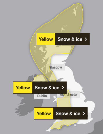
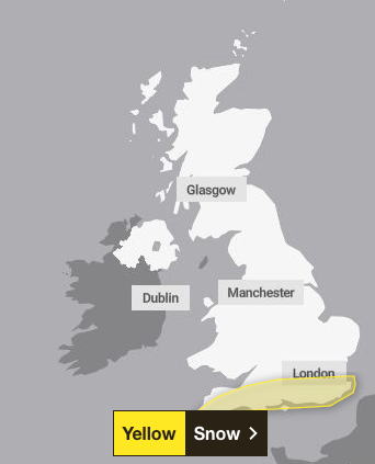
The Met Office has issued three new yellow snow and ice warnings and another snow alert over the next three days following a weekend of extreme weather.
A yellow snow and ice warning has been issued from 4pm on Monday to midday on Tuesday, covering northern Scotland and parts of western Scotland.
Another yellow snow and ice warning has been issued for Northern Ireland from 3pm on Monday until 11am on Tuesday.
A third yellow warning for snow and ice will come into effect at 5pm on Monday and will last until 10am on Tuesday, covering most of Wales and western England.
Meanwhile, a yellow snow warning covering much of southern England will last from 9am on Wednesday until the end of the day.
The fresh alerts come after a number of yellow warnings and an amber alert for snow all lifted on Monday.

Further weather warnings could be issued with the potential for some snow to fall in southern and central England and Wales around the middle of the week, the Met Office also said.
Cold air will return and remain across the whole country from Monday onwards after a brief spell of milder conditions in southern areas.
Deputy chief forecaster Mike Silverstone said: “The low pressure that brought the snow and heavy rain in the south will move out to the east by Monday. This will allow a cold northerly flow to become established again for much of next week.

“This will bring further sleet, snow and hail showers to northern Scotland in particular, but possibly to some other areas, especially near western coasts, with a fair amount of dry and bright weather elsewhere.
“Temperatures will remain below average, with widespread frost and the threat of ice at times. Some areas, especially in the north, may struggle to get above freezing for several days.”
The UK experienced its coldest night of the winter so far overnight on Sunday, with a temperature of -13.3C recorded in Loch Glascarnoch in the Highlands, between Ullapool and Inverness.

Many are suffering travel disruption from the severe weather on Monday, with major roads closed and railway lines blocked amid flooding.
Manchester airport’s runways were closed early on Monday morning because of heavy snow but have since reopened.
In England, the Environment Agency had 193 flood warnings in place across England on Monday evening, meaning flooding is expected, and another 306 flood alerts indicating flooding was possible.
The Prime Minister also urged the public to follow advice from the emergency services, thanking them for their work and saying his “thoughts are with all those affected”.
In the Commons, environment minister Emma Hardy told MPs flooding was “a personal priority” for her, adding that the Environment Agency was particularly concerned about Lincolnshire, Leicestershire, Warwickshire and Nottinghamshire.
Warning of further “localised” flooding to come over the next 24 to 36 hours, she pledged to overhaul the Government’s approach to funding flood defences “to ensure the challenges facing businesses and rural and coastal communities are taken into account when delivering flood protection.”

Join our commenting forum
Join thought-provoking conversations, follow other Independent readers and see their replies
Comments