Where snow could hit UK on New Year’s Day
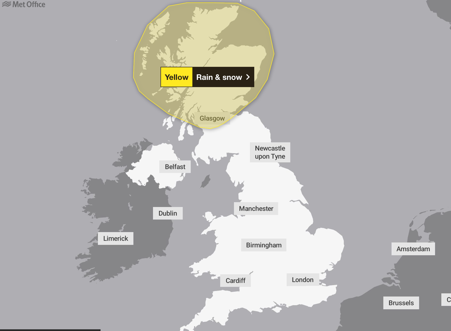
The Met Office has issued a yellow rain and snow warning that will be in force for the whole of Monday and Tuesday
Your support helps us to tell the story
From reproductive rights to climate change to Big Tech, The Independent is on the ground when the story is developing. Whether it's investigating the financials of Elon Musk's pro-Trump PAC or producing our latest documentary, 'The A Word', which shines a light on the American women fighting for reproductive rights, we know how important it is to parse out the facts from the messaging.
At such a critical moment in US history, we need reporters on the ground. Your donation allows us to keep sending journalists to speak to both sides of the story.
The Independent is trusted by Americans across the entire political spectrum. And unlike many other quality news outlets, we choose not to lock Americans out of our reporting and analysis with paywalls. We believe quality journalism should be available to everyone, paid for by those who can afford it.
Your support makes all the difference.Britons are bracing for snowfall and a sharp drop in temperatures, which are set to fall to -2C on New Year’s Eve in some places.
The Met Office has issued a yellow rain and snow warning that will be in force for the whole of Monday and Tuesday.
It comes after severe fog caused travel chaos after Christmas with dozens of flights delayed or cancelled across the UK.
The yellow warning covers large parts of Scotland, including Glasgow, Edinburgh, Perth, Inverness and Aberdeen.
The forecaster said on Monday in the north and east of Perthshire, precipitation is likely to fall as snow, especially over high ground, with 10cm to 20cm accumulating above 150 metres to 200 metres.

It added 50 to 70mm of rain is possible over the two days in many areas, while some places may see 100-140mm – with these higher totals most likely over western Scotland.
Some areas may also see snow, especially in northern Scotland and over high ground, while strong winds could bring further disruption, particularly on New Year’s Eve.
A yellow warning for “persistent snow” likely to cause travel disruption has been issued for Orkney and Shetland during Hogmanay.
The Met Office alert covers all of the islands and is in place from 5am all day on Tuesday.
Up to 20cm of snow is expected in the worst affected areas, mainly Mainland and Hoy, with 5 to 10cm predicted elsewhere.
Longer road journey times are likely as a result of difficult driving conditions, the forecaster warned.
As milder air pushes in, snow will turn back to rain, and any rapid snow melt will contribute to flooding in places.
The Met Office has warned spray and flooding will lead to difficult driving conditions and some road closures, with longer journey times by road, bus and train services.
Fast-flowing or deep floodwater is possible, causing a danger to life.
Delays or cancellations to train and bus services are possible from rain or snow, the forecaster said.

The Met Office said: “Rain is likely to become persistent and occasionally heavy on Monday and possibly last through New Year’s Eve.
“This may bring some significant disruption and flooding in the build-up to new year events, although there is still a lot of uncertainty in which areas are likely to be affected.”
From New Year’s Day the unsettled conditions, and potentially disruptive wind, rain and snow, could affect more southern parts of the UK.
Met Office meteorologist Simon Partridge said: “Basically, the North East seems to be the place to be for the next couple of days if you want to see some brighter and maybe even some blue sky at times, whereas elsewhere is mainly grey.”
Over the weekend it will become “a little bit windier and a little bit wetter” across Scotland, with showers in northern Scotland as a result of low pressure, he said.
Further south it will be “pretty cloudy” with some breaks in the cloud on Sunday because of slightly stronger winds.
Temperatures at the weekend may be “slightly fresher” with highs of about 9C to 11C expected, compared with 11C to 13C earlier in the week, though it will still be fairly mild for the time of year including overnight, with little frost expected.
But Mr Partridge added: “As we head towards the new year, particularly for New Year’s Eve, it looks like there could be some wet and rather windy weather, particularly across Scotland, which is not ideal considering that’s the place that really goes to town for New Year’s Eve.”

Join our commenting forum
Join thought-provoking conversations, follow other Independent readers and see their replies
Comments