Mapped: Where Met Office weather warnings for 80mph winds will hit UK as Christmas holidays begin
Met Office says area of low pressure will bring rain and strong winds across large swathes of the UK
Your support helps us to tell the story
From reproductive rights to climate change to Big Tech, The Independent is on the ground when the story is developing. Whether it's investigating the financials of Elon Musk's pro-Trump PAC or producing our latest documentary, 'The A Word', which shines a light on the American women fighting for reproductive rights, we know how important it is to parse out the facts from the messaging.
At such a critical moment in US history, we need reporters on the ground. Your donation allows us to keep sending journalists to speak to both sides of the story.
The Independent is trusted by Americans across the entire political spectrum. And unlike many other quality news outlets, we choose not to lock Americans out of our reporting and analysis with paywalls. We believe quality journalism should be available to everyone, paid for by those who can afford it.
Your support makes all the difference.The UK is set to see rain and disruptive winds of up to 80mph this weekend as the Met Office issues weather warnings for Christmas holiday drivers.
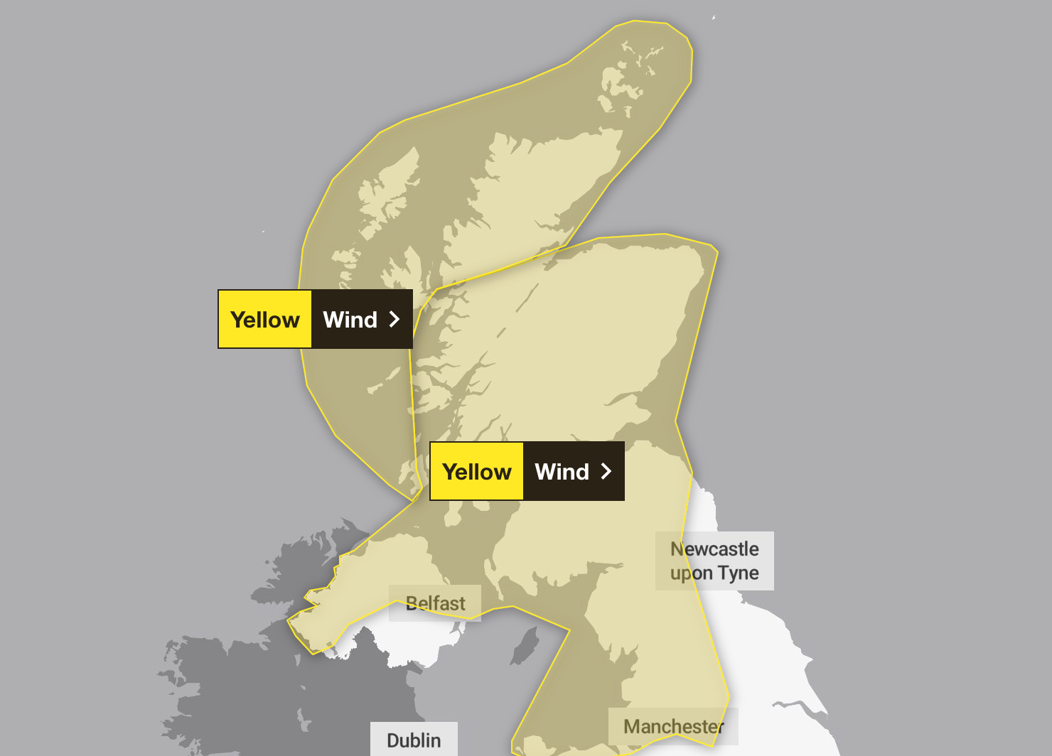
Yellow wind warnings have been released for the weekend, with one covering Scotland, much of Northern Ireland, north Wales and north-west England between 7am and midnight on Saturday.
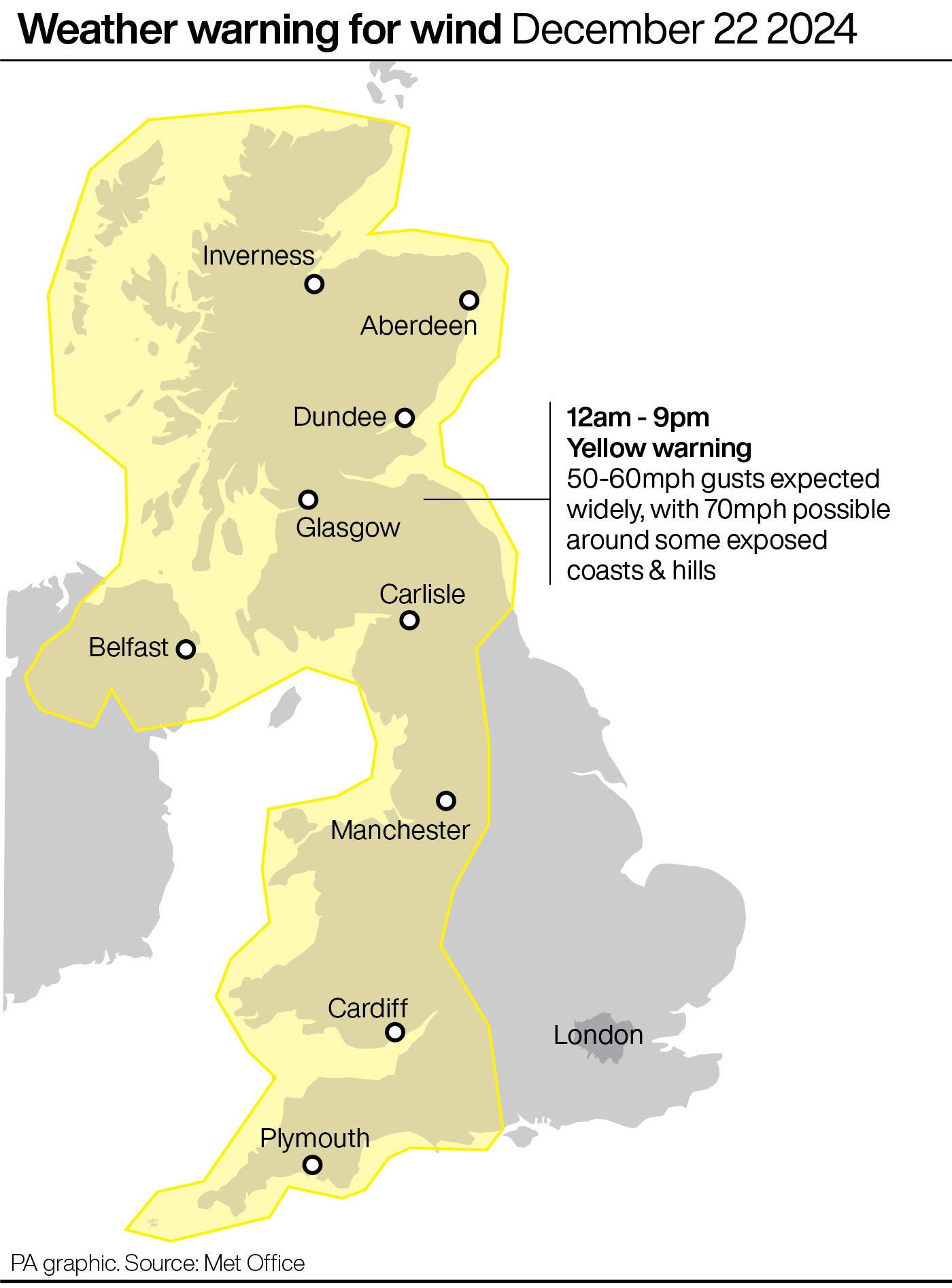
Sunday’s warning also includes London, the South East, the South West, the East Midlands, the West Midlands, Yorkshire and all of Wales and Northern Ireland.
Winds of up to 85mph could hit coastal areas across northern Scotland on Saturday afternoon and evening, with more widespread gusts of 50 to 60mph on Sunday.
Follow our Christmas travel live blog here for the latest updates

An area of low pressure will cross the far north of the UK on Saturday bringing rain and strong winds across large swathes of the UK, the forecaster said.
Road, rail, air and ferry services in Scotland are all likely to be affected by the weather conditions, Transport Scotland said.
The Met Office said: “The strongest winds are expected across the far north of Scotland on Saturday afternoon and evening, with the potential for gusts in excess of 80mph in coastal districts including Orkney.
“Dangerous coastal conditions can be expected too, with large waves an additional hazard, especially in respect to causeways. This period of strong winds may lead to some transport disruption, including ferry delays or cancellations.
“Frequent blustery showers will also be a feature on Saturday and may merge into a longer spell of rain for a time in the far north and north west.”

It comes as drivers have been urged not to travel on major routes for six hours on both Friday and Saturday to avoid the worst of the Christmas holiday traffic.
It comes as the RAC estimated seven million leisure trips will be made on major roads during the weekend, which excludes everyday traffic.
Hotspots where queues are expected include the M3 between its junction with the M25 and the south coast, the M25 anticlockwise between its junctions with the M1 and the M23, and the M53 from Chester to Liverpool.
RAC spokesperson Rod Dennis said: “With the weekend bringing a mix of strong winds along with heavy, and in some places wintry, showers, it’s going to make many of the estimated seven million getaway trips by car a pretty exhausting experience.”
He added: “Gusty winds, and heavy showers in the north and west of the UK, are going to make millions of getaway trips by car all the more arduous this weekend.

“We understand it’s nearly Christmas and many people will be eager to get to their destinations, but our advice to drivers is to slow down, leave more space behind the car in front and be wary of the impact sudden strong gusts of wind can have.
“In these challenging conditions, it’s vital to keep both hands on the wheel and watch out for high-sided vehicles that could potentially be blown off course.
“Those whose journeys involve using major bridges should allow extra time in case they are closed for safety reasons. Carrying an emergency breakdown kit in the boot is also important – sturdy shoes, warm clothes, waterproofs and a fully-charged mobile power bank with cable are all must-haves.”
The winds will ease at the start of next week but there will be further rain moving east across the UK on Monday night, the Met Office said.
Christmas Eve will be a mild, blustery day with further rain or drizzle at times in the west and the best chance of sunny spells in the east.
Christmas Day itself is likely to be settled, mostly cloudy and dry, although strong winds and spells of rain are likely in the far north. Temperatures are expected to be widely very mild, with the chance of a white Christmas looking slim, the forecaster added.

Join our commenting forum
Join thought-provoking conversations, follow other Independent readers and see their replies
Comments