Hurricane Kirk could bring heavy wind and strong winds to UK, Met Office warns
Remnants of storm system could bring up to 15cm of rainfall to huge swathes of the UK

Your support helps us to tell the story
From reproductive rights to climate change to Big Tech, The Independent is on the ground when the story is developing. Whether it's investigating the financials of Elon Musk's pro-Trump PAC or producing our latest documentary, 'The A Word', which shines a light on the American women fighting for reproductive rights, we know how important it is to parse out the facts from the messaging.
At such a critical moment in US history, we need reporters on the ground. Your donation allows us to keep sending journalists to speak to both sides of the story.
The Independent is trusted by Americans across the entire political spectrum. And unlike many other quality news outlets, we choose not to lock Americans out of our reporting and analysis with paywalls. We believe quality journalism should be available to everyone, paid for by those who can afford it.
Your support makes all the difference.A major hurricane gathering force in the Atlantic could lead to heavy rain and wind in the UK next week, the Met Office has warned.
Hurricane Kirk has seen winds of up to 125 mph according to the US National Hurricane Center, and is expected to strengthen over the coming days. It has already been named a Category 3 storm by the agency, with the latest guidance indicating it will gradually turn north-west.
While it is not headed directly to the UK, the impacts of Kirk could still be felt in the country. The Met Office says that the hurricane is causing “uncertainty” in the forecast, with several scenarios put forward.
Meteorologist Tony Wisson explains: “Hurricane Kirk is currently in the tropical Atlantic. It is expected to move north into cooler waters, where it will lose a lot of its strength, but maintain its identity as a moderately deep low pressure system.
“There are complex processes involved when a hurricane undergoes what is known as ‘extra tropical transition’. This results in a lot of variability in the forecast, which means that predictability is low at longer lead times. Therefore, confidence in any one scenario is very low.”
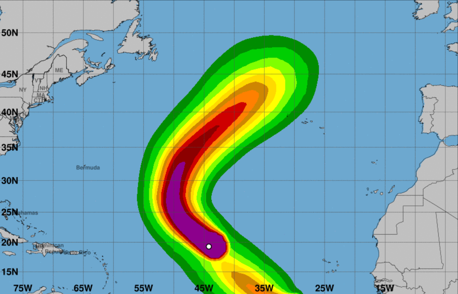
The Met Office expert says that the low pressure system caused by Kirk could approach or possibly cross the UK by Wednesday or Thursday next week. This would lead to “heavy rain and strong winds,” he says.
If this system stays away from the UK, wet and windy weather is less likely. However, a longer timescale forecast by UK-based MetDesk predicts that very heavy rain will reach the country by Thursday evening.
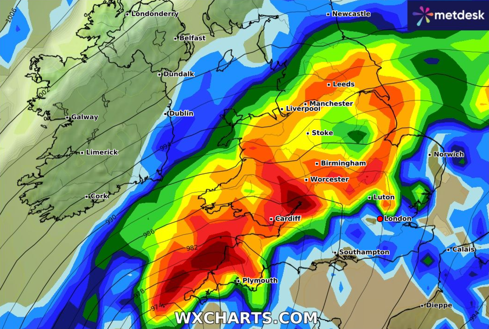
This deluge could stretch nearly 400 miles, hitting both Plymouth and Leeds at the same time and could cause up to 15cm of rainfall.
Fortunately, any scenario would see Kirk lose its hurricane status, as it is firmly predicted to lose strength by next week. The Met Office says if it were to cross the UK at this point, it would be called “ex-Hurricane Kirk.”
Join our commenting forum
Join thought-provoking conversations, follow other Independent readers and see their replies
Comments