Melting glaciers caught in incredible time-lapse photographs show climate change in action
James Balog documents impact of global warming with astonishing images on behalf of Geological Society of America

Your support helps us to tell the story
From reproductive rights to climate change to Big Tech, The Independent is on the ground when the story is developing. Whether it's investigating the financials of Elon Musk's pro-Trump PAC or producing our latest documentary, 'The A Word', which shines a light on the American women fighting for reproductive rights, we know how important it is to parse out the facts from the messaging.
At such a critical moment in US history, we need reporters on the ground. Your donation allows us to keep sending journalists to speak to both sides of the story.
The Independent is trusted by Americans across the entire political spectrum. And unlike many other quality news outlets, we choose not to lock Americans out of our reporting and analysis with paywalls. We believe quality journalism should be available to everyone, paid for by those who can afford it.
Your support makes all the difference.Melting glaciers, from Greenland to Antarctica, have become symbols of global warming — and monitoring their retreat is one major way scientists are keeping tabs on the progress of climate change.
Now, scientists are trying to bring the issue a little closer to home by using time-lapse photos to show the effects of climate change are already occurring.
A paper published last week by the Geological Society of America presents dramatic before-and-after photographs of glaciers around the world over the last decade. Most of the photos were taken by photographer James Balog as part of a project called the Extreme Ice Survey, which began documenting changing glaciers around the world in 2007. The project was featured in the 2012 documentary Chasing Ice.
Below is a time-lapse video, using images captured by Balog and the Extreme Ice Survey team, documenting changes at Mendenhall Glacier in Alaska. Between 2007 and 2015, the glacier retreated by 550 metres, or more than 1,800 feet.
On-the-ground expeditions are “key to informing broad audiences of non-specialists,” note the paper’s authors, who include Balog and multiple other glacier and climate experts. “Science is grounded in observation, so science education will benefit from displaying the recently exposed landscapes.”
In an interview with The Washington Post, Balog suggested that ground-level photographs provide an immediacy that’s missing from other scientific tools, such as satellite images.
“I do think that our most dominant sensory apparatus is our vision,” he added. “So when you can deliver an understanding of the reality of what’s going on through vision, rather than numbers or maps, that also has the unique ability to touch and influence people.”
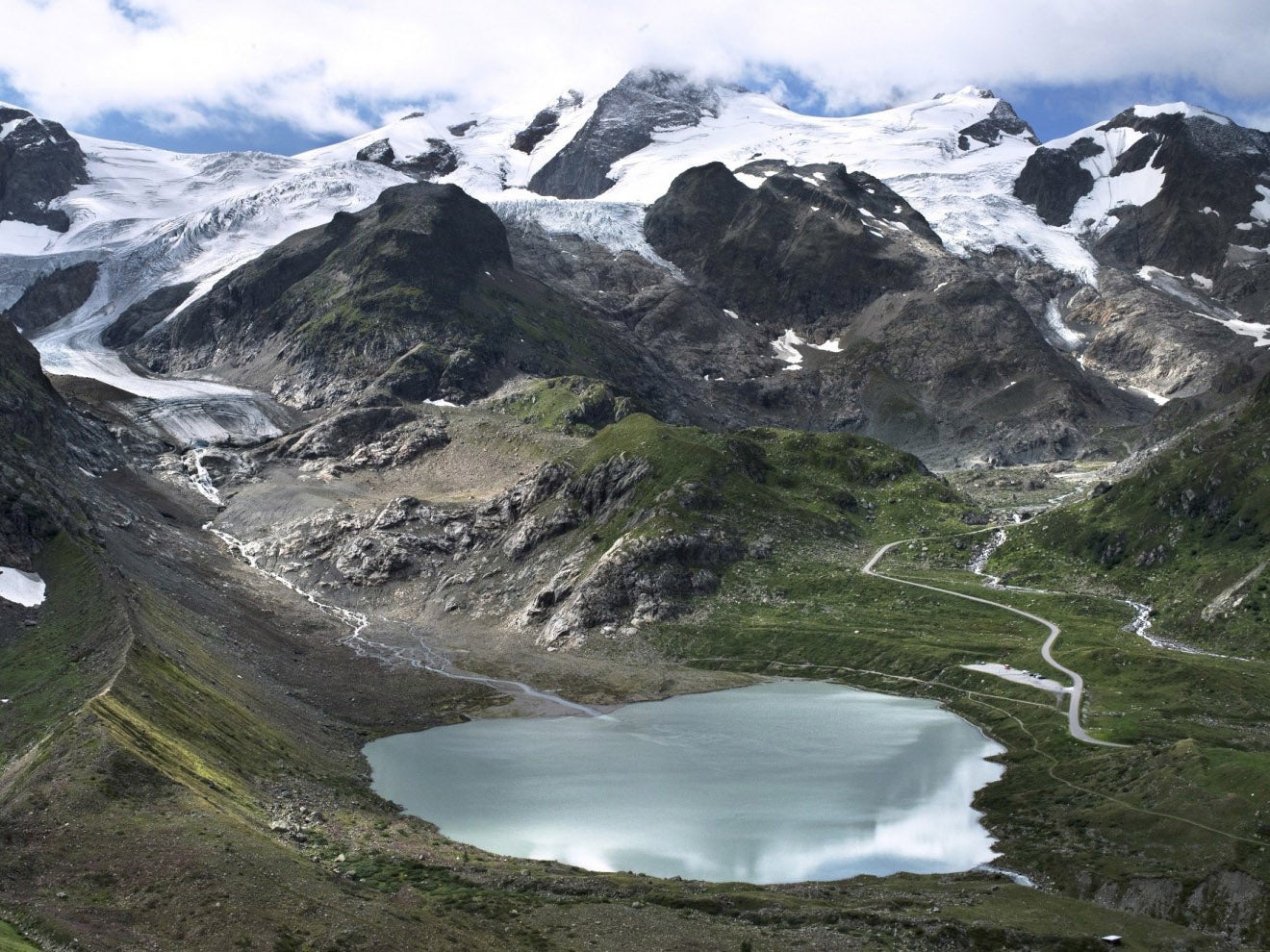
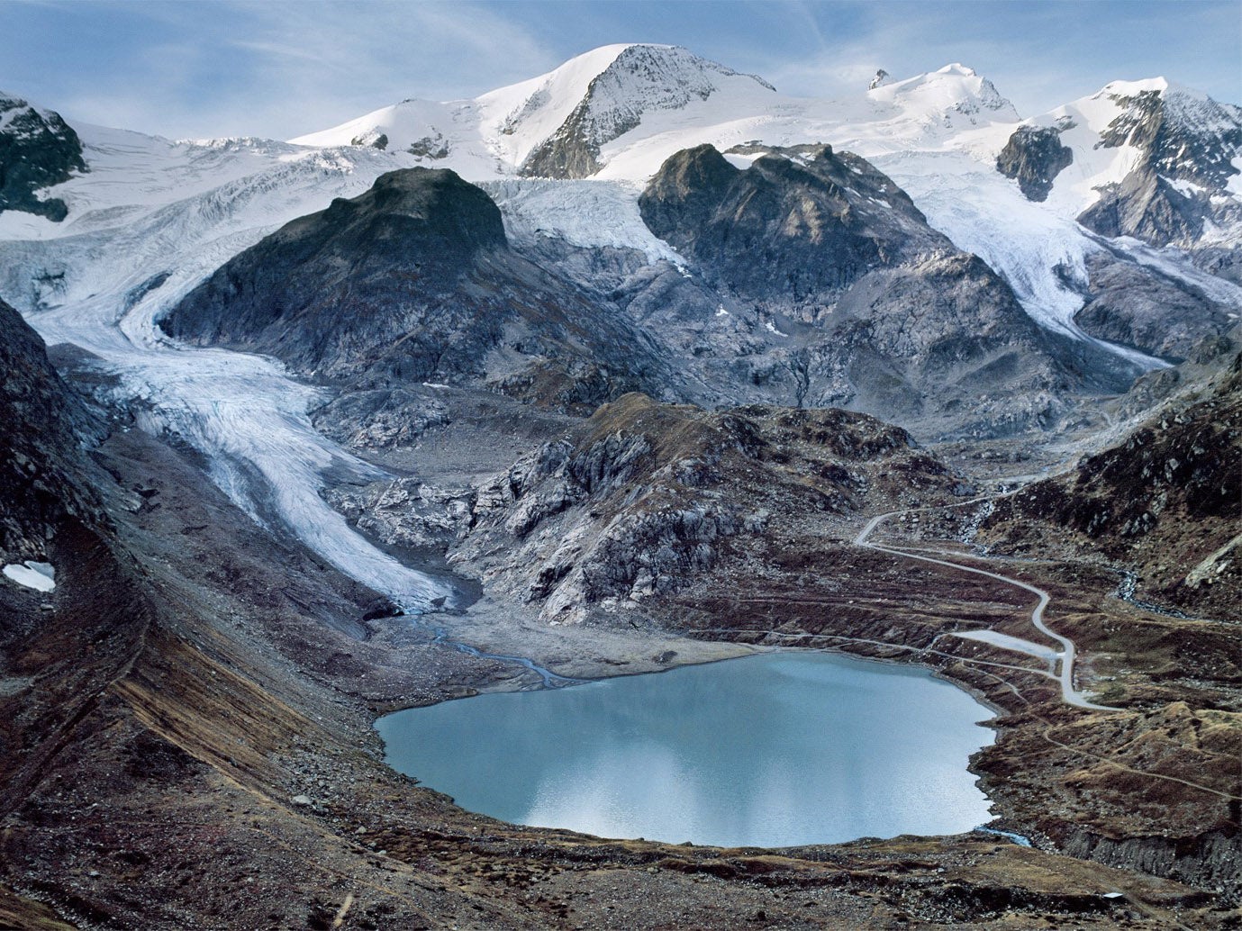
Below are before-and-after images of Switzerland’s Stein Glacier, which also retreated by 550 metres between 2006 and 2015.


For Balog, the location that’s had the greatest personal impact is Sólheimajökull Glacier in Iceland, which he described as his “first love.”
“It’s where I kind of first realised how quickly the ice is changing,” he said. “And it’s because of what the local scientists were able to show me by way of the change in the glacier in a shockingly short period of time.”
Reports suggest that the glacier has shrunk by more than 2,000 feet since 2007. Below is a time-lapse of its retreat between 2007 and 2015.
While the Greenland and Antarctic ice sheets often receive the most press — and not without reason, thanks to the sheer amount of ice they contain — Balog’s photos include smaller mountain glaciers from places like Alaska and Europe. In many places around the world, these smaller glaciers are responding even more rapidly to their changing environments than their polar counterparts.
And while the Greenland and Antarctic ice sheets may have the greatest long-term potential to raise global sea levels, melting mountain glaciers come with their own set of consequences as well. Nearby communities often rely on runoff from these glaciers for sources of fresh water. But as the glaciers shrink away, less water becomes available. Some experts have also raised the possibility that melting mountain glaciers could result in huge floods capable of destroying nearby homes and infrastructure.
“People who live in proximity to these things are really are quite acutely aware of how much things are changing and think about it, and the researchers in their areas study it,” Balog said. “These are important and immediate impacts.”
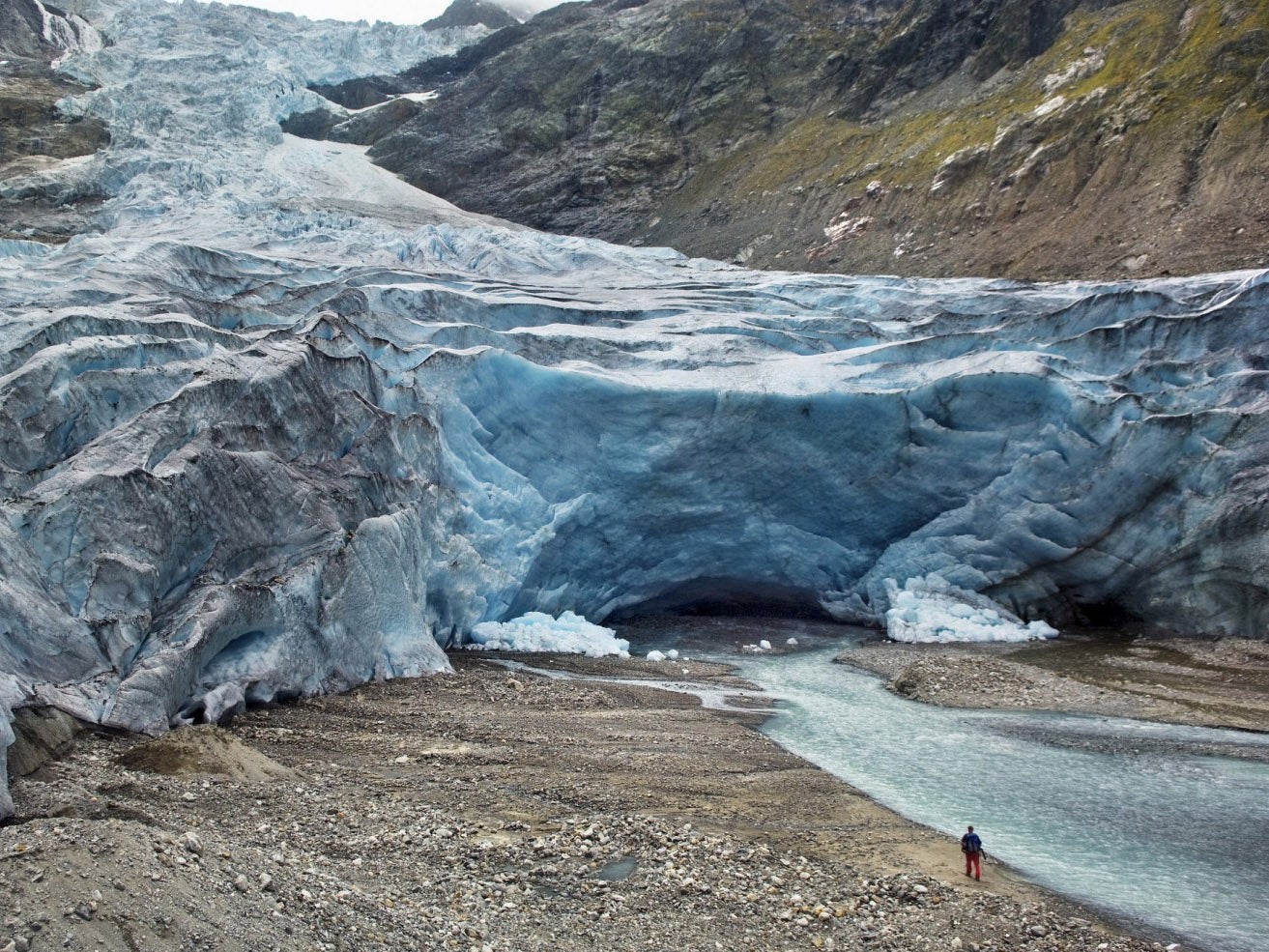
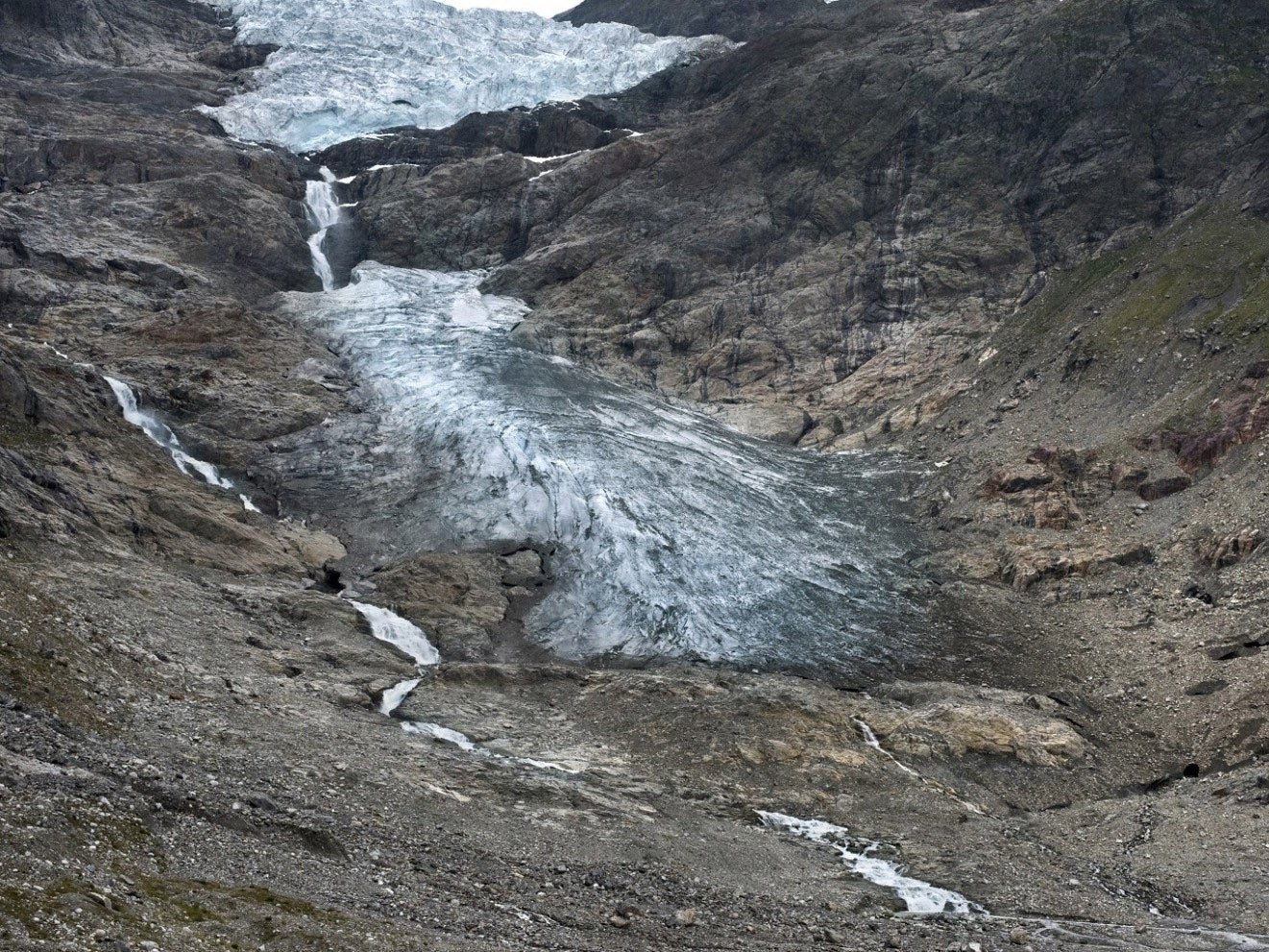
Below is Trift Glacier, which retreated by more than 3,700 feet between 2006 and 2016.


Satellite measurements still provide some of the most precise information on glacial retreat all over the world, revealing the vulnerability of the Greenland and West Antarctic ice sheets. Scientists have used satellite data to estimate how much ice these sheets contain in total. (If the Greenland and Antarctic ice sheets melted away entirely, for instance, they could raise sea levels by more than 200 feet. But it would take tens of thousands of years for that to happen, even at current warming rates.)
On-the-ground imagery provides a different kind of service, presenting compelling visual evidence of the climate effects that are already occurring. And the photos have an added visceral effect because they come from places where human communities exist — it’s not just ice on deserted Antarctica that’s disappearing, but also glaciers from Europe and the Americas to Asia and Africa. And once they’re gone, they may never exist again.
“It is likely that these recently deglaciated landscapes will not be re-occupied by ice during foreseeable human time frames,” the paper’s authors warn. “In other places, forests or other vegetation may rapidly colonise such landscapes. Photographic records, such as those included here, provide an outstanding avenue for education, because they display a record of ice that may never be seen again.”
The Washington Post
Join our commenting forum
Join thought-provoking conversations, follow other Independent readers and see their replies
Comments