Fracking shame: Full threat to British wildlife is laid bare in a new report showing up to half the country could be licensed for shale gas extraction

Your support helps us to tell the story
From reproductive rights to climate change to Big Tech, The Independent is on the ground when the story is developing. Whether it's investigating the financials of Elon Musk's pro-Trump PAC or producing our latest documentary, 'The A Word', which shines a light on the American women fighting for reproductive rights, we know how important it is to parse out the facts from the messaging.
At such a critical moment in US history, we need reporters on the ground. Your donation allows us to keep sending journalists to speak to both sides of the story.
The Independent is trusted by Americans across the entire political spectrum. And unlike many other quality news outlets, we choose not to lock Americans out of our reporting and analysis with paywalls. We believe quality journalism should be available to everyone, paid for by those who can afford it.
Your support makes all the difference.The threat posed to wildlife by fracking is laid bare today as a new report identifies vast swathes of environmentally sensitive land across Britain that could be excavated for shale oil and gas.
The land covers tens of thousands of square kilometres and includes thousands of sites such as Morecombe Bay in the North West, one of the most important areas in Europe for hosting wintering birds, as well as the North York Moors and the Thames Estuary.
An alliance of wildlife groups including RSPB and the National Trust is calling on the government to establish “frack-free zones” across the country to protect areas of particular environmental importance.
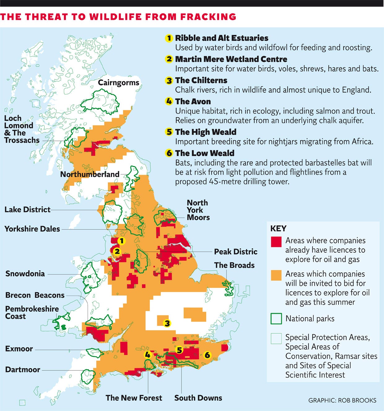
The proposed zones would cover a total area of about 42,000 square kilometres – or about 18 per cent of Britain. Some of them are already under threat from licences previously granted to fracking companies, some could be put at risk from licences due to be auctioned in a giant licensing round this summer, while others are not currently in any danger. The so-called 14th licensing round in the summer potentially covers about 40 per cent of Britain, although experts expect only a fraction of this will end up being licensed – at least this time round, as gas companies initially compete for the most attractive locations.
Click image above to enlarge graphic
The zones cover all protected wildlife areas, nature reserves and national parks. The alliance is also calling for full environmental assessments to be carried out for each drilling proposal and for the shale gas industry to pay the costs of its regulation and any pollution clean-ups.
Martin Harper, RSPB's conservation director, said: “The Prime Minister has been a great advocate for the shale gas industry. He has said we have the strongest environmental controls in this country and nothing will go ahead if there are environmental dangers.”
Some 481 environmentally sensitive sites fall within areas currently under licence, meaning that oil and gas companies are already free to develop the site, although any development will be contingent on finding commercially-viable quantities of oil or gas to extract. A further 2,676 sites fall within areas that will come up for auction in the summer licensing round.

The environmentally-sensitive areas include RSPB and National Trust grounds, sites of special scientific interest (SSSI), special protection areas (SPA) and special areas of conservation (SAC).
Fracking is a controversial process that releases oil or gas from shale by blasting a mixture of sand, chemicals and water into the rock. It has been linked to earthquakes and water pollution, although the UK government has decided to permit the technique under strict environmental and operational regulations. The industry is currently in the very early stages and commercial fracking has yet to begin, but the government is hoping shale gas production can become widespread next decade.
A spokesperson for the Department for Energy and Climate Change (DECC) said it was not necessary to establish frack-free zones because the necessary procedures were already in place to protect the most environmentally-sensitive areas.
“Councils are best placed to decide if fracking is suitable in their local area and an environmental impact assessment is likely to be required in designated areas. Rather than having a blanket ban on certain areas, planning authorities will assess each application on a case by case basis, including those parts of the country where there is a general presumption against development,” the spokesperson said.
“We also have regulations in place to ensure on-site safety, prevent water contamination, mitigate seismic activity and air pollution and we have been successfully regulating for gas and oil drilling for over 50 years,” the spokesperson added.
The Angling Trust, the Salmon and Trout Association, The Wildlife Trusts and the Wildfowl & Wetlands Trust are the other members of the alliance.
The areas that could be threatened by fracking: the alliance makes its case
The Avon
The Hampshire Avon is one of England’s most iconic rivers. Its rich ecology, including salmon and trout that are highly prized by anglers, relies on cool, clear groundwater from an underlying chalk aquifer. England is home to 85 per cent of the world’s chalk streams and the Hampshire Avon has the highest levels of legal protection in an attempt to preserve this unique habitat. Despite the unique character of the Avon, Government are considering licensing the area for shale gas – with associated risks from pollution and water abstraction.
In the forthcoming licensing round
Nightjars in the High Weald
The High Weald is an ancient landscape of rolling hills, meadows and heath that in Spring welcomes churring nightjars back from Africa where they spend the winter. Nightjars are known from a number of studies to be highly vulnerable to disturbance at breeding sites. The High Weald lies within the current and prospective shale gas license zones; exploitation of shale gas in this area threatens to increase the disturbance to this internationally important population of nightjars.
The Western half is already licensed, the Eastern half is in the next license round
The Wildfowl & Wetlands Trust’s (WWT) Martin Mere Wetland Centre in Lancashire
This is a low-lying wetland area of open-water, marsh and grassland overlying deep peat deposits. WWT’s Wetland Centre gives millions of people from towns and cities in the northwest an opportunity to connect with nature. In winter Martin Mere is an important overwintering site for migrating water birds like whooper swans and pink footed geese who graze across the wetland in their thousands. In spring the grass is full of ground nesting waders raising their chicks – species like redshank, lapwing and snipe.
Martin Mere is important for wildflowers – WWT is creating large areas of whorled caraway, a western Britain specialist. Visitors can also see water shrew, water vole, brown hare and a range of bat species who feed on the vibrant moth population. The site has many designations and protections to preserve its natural value. If the chemicals used in fracking were to pollute the water supply, the whole site could be damaged or die and the wildlife with it. The same could happen if seismic activity or water extraction lowers the water table. Thousands of families would lose a safe place to visit to see native wildlife. There’s also a concern that preparatory work could scare the birds, which can be fatal for migratory species who need to balance their long migration against sufficient time resting and feeding.
Already licensed
Chiltern Chalk
The Chilterns Area of Outstanding Beauty is defined by its chalk geology. This chalk is prized as a source of clean drinking water and has supported the development of London and its satellite towns for over a century. It is also home to nine chalk rivers - rich in wildlife and almost unique to England. Existing demands for water supply mean these rivers are already suffering from over-abstraction and the expansion of fracking, with its intensive thirst for water, could exacerbate those problems. The potential for pollution caused by methane escaping from poorly constructed fracking wells and accidental loss of flowback fluids rich in salts and naturally occurring radioactive materials poses a risk to wildlife and drinking water.
Southern half is in the forthcoming licensing round
Ribble and Alt Estuaries
The Ribble and Alt Estuaries Special Protection Area (SPA) is part of a chain of fantastic coastal sites along the northwest coast of England that is used by waterbirds and wildfowl such as geese, swans, ducks and waders for feeding and roosting. The site consists of two estuaries, plus an extensive area of sandy foreshore. It is host to sand- and mud-flats, coastal grazing marsh and, particularly in the Ribble Estuary, large areas of saltmarsh.
Several species feed on areas of agricultural land outside the SPA boundary, most notably the Pink-footed Goose which is one of the UK’s most internationally important species of bird with 85 per cent of the global population overwintering in Britain. In recent years, 14 per cent of that global population has used the Ribble and Alt Estuaries – that’s an average of just under 60,000 birds each year. Exploiting the shale gas that underlies this important goose-feeding area would necessitate numerous shale gas wells that would introduce disturbance into an area that is currently relatively peaceful. High levels of disturbance could even cause pink-footed geese to desert this area altogether.
The Ribble Estuary is licensed, and the Alt Estuary is in the forthcoming round
Bats in the Low Weald
The Low Weald of Sussex and Surrey is an area of lowlying and gently rolling clay vales beneath a patchwork of small woodlands, fields and hedgerows. The area is particularly important for bats, including the rare and protected barbastelle bat. Barbastelles roost in woodlands and fly out nightly along woody corridors to wet grassland feeding areas. Recently submitted plans for exploratory drilling in the Weald Basin included proposals for a 45-metre tower, which would be lit up 24 hours a day. Bats are vulnerable to light pollution such as this as it can displace activity and cut off flightlines between feeding and roosting sites, a problem which has been identified as a major risk to bat populations.
Part is already licensed and the remainder is in the forthcoming licensing round
Join our commenting forum
Join thought-provoking conversations, follow other Independent readers and see their replies
Comments