Real-time satellite observations reveal how wildfires devastated the planet in 2021
Summer of 2021 saw severe blazes in North America, Siberia, Mediterranean, and North Africa
Your support helps us to tell the story
From reproductive rights to climate change to Big Tech, The Independent is on the ground when the story is developing. Whether it's investigating the financials of Elon Musk's pro-Trump PAC or producing our latest documentary, 'The A Word', which shines a light on the American women fighting for reproductive rights, we know how important it is to parse out the facts from the messaging.
At such a critical moment in US history, we need reporters on the ground. Your donation allows us to keep sending journalists to speak to both sides of the story.
The Independent is trusted by Americans across the entire political spectrum. And unlike many other quality news outlets, we choose not to lock Americans out of our reporting and analysis with paywalls. We believe quality journalism should be available to everyone, paid for by those who can afford it.
Your support makes all the difference.The spread of extreme and sustained wildfires across vast areas of the planet in 2021 has been captured by real-time satellite observations.
The data was collected by Copernicus Atmosphere Monitoring Service (CAMS) from the European Centre for Medium-Range Weather Forecasts (ECMWF), allowing wildfire emissions to be estimated in near real-time, along with the impact on air quality.
Global wildfires caused an estimated total of 1,760 megatonnes (Mt) of carbon emissions to be pumped into the atmosphere this year - equivalent to 6,450 Mt of carbon dioxide (CO2). For context, CO2 emissions from fossil fuels in the European Union last year were 2,600Mt, CAMS reported, so 2021’s wildfires emitted 148 per cent more than that total.
Extreme heat and drought conditions driven by the climate crisis are fueling larger and more unpredictable wildfires.
The summer of 2021 was particularly dire with fires erupting across large areas of North America, Siberia, eastern and central Mediterranean, and North Africa.
August’s total estimated emissions were the highest of the year, with an estimated 378Mt of carbon released into the atmosphere globally. More than half of the emissions came from fires in North America and Siberia, two of the worst affected regions.
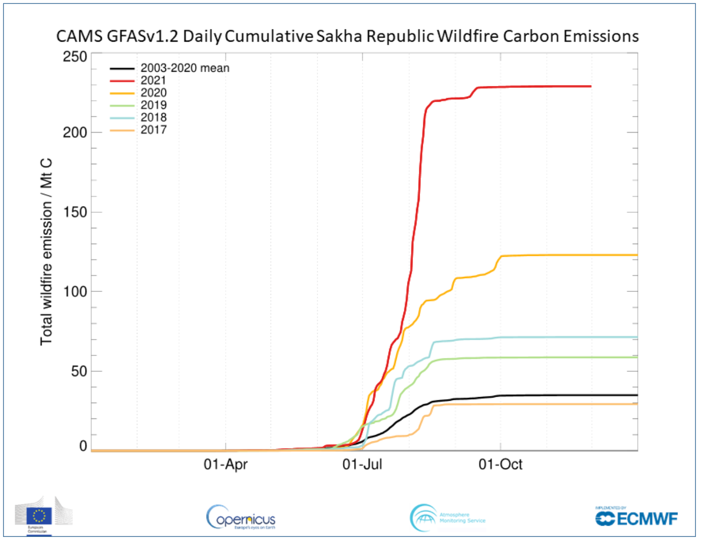
Wildfires in the Sakha Republic, northeastern Siberia, set the highest summer-time total from June to August, and was more than double previous years, according to CAMS 19-year, Global Fire Assimilation System (GFAS) dataset.

Following an unprecedented level of blazes in 2020, this summer saw wildfires explode across western parts of North America.
The Canadian province of British Columbia was badly impacted following a deadly heatwave in the region at the beginning of summer. A fire on 30 June wiped out the small town of Lytton, BC, and caused two deaths.
In July, California recorded its largest fire in state history, the Dixie Fire. It’s also believed to be the first to crest the Sierra Nevada mountain range.
The high intensity and persistence of US wildfire emissions was captured in satellite observations as a large plume of smoke, which crossed the Atlantic Ocean before mixing with wildfire smoke from Siberia, and drifting to the UK and across Europe.
In eastern and central Mediterranean countries, there were several days of extreme wildfires in July and August, leading to high concentrations of fine particulate matter (known as PM2.5) and degraded air quality.
This summer saw extreme drought and high temperatures in parts of Europe, creating a perfect storm of conditions for severe blazes.
Turkey was devastated by wildfires in July and severe impacts were also felt in Greece, Italy, Albania, North Macedonia, Spain, Algeria and Tunisia.
In late September, the annual seasonal crop stubble burning begins in Pakistan and north-western India. CAMS reported that the haze and smoke pollution led to very high concentrations of air pollution including PM2.5, impacting millions of people. Wildfires were most severe in the Indian states of Punjab and Haryana.
“As the year draws to a close, we have seen extensive regions experience intense and prolonged wildfire activity, some of which has been at a level not observed in the last couple of decades, said Mark Parrington, senior scientist and wildfire expert at the ECMWF Copernicus Atmosphere Monitoring Service.
“Drier and hotter regional conditions caused by global warming increase the risk of flammability and fire risk of vegetation and this has been reflected in the extremely large, fast-developing and persistent fires we have been monitoring.”
This article has been updated to clarify an error from the original report in a comparison made with 2021 global wildfire emissions
Join our commenting forum
Join thought-provoking conversations, follow other Independent readers and see their replies
Comments