US drought predicted to worsen this spring as dry conditions spread to nearly 60 per cent of the country
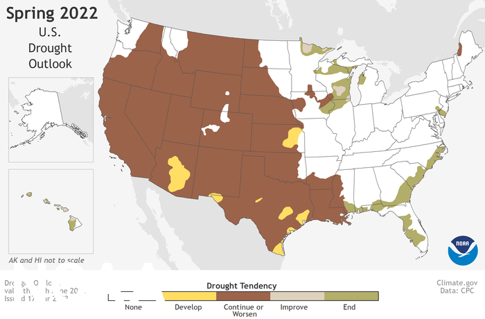
The US National Weather Service predicts ‘continuing or worsening drought’ across much of the country
Your support helps us to tell the story
From reproductive rights to climate change to Big Tech, The Independent is on the ground when the story is developing. Whether it's investigating the financials of Elon Musk's pro-Trump PAC or producing our latest documentary, 'The A Word', which shines a light on the American women fighting for reproductive rights, we know how important it is to parse out the facts from the messaging.
At such a critical moment in US history, we need reporters on the ground. Your donation allows us to keep sending journalists to speak to both sides of the story.
The Independent is trusted by Americans across the entire political spectrum. And unlike many other quality news outlets, we choose not to lock Americans out of our reporting and analysis with paywalls. We believe quality journalism should be available to everyone, paid for by those who can afford it.
Your support makes all the difference.The western United States will suffer "prolonged, persistent drought" for the second spring in a row, government scientists have said.
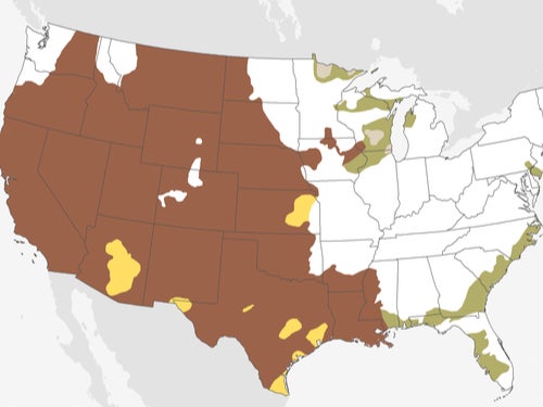
In a worrying new seasonal forecast on Thursday, the US National Weather Service (NWS) predicted continuing or worsening drought across a vast swathe of the country from California to Montana down to Texas.
It comes after the southwestern US experienced its most severe drought on record last year, exacerbated by historic high temperatures that a US government report blamed "significantly" on global warming.
“With nearly 60 per cent of the continental US experiencing minor to exceptional drought conditions, this is the largest drought coverage we’ve seen in the U.S. since 2013," said Jon Gottschalck, head of operational prediction at the NWS's Climate Prediction Center.
"Severe to exceptional drought has persisted in some areas of the West since the summer of 2020 and drought has expanded to the southern Plains and Lower Mississippi Valley."
The agency added that dry conditions would increase the risk of wildfires in the Southwest and the central Great Plains region, following brutal fire seasons in California and Oregon.
Southwest states such as California, Nevada, Arizona and Utah have been in drought for two years now, bringing crucial water reservoirs such as the Hoover Dam to all-time lows.
According to the National Oceanic and Atmospheric Administration (NOAA), between January 2020 and August 2021 the southwest region saw its driest 20-month period since 1895 and its third highest daily average temperature.
While the lack of rainfall was probably due to "natural variations", NOAA said the heat was "significantly" driven by climate change and had "a number of direct impacts on the drought".
Separately, a study published in February found evidence that the southwestern US is now suffering from a "megadrought" – a drought lasting 20 years or more – worse than anything seen in the last 1,200 years.
The study said that about 19 per cent of the megadrought was attributable to climate change. Existing climate models have shown that the current drought would have occurred without climate change but been less severe.
Join our commenting forum
Join thought-provoking conversations, follow other Independent readers and see their replies
Comments