The Arctic is showing stunning winter warmth, and these scientists think they know why

Your support helps us to tell the story
From reproductive rights to climate change to Big Tech, The Independent is on the ground when the story is developing. Whether it's investigating the financials of Elon Musk's pro-Trump PAC or producing our latest documentary, 'The A Word', which shines a light on the American women fighting for reproductive rights, we know how important it is to parse out the facts from the messaging.
At such a critical moment in US history, we need reporters on the ground. Your donation allows us to keep sending journalists to speak to both sides of the story.
The Independent is trusted by Americans across the entire political spectrum. And unlike many other quality news outlets, we choose not to lock Americans out of our reporting and analysis with paywalls. We believe quality journalism should be available to everyone, paid for by those who can afford it.
Your support makes all the difference.Last month, temperatures in the high Arctic spiked dramatically, some 36 degrees Fahrenheit above normal -- a move that corresponded with record low levels of Arctic sea ice during a time of year when this ice is supposed to be expanding during the freezing polar night.
And now this week we're seeing another huge burst of Arctic warmth. A buoy close to the North Pole just reported temperatures close to the freezing point of 32 degrees Fahrenheit (0 Celsius), which is 10s of degrees warmer than normal for this time of year. Although it isn't clear yet, we could now be in for another period when sea ice either pauses its spread across the Arctic ocean, or reverses course entirely.
But these bursts of Arctic warmth don't stand alone -- last month, extremely warm North Pole temperatures corresponded with extremely cold temperatures over Siberia. This week, meanwhile, there are large bursts of un-seasonally cold air over Alaska and Siberia once again.
It is all looking rather consistent with an outlook that has been dubbed "Warm Arctic, Cold Continents" -- a notion that remains scientifically contentious but, if accurate, is deeply consequential for how climate change could unfold in the Northern Hemisphere winter.
The core idea here begins with the fact that the Arctic is warming up faster than the mid-latitudes and the equator, and losing its characteristic floating sea ice cover in the process. This also changes the Arctic atmosphere, the theory goes, and these changes interact with large scale atmospheric patterns that affect our weather (phenomena like the jet stream and the polar vortex). We won't get into the details yet, but in essence, the result can be a kind of swapping of the cold air masses of the Arctic with the warm air masses to the south of them. The Arctic then gets hot (relatively), and the mid-latitudes -- including sometimes, as during the infamous "polar vortex" event of 2013-2014, the United States -- get cold.

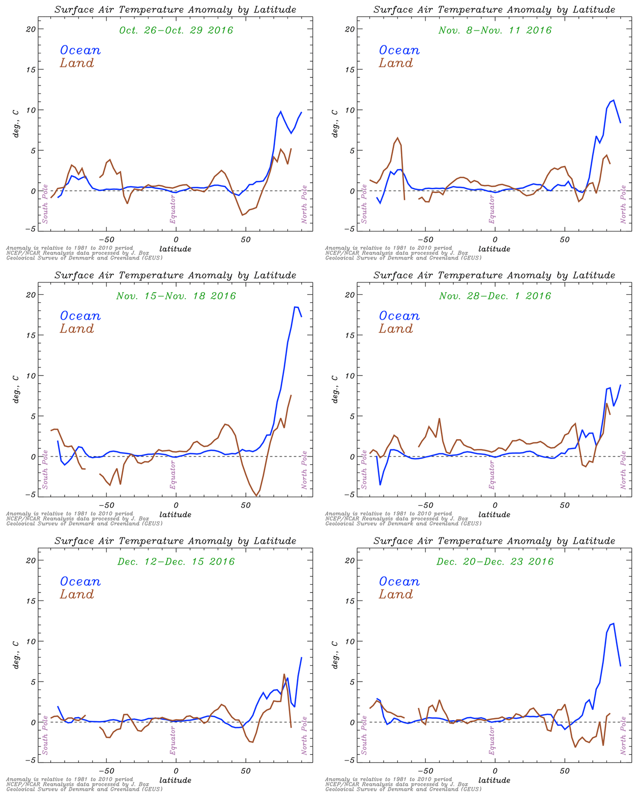
Here's an animation, provided by Jason Box of the Geological Survey of Denmark and Greenland, of what this might look like. It shows that both during the November major Arctic warming event, and again this week, temperatures over the Arctic ocean spiked far above their average, while temperatures over some high or mid-latitude land surfaces in the Northern Hemisphere fell well below average (the Arctic is at the far right):
The image, Box explained by email, "underscores the distinction between ocean and land and thus points to there being something to the pattern" of "Warm Arctic, Cold Continents." He continued:
What are the impacts? Why should we care? For one, the patterns indicate a system changing state. For two: That change probably affects the frequency and persistence of weather, a hallmark of climate change; changing extremes... more hots and ironically sometimes sharper colds.
In recent years, several scientists have come up with different versions or incarnations of the "Warm Arctic, Cold Continents" idea. One of the best known is Rutgers University climate scientist and Arctic specialist Jennifer Francis, who published a 2012 paper with Stephen Vavrus of the University of Wisconsin-Madison arguing that the "Arctic amplification" of global warming was leading to a more wavy and slower-moving jet stream, and this in turn was leading to extreme weather as different atmospheric patterns became stuck in place. Their paper highlighted not only changes in winter, but also throughout the year.
"What I think we've been seeing this year has been totally consistent with the hypothesis that we've been working on," Francis said in an interview of the recent Arctic drama. The jet stream is a global west-to-east flow (Francis often calls it a "river") of air above our heads that carries with it weather we experience. But sometimes, the flow becomes quite elongated, looking much less like a tight loop around the planet and more like a series of slowly undulating waves.
"What I think is happening is that it's been very warm in the Arctic all year long and this has helped favor a very wavy jet stream, which is what we've been seeing," she continued, "and that has helped to pump a lot of extra heat and moisture up into the Arctic."
But then what about the cold continents?
Judah Cohen, the head of seasonal forecasting at Atmospheric and Environmental Research, said that this year in particular, low sea ice in the Arctic has led to a situation in which more snow falls over Siberia in the late fall, as Arctic moisture unlocked from the uncovered ocean gets pulled south over land and falls as snow. This doesn't just make Siberia cold. Cohen believes it creates atmospheric reverberating effects that upset the polar vortex (the cold lower pressure region that normally hovers over the Arctic in winter), causing it to become elongated, migrate southward, and allowing for the swapping of Arctic cold and mid-latitude warmth.
"This year, we had this unprecedented early polar votex weakening, polar vortex split, and that really kicked off this continental cooling we've seen this winter," said Cohen. "It started across Eurasia but obviously in December it's come over North America as well, and so far there's no signs of that going away."
But as Cohen acknowledges, "the community is definitely polarized" over the validity of these ideas. "People are saying that [they] feel very strongly that any kind of cold that we're seeing in the winter is just a product of natural variability, and there's no forcing of it from the Arctic, let's say. But I mean, I think every time you get a cold winter, that argument gets harder and harder to make."
Another early theorist of the "Warm Arctic, Cold Continents" concept is James Overland, a researcher with the Pacific Marine Environmental Laboratory of the National Oceanic and Atmospheric Administration, who co-authored a paper on the topic in 2011, just after a record-breaking snowy Washington, D.C. winter in 2010. It concluded:
Increased atmospheric temperatures over loss of sea ice areas, creates a meander in the polar vortex flow which will have different downstream effects in different years. Given a continuing trend for increased temperatures and thinner sea ice in the Arctic, modelling results and the data from recent late autumns, December 2008, 2009 and 2010, suggest that the frequency of an autumn warm Arctic--cold continents climate pattern will increase....
"There are a lot of people in both camps," Overland now says of the debate over these ideas. "It's fairly evenly matched."
But as he continues, referring to the present moment, "I think there's a strong case to be made that we're seeing the first real strong example of the loss of sea ice north of Alaska helping to lock in the longwave pattern and the cold temperatures on the East Coast." (Francis, Cohen, and Overland were all co-authors of a 2014 review paper that looked at the evidence for whether the warming Arctic was indeed causing extreme weather effects in the mid-latitudes.)
If these ideas are correct, they're hugely important -- and not only because of the consequences for the weather we all experience in the mid-latitudes of the Northern Hemisphere. It's also important because paradoxically, it could give momentum to climate change doubters, who will constantly be pointing to major snowstorms and cold temperatures where they live in order to cast doubt on the overall climate trend, even though it would be precisely that trend that is driving those select bouts of cold (even as the globe overall still shows a warming trend).
Recently I checked in with one of the major skeptics of all of this -- National Center for Atmospheric Research climate scientist Kevin Trenberth, who has debated Francis in the past, arguing that much of what she's citing could be chalked up to natural climate variability and noting that climate change models don't produce these effects.
Trenberth didn't deny that the fast-warming Arctic could have some ramifications outside of the Arctic. But he pointed out that the tropics of the Earth have a greater pull on weather overall and argued that processes happening in the Arctic winter aren't that powerful, in the perspective of the globe as a whole. As he put it:
What happens in the Arctic may not stay in the Arctic, but events there are always combined with other places: so in November the cold air formed but went over to Siberia. More recently we had the cold outbreak in the US. It is not as if there is not cold air! These events are complicit and there is some randomness to them: we call it "weather."
In fact, in a sign of possible moderating of the debate, Francis said she agrees that "the tropics rule the world," and the Arctic is acting as more of a modulator. "We're saying that they do rule the world in a way but the Arctic can really change how their natural influence would typically happen. We're seeing them intensify a pattern or maybe even reduce it." For instance, if tropical weather causes a major excursion of the jet stream northward, Arctic warming can then exacerbate that, she said.
So for now, these ideas aren't accepted by all of the relevant scientists -- but they definitely have a core group of supporters who are publishing, arguing, and citing recent events to advance their case. Scientists are gathering in Washington, D.C. in February to hash them out further -- by which time, we'll know more about just how much winter weather itself has given momentum to the conversation.
"We continue to see this Arctic behaving so bizarrely, I think we're in for a very interesting winter," said Francis.
Washington Post
Join our commenting forum
Join thought-provoking conversations, follow other Independent readers and see their replies
Comments