Overheating planet has turned America’s winter into a freakshow
Winter is warming faster than any other season in the United States
Your support helps us to tell the story
From reproductive rights to climate change to Big Tech, The Independent is on the ground when the story is developing. Whether it's investigating the financials of Elon Musk's pro-Trump PAC or producing our latest documentary, 'The A Word', which shines a light on the American women fighting for reproductive rights, we know how important it is to parse out the facts from the messaging.
At such a critical moment in US history, we need reporters on the ground. Your donation allows us to keep sending journalists to speak to both sides of the story.
The Independent is trusted by Americans across the entire political spectrum. And unlike many other quality news outlets, we choose not to lock Americans out of our reporting and analysis with paywalls. We believe quality journalism should be available to everyone, paid for by those who can afford it.
Your support makes all the difference.January has unleashed a string of extreme weather events across the United States.
On Wednesday, up to four inches of rain fell in southeast Texas with reports of heavy flooding across the Austin and San Antonio areas.
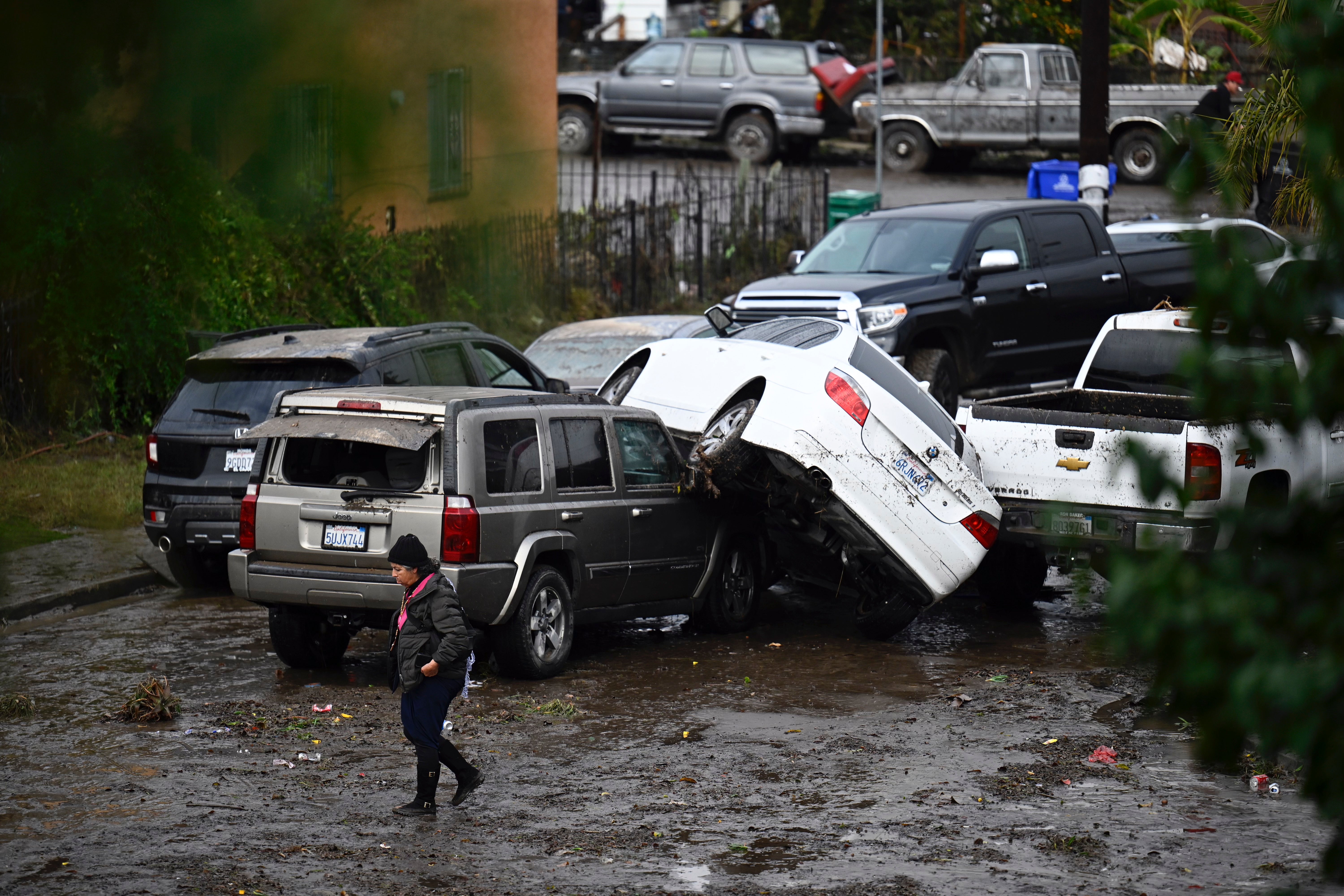
Earlier this week, a state of emergency was declared in San Diego, California, after a violent storm dropped three inches of rain in three hours – the city’s fourth-wettest day since record-keeping began.
Across the Midwest and Northeast, a generally mild December was followed by a brutal January with record-cold temperatures, and the heaviest snow cover in 20 years after back-to-back storms. By the middle of the month, half of the Lower 48 was covered in snow after Arctic blasts swept the Plains to the Great Lakes, and from the south up through the northeast.
New York City saw its single biggest snowfall after a record drought (but it still amounted to less than two inches). On 15 January, the night of the Iowa caucuses, wind chill made temperatures feel like 35 degrees below zero in parts of the state.
Extreme cold may seem counterintuitive on an overheating planet but overall, winter is the fastest warming season due to the climate crisis, scientists have found.
Atmospheric Rivers
San Diego, which typically gets an average two inches of rain in January, was devastated by Monday’s deluge. Entire neighbourhoods were left several feet underwater as rushing torrents swept vehicles into crumpled heaps.
Few residents have flood insurance in the city and even before private damages are assessed, officials said there was up to $7m in public infrastructure damage. UCLA climate scientist, Dr Daniel Swain, wrote on X, formerly Twitter, that it was the second historic rainfall event in central and southern California this winter after a separate event impacted Ventura in December. He added that “much warmer than average ocean temps over the Pacific (both near shore and offshore) are probably playing at least a partial role”.
Another storm is on the way: the National Weather Service warned that an “impactful” atmospheric river event will likely move south along the West Coast from 31 January to 5 February with the risk of localised flooding and landslides.
An “atmospheric river”, also dubbed a “river in the sky”, is a band of water vapor that forms over the ocean and can be hundreds of miles wide.
These weather phenomena occur globally, but are common on the US West Coast where they drag moisture onshore from the Pacific to create up to half of annual rainfall – and causing some of the region’s most catastrophic flooding.
Atmospheric rivers can carry water vapor equivalent to the average flow at the mouth of the Mississippi River, according to the National Oceanic and Atmospheric Administration (NOAA).
The events are becoming more intense due to the climate crisis, scientists have warned. A hotter atmosphere and a warmer ocean increase the amount of moisture carried by atmospheric rivers, leading to heavier downpours and more risk of flash flooding.
Extreme cold, snow and ice
Winter freezes and snow storms don’t cancel out decades of global heating, the nonprofit group, Climate Nexus, noted.
While higher temperatures are more pronounced in summer, winter is warming faster in the US. In some northern states, this is happening at twice the rate of summer months, and overall, snow and ice cover are declining year-on-year due to climate impacts.
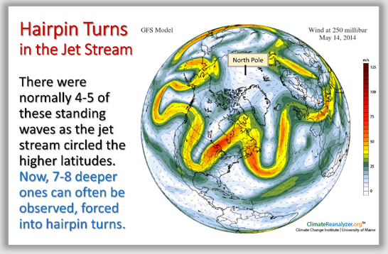
But extreme, record-breaking weather events will still occur, possibly due to rapid changes in the Arctic, which is warming four times faster than the rest of the world.
Some recent studies have suggested that Arctic warming has a major impact on the jet stream, causing it to weaken and develop large dips. When the jetstream makes one of these dips, it sends cold air further south and leads to severe winter weather events.
However, according to the latest National Climate Assessment (NCA) from the US government, these Arctic blasts, while still cold in absolute terms, are warmer than four decades ago.
Flash flooding
One of the clearest changes in the weather across the US due to climate change is the increasing frequency and intensity of heavy rainfall, Climate Nexus said.
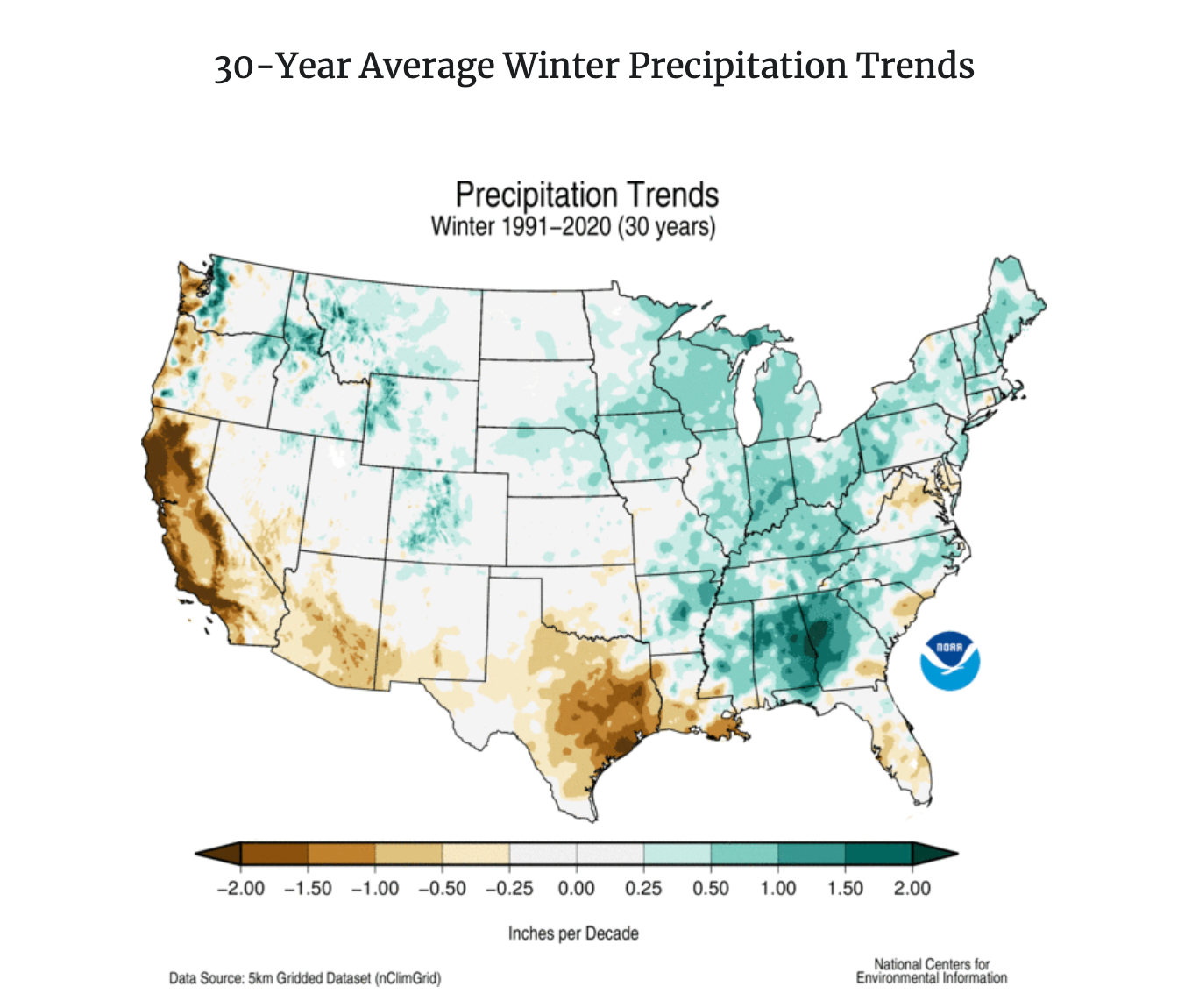
As the atmosphere warms, more precipitation falls as rain rather than snow. In the central and eastern US, the average annual precipitation in the last 20 years was up to 15 per cent higher than the start of the 20th century.
In the Southwest, while rainfall was now well below average in summer, fall, and spring, it is 10-15 per cent above average in the winter. The Pacific Northwest also experiences drier summers and wetter winters, according to the NCA.
With more rain and less snow not only does the threat of flooding increase but the snowpack dwindles. This has a knock-on effect for a region throughout the year, on freshwater supplies and drought conditions.
Join our commenting forum
Join thought-provoking conversations, follow other Independent readers and see their replies
Comments