Late-winter ‘bomb cyclone’ tracking up East Coast threatening 70 million with ferocious winds, snow
More than 12 inches of snow expected in parts of the interior northeast and may cause some power outages
Your support helps us to tell the story
From reproductive rights to climate change to Big Tech, The Independent is on the ground when the story is developing. Whether it's investigating the financials of Elon Musk's pro-Trump PAC or producing our latest documentary, 'The A Word', which shines a light on the American women fighting for reproductive rights, we know how important it is to parse out the facts from the messaging.
At such a critical moment in US history, we need reporters on the ground. Your donation allows us to keep sending journalists to speak to both sides of the story.
The Independent is trusted by Americans across the entire political spectrum. And unlike many other quality news outlets, we choose not to lock Americans out of our reporting and analysis with paywalls. We believe quality journalism should be available to everyone, paid for by those who can afford it.
Your support makes all the difference.Some 70 million people are in the path of a widespread, late-winter storm packed with snow and strong winds tracking up the East Coast of America this weekend.
Winter weather alerts were issued across states, with the system expected to strengthen into a “bomb cyclone” over the northeast.
On Friday morning, the Midwest, Kansas and Missouri were being slammed with heavy snow, making driving conditions treacherous. Temperatures from the Midwest down to Texas were expected to plummet 20-30 degrees below normal. By Friday night, snow is expected to fall in interior parts of the eastern states.
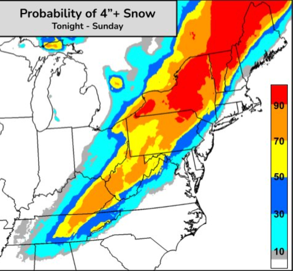
On Saturday, the ramped-up bomb cyclone is set to bring ferocious winds and heavy snow to parts of New York and Pennsylvania.
More than an inch of snow per hour is expected to fall and, when combined with gusty winds, will reduce visibility and make driving dangerous, according to the National Weather Service’s Weather Prediction Center.
The worst of the storm will impact the interior northeast with more than 12 inches of snow likely in parts. Some power outages may occur, the NWS said.
The FlightAware “Misery Map” reported 640 delays and 39 cancellations on Friday morning with the major airport hubs of Chicago O’Hare, Atlanta Hartsfield-Jackson and Charlotte Douglas the worst affected.
A bomb cyclone is essentially a winter hurricane, and common on the Eastern Seaboard. The typically large storm becomes a “bomb cyclone” when it undergoes a process called bombogenesis, according to Scientific American, and sees a rapid drop in atmospheric pressure over 24 hours.
While it may seem illogical, winter storms which drop more snow are an expected outcome of the climate crisis. As the planet heats, more water evaporates and builds up moisture in the atmosphere. In summer this means more torrential downpours while in winter that takes the form of heavy snow.

Late on Friday, heavy rain and severe thunderstorms are expected in the Florida Panhandle, which will come as a relief in areas that have been gripped by wildfires. Forecasters warned that the heavy rain could lead to flash flooding from the central Florida Panhandle into southern Georgia.
Overnight into Saturday, there was a risk of severe thunderstorms for much of the central Gulf Coast and up the Atlantic Seaboard, with the threat of damaging winds, isolated hail and a few tornadoes possible.
The winter storm system will bring much colder air across the southeast and Mid-Atlantic, with lows likely below freezing along the Gulf Coast and northern Florida by Sunday morning, the NWS reported.
Across the Great Plains and Mississippi Valley, an Arctic blast will drive frigid temperatures, expanding east into the Midwest and Deep South on Saturday, before shifting up the East Coast. In North Dakota, temperatures will hover around the single digits on Friday.
A new weather system rolling in over the Pacific Northwest on Saturday means potential heavy rain along coastlines, and heavy snowfall to the Cascades and Northern Rockies.


Join our commenting forum
Join thought-provoking conversations, follow other Independent readers and see their replies
Comments