Hurricane Lee powers through Caribbean as forecasters warn ‘too soon to know’ of US impact next week
‘We will see waves between 10 and 15 feet (3- 5metres), so we don’t want anyone on the beaches’
Your support helps us to tell the story
From reproductive rights to climate change to Big Tech, The Independent is on the ground when the story is developing. Whether it's investigating the financials of Elon Musk's pro-Trump PAC or producing our latest documentary, 'The A Word', which shines a light on the American women fighting for reproductive rights, we know how important it is to parse out the facts from the messaging.
At such a critical moment in US history, we need reporters on the ground. Your donation allows us to keep sending journalists to speak to both sides of the story.
The Independent is trusted by Americans across the entire political spectrum. And unlike many other quality news outlets, we choose not to lock Americans out of our reporting and analysis with paywalls. We believe quality journalism should be available to everyone, paid for by those who can afford it.
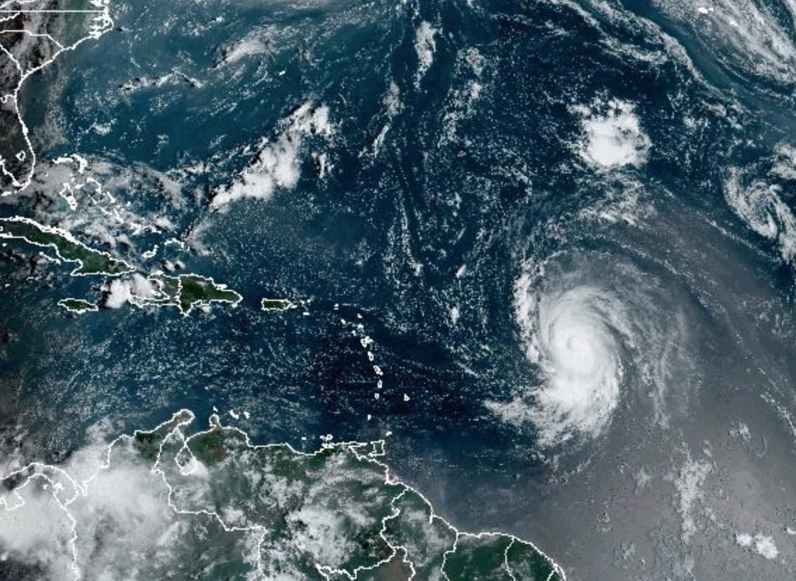
Your support makes all the difference.Hurricane Lee was declared a “powerful” cyclone on Friday and is expected to remain so as forecasters warned it was “too soon to know” about potential US impacts next week.
The storm hit Category 5 – the first cyclone to do so this season – with winds of 150mph (250km/h) on Friday. While it has since been downgraded to Cat-4, forecasters expected its intensity to fluctuate in the coming days.
Lee is not expected to make landfall and pass well north of the northern Leeward Islands, Virgin Islands, and Puerto Rico, creating “dangerous beach conditions”, according to the National Hurricane Center (NHC).
Dangerous surf and deadly rip currents would impact the northern Leeward Islands on Friday then reach Puerto Rico, Hispaniola, Turks and Caicos, Bahamas, and Bermuda this weekend.
“We will see waves between 10 and 15 feet (3- 5metres), so we don’t want anyone on the beaches,” said Ernesto Morales with the National Weather Service (NWS) in San Juan, Puerto Rico.


Similar, life-threatening conditions are expected to begin along most of the US East Coast on Sunday, NHC reported.
However “it is way too soon” to know what level of impacts, if any, the system might have along the US East Coast, Atlantic Canada or Bermuda by late next week, according to NWS.
Varying weather models told different stories. The European Centre for Medium-Range Weather Forecasts showed Hurricane Lee not making landfall but skirting the continental US with high winds and heavy rain near the far eastern end of Long Island.
The Global Forecast System (GFS) in the US showed Lee coming close to Cape Cod and then impacting Atlantic Canada.
What forecasters are watching closely is an upper-level trough in the jet stream which will have consequences for how Lee pans out. If the trough is further east, then Lee spins out into the Atlantic Ocean. Further west means Lee could be a rare occurrence and pulled towards the East Coast, similar to the infamous “hook” of the devastating Superstorm Sandy in 2012.
While there’s optimism that Hurricane Lee will not make landfall, the system’s rapid intensification – leaping from a Category 1 to Category 5 in the span of 24 hours – was deep cause for concern in the scientific community.
“Lee’s rapid intensification to a Category 5 is a harbinger of the future. We should expect more cases of rapid intensification as the climate continues to warm,” said Jeff Masters, a meteorologist for Yale Climate Connections and former hurricane scientist with the National Oceanic and Atmospheric Administration, told NBC.
As the global temperature increases, due to carbon emissions from burning fossil fuels, the ocean is taking a major hit. The ocean has absorbed 90 per cent of warming in the past few decades and all that extra heat is driving historically-high water temperatures, supercharging tropical cyclones.
Lee is the 12th named storm of the Atlantic hurricane season, which runs from 1 June to 30 November. The season usually peaks in September.
Join our commenting forum
Join thought-provoking conversations, follow other Independent readers and see their replies
Comments