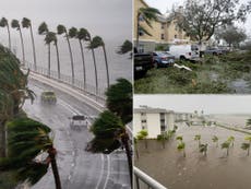
Hurricane warning issued for South Carolina as Ian moves north
The storm will strenthen into a hurricane Thursday night and make landfall again on Friday
Your support helps us to tell the story
From reproductive rights to climate change to Big Tech, The Independent is on the ground when the story is developing. Whether it's investigating the financials of Elon Musk's pro-Trump PAC or producing our latest documentary, 'The A Word', which shines a light on the American women fighting for reproductive rights, we know how important it is to parse out the facts from the messaging.
At such a critical moment in US history, we need reporters on the ground. Your donation allows us to keep sending journalists to speak to both sides of the story.
The Independent is trusted by Americans across the entire political spectrum. And unlike many other quality news outlets, we choose not to lock Americans out of our reporting and analysis with paywalls. We believe quality journalism should be available to everyone, paid for by those who can afford it.
Your support makes all the difference.A hurricane warning has been issued for the South Carolina coast, in anticipation of new impacts from Tropical Storm Ian.
The storm is expected to restrengthen into a hurricane as it passes into the Atlantic off the coast of Florida, and will bring hurricane-force winds, severe rain and storm surge to the South Carolina coast, according to the National Hurricane Centre (NHC).
Residents have been encouraged to complete preparations as soon as possible. The storm is forecast to make landfall in the state on Friday as a category 1 hurricane.
Parts of South Carolina could see up to seven feet (two metres) of storm surge, along with up to 12in (30cm) of rain and heavy winds, NHC warns. Wind speeds in some areas could reach up to 110mph (177kmph).
The North Carolina and Georgia coasts are under tropical storm warnings, as the outer edges of the storm will likely bring severe weather to the area.
The storm system is then forecast to move inland over the weekend as a tropical depression, bringing heavy rains to Appalachian North Carolina, Virginia, West Virginia and Kentucky.
On Wednesday, South Carolina governor Henry McMaster declared a state of emergency in anticipation of the storm’s impact. Residents should monitor warnings and guidance from local officials on the potential impact and necessary preparations over the next day.
School districts across South Carolina have shifted to online learning or early dismissal on Thursday as the area prepares for the storm, according to the state government. In addition, government offices in coastal Charleston and Beaufort counties have closed.
The South Carolina Gamecocks college football game was rescheduled to Thursday night, in anticipation of the storm’s impact on Friday. Other sites, like the South Carolina Aquarium in Charleston, will be closed on Thursday and Friday.
Hurricane Ian brought widespread devastation to Florida after hitting the Gulf Coast as a strong category 4 storm. At least six deaths in the state have so far been reported, including five in Lee County, home to the cities of Fort Myers and Cape Coral.
More than 2 million people are still without power across Florida, according to poweroutage.us.
Strong hurricanes like Ian are likely to become more common as the climate crisis grows. Warmer air and ocean waters can power up a storm as it reaches land, fuelling dangerous winds and rainfall.


Join our commenting forum
Join thought-provoking conversations, follow other Independent readers and see their replies
Comments