Your support helps us to tell the story
From reproductive rights to climate change to Big Tech, The Independent is on the ground when the story is developing. Whether it's investigating the financials of Elon Musk's pro-Trump PAC or producing our latest documentary, 'The A Word', which shines a light on the American women fighting for reproductive rights, we know how important it is to parse out the facts from the messaging.
At such a critical moment in US history, we need reporters on the ground. Your donation allows us to keep sending journalists to speak to both sides of the story.
The Independent is trusted by Americans across the entire political spectrum. And unlike many other quality news outlets, we choose not to lock Americans out of our reporting and analysis with paywalls. We believe quality journalism should be available to everyone, paid for by those who can afford it.
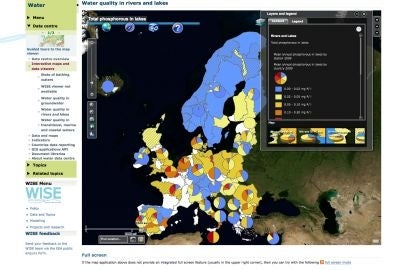
Your support makes all the difference.The European Environmental Agency (EEA) announced on July 25 an update to its series of interactive virtual maps on water quality around Europe.
The EAA was created by the European Union to help the EU and its member states make decisions regarding the environment and sustainability.
The agency publishes a series of interactive maps on European water quality based on the latest available data from each country; these maps are free to access and, according to the EEA, are designed to be used by either "water professionals" or "anyone with an interest in environmental issues affecting their local river, lake or sea."
On July 25, the EEA announced updates to four of these data sets - Transitional, costal and marine waters (TCM), Rivers and lakes, Groundwater and Urban waste water. The updates, according to the EEA, are designed to make the maps more compact and give them a more user-friendly appearance. Specific changes include the ability to quickly switch between maps of different pollutants and the inclusion of national level overviews dating back several years.
Each of the four updated maps can be accessed via either the EEA home page ( http://www.eea.europa.eu) or the links below:
TCM - http://www.eea.europa.eu/highlights/themes/water/interactive/soe-tcm
Rivers and lakes - http://www.eea.europa.eu/highlights/themes/water/interactive/soe-rl
Groundwater - http://www.eea.europa.eu/highlights/themes/water/interactive/soe-gw
Urban waste water - http://www.eea.europa.eu/highlights/themes/water/interactive/soe-wfd/uwwtd
Further information about the quality of Europe's environment can be accessed by members of the public via the following links:
Ozone pollution - http://www.eea.europa.eu/maps/ozone/map
Air pollution - http://www.airqualitynow.eu/
UV Index - http://www.metoffice.gov.uk/weather/europe/europe_uv.html
Join our commenting forum
Join thought-provoking conversations, follow other Independent readers and see their replies
Comments