Southern California brace for mudslides as ‘biggest storm of the year’ barrels in
Heavy rain brings threat of flash flooding to southern California while five feet of snow expected in Sierras
Your support helps us to tell the story
From reproductive rights to climate change to Big Tech, The Independent is on the ground when the story is developing. Whether it's investigating the financials of Elon Musk's pro-Trump PAC or producing our latest documentary, 'The A Word', which shines a light on the American women fighting for reproductive rights, we know how important it is to parse out the facts from the messaging.
At such a critical moment in US history, we need reporters on the ground. Your donation allows us to keep sending journalists to speak to both sides of the story.
The Independent is trusted by Americans across the entire political spectrum. And unlike many other quality news outlets, we choose not to lock Americans out of our reporting and analysis with paywalls. We believe quality journalism should be available to everyone, paid for by those who can afford it.
Your support makes all the difference.California is facing potentially its biggest storm of the year as a powerful weather system barrelled down the state on Tuesday.
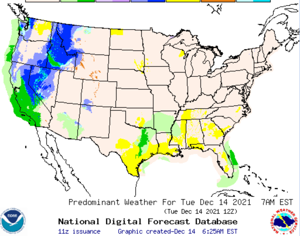
The potent system will bring hazardous conditions to the Golden State before shifting east on Wednesday. The National Weather Service warned that southern California faced risk of excessive rainfall, of up to three inches, along with a high wind event.
Heavy rain brings the risk of localised areas of flash flooding with urban areas, roads, and small streams the most vulnerable, forecasters warned. It also increased concerns of debris flows or mudslides in areas where land has been destabilised by wildfires.
The heaviest downpours were expected early on Tuesday in the Los Angeles area before moving into Orange County and the Inland Empire. The severe weather led to several collisions on the roads and sections of major routes being closed down.
Despite the treacherous conditions, the storm brought much-needed rain to California when much of the state remains in extreme and exceptional drought conditions.
Heavy snowfall of more than five feet was expected in parts of the Sierra Nevada mountain range, making travel difficult.
“Sure, you’ve heard of ‘Elf on the Shelf’, but how about ‘Fountain on the Mountain’?” NWS forecasters tweeted.
Flurries were also expected in the Cascades, northern Rockies and into the Great Basin through Thursday. The snow will result in reduced visibility and hazardous driving conditions, NWS said.
In the southern and central region of the High Plains, and across much of the Texas panhandle, high temperatures, low humidity and gusty winds of 15-20mph raise the risk of wildfires into Wednesday.
Temperatures will be 20 to 30 degrees above average over parts of the Plains into the Mississippi Valley, with showers and thunderstorms forecast.
Overnight on Wednesday, the weather will increase in intensity with risk of severe thunderstorms over parts of the Upper and Middle Mississippi Valley into Thursday.

The hazards associated with these thunderstorms are frequent lightning, severe thunderstorm wind gusts, hail, and a few tornadoes, NWS reported.
The warmer temperatures will bring see more moisture stream northward as far as the Great Lakes overnight on Tuesday.
The Northeast will see rain by Wednesday night with snowfall at higher elevations in the northern parts of New England.

Join our commenting forum
Join thought-provoking conversations, follow other Independent readers and see their replies
Comments