Stunning satellite images show how bomb cyclone drenched drought-ravaged California
San Francisco had its wettest day in 30 years on New Year’s Eve
Your support helps us to tell the story
From reproductive rights to climate change to Big Tech, The Independent is on the ground when the story is developing. Whether it's investigating the financials of Elon Musk's pro-Trump PAC or producing our latest documentary, 'The A Word', which shines a light on the American women fighting for reproductive rights, we know how important it is to parse out the facts from the messaging.
At such a critical moment in US history, we need reporters on the ground. Your donation allows us to keep sending journalists to speak to both sides of the story.
The Independent is trusted by Americans across the entire political spectrum. And unlike many other quality news outlets, we choose not to lock Americans out of our reporting and analysis with paywalls. We believe quality journalism should be available to everyone, paid for by those who can afford it.
Your support makes all the difference.Before-and-after Nasa satellite images have revealed how several weeks of severe storms have flooded swathes of drought-stricken California.
Heavy rainfall drenched central and northern California on New Year’s Eve. The National Weather Service (NWS) recorded 5.5 inches of rain in downtown San Francisco, the wettest day in 30 years, while five inches fell on the state capital Sacramento.
At least one person died and thousands were evacuated from their homes. Mountain roads in the Sierra Nevada range were blocked by heavy snowfall and dozens of people had to be rescued after floodwaters submerged vehicles. A 200-foot section of a levee system protecting rural vineyards and cattle ranches was washed away by roaring waters.
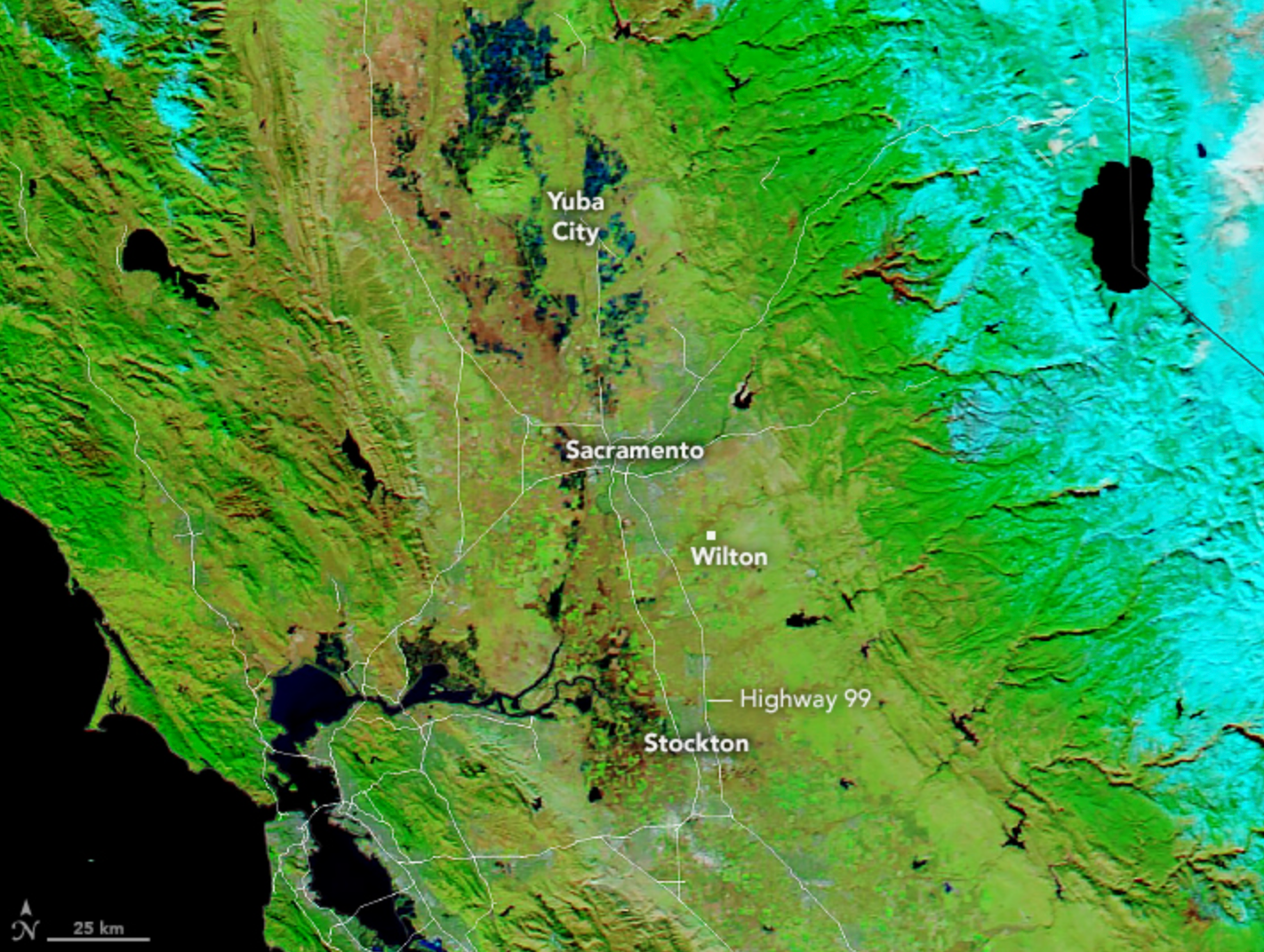
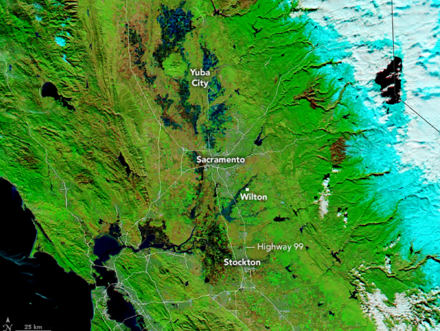
Images captured from space on 1 January 2023 using the Moderate Resolution Imaging Spectroradiometer (MODIS) on NASA’s Aqua satellite revealed how the region quickly became saturated by flooding. An earlier image, captured on 16 December 2022 showed bare and dry land by comparison.
The images showed stark differences in waterways along the busy Golden State Highway close to Yuba City, Sacramento, Wilton and Stockton.


Warnings of excessive rainfall have been issued for millions of people in California again this week. NWS warned of a so-called “Pineapple Express” barrelling in from Hawaii with strong winds in combination with a bomb cyclone that will fuel walls of intense rain and snow squalls.
On Wednesday, the National Weather Service in San Francisco warned of a “potent” atmospheric river impacting the region through today and overnight into Thursday.
An “atmospheric river” - or “river in the sky” - is a band of water vapor that forms over the ocean and can be nearly 400 miles in width.
These weather phenomenon occur globally, but are common on the US West Coast where they drag moisture onshore from the Pacific and account for up to half of annual rainfall. Such extreme weather events are being intensified by the climate crisis.
The event will bring substantial rainfall to the San Francisco Bay Area and Central Coast, dropping more water onto already saturated soils and increasing the risk of flash flooding and landslides in steep areas.
In addition strong gusty winds will bring branches and trees down, which may cause localized damming of water ways, NWS warned.
Join our commenting forum
Join thought-provoking conversations, follow other Independent readers and see their replies
Comments